Trat Province
Trat
ตราด | |
|---|---|
 | |
 Flag  Seal | |
 Map of Thailand highlighting Trat Province | |
| Coordinates: 12°24′N 102°31′E / 12.400°N 102.517°ECoordinates: 12°24′N 102°31′E / 12.400°N 102.517°Ecenter of province | |
| Country | Thailand |
| Capital | Trat |
| Government | |
| • Governor | Pinyo Prakobphon (since October 2020)[1] |
| Area | |
| • Total | 2,819 km2 (1,088 sq mi) |
| Area rank | Ranked 62nd |
| Population (2019)[3] | |
| • Total | 229,958 |
| • Rank | Ranked 74th |
| • Density | 81.57/km2 (211.3/sq mi) |
| • Density rank | Ranked 60th |
| Human Achievement Index | |
| • HAI (2017) | 0.6049 "somewhat high" Ranked 27th |
| Time zone | UTC+7 (ICT) |
| Postal code | 23xxx |
| Calling code | 039 |
| ISO 3166 code | TH-23 |

Trat (Thai: ตราด, pronounced [tràːt]) is one of seventy-seven provinces (changwat) located in eastern Thailand the easternmost region along the Thai coast. It has borders with Chanthaburi Province to the northwest, Cambodia to the east, and the Gulf of Thailand to the south. Trat is 315 km from Bangkok.[5]
Trat is known for gemstone mining and trading.
Etymology[]
Trat is believed to be a corruption of “Krat”(กราด) the Thai name for the tree Dipterocarpus intricatus, common to the region and used to make brooms.[6]
History[]
The history of Trat can be traced back to the early 17th century during the reign of King Prasat Thong of the Ayutthaya Kingdom. Formerly known as Mueang Thung Yai, Trat has played an important role in the development of the country's stability and economy due to its strategic location. The town of Trat later become a community of Chinese merchants.
After the fall of Ayutthaya to the Burmese in 1767, Trat served as a checkpoint and buffer city and was responsible for providing provisions to King Taksin the Great before he moved his forces from Chanthaburi to Ayutthaya. King Taksin then succeeded in driving out the Burmese invaders and liberated the kingdom from foreign rule.
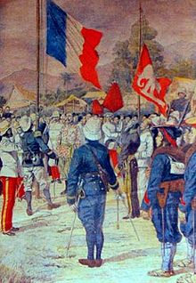
In the Rattanakosin era, during the 1893 Paknam crisis, French troops landed and occupied the western part of Chantaburi Province. In 1904, Siam was forced to surrender Trat to French Indochina in order to regain Chantaburi. Three years later, however, finding that Trat with its almost entirely Thai population was hard to rule, the French returned Trat to Thailand on 23 March 1907, in exchange for larger areas along the Mekong river, which included Battambang, Siam Nakhon, and Sisophon, which all have a Khmer majority population.
During the French-Thai War of 1940–1941, the Vichy French navy sailed from Saigon to seize Trat. The unprepared Thai warships were caught by surprise. By the end of the 17 January 1941 Battle of Ko Chang, three Thai ships had been left sinking: the HTMS Chonburi, HTMS Songkhla, and HTMS Thonburi. French casualties were light with no ships lost. The Japanese government negotiated a truce, which ended the conflict without further fighting.
When the Vietnamese pushed the Khmer Rouge out of Cambodia in 1985, Pol Pot fled to Thailand and made his headquarters in a plantation villa near Trat. It was built for him by the Thai Army and nicknamed "Office 87".[7]
Geography[]
The province covers a land area of 2,917 km2 (1,126 sq mi).[8] The total forest area is 899 km2 (347 sq mi) or 31.4 percent of provincial area.[9]
The Cardamom mountain range forms the boundary to Cambodia in the east of the province, where Trat has borders with three Cambodian provinces: Battambang, Pursat, and Koh Kong.
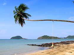
The third biggest island of Thailand is the province's Ko Chang (after Phuket and Ko Samui). The island and more than 40 surrounding smaller islands form the Mu Ko Chang Marine National Park.
Other islands of the province include Ko Kham, Ko Mak, and Ko Phi.
Climate[]
Most of Thailand receives from 1,200 to 1,600 mm of precipitation per year. Two provinces, Trat and Ranong, receive more than 4,500 mm a year making them the wettest places in the country.[10]
Symbols[]
The provincial seal shows the sea with the Khao Banthat mountain range in the background.
The provincial tree is the tropical almond (Terminalia catappa).
Administration[]

Provincial government[]
The province is divided into seven districts (amphoes). These are further divided into 38 subdistricts (tambons) and 254 villages (mubans).
- Mueang Trat /məʊŋtrɑt/
- Khlong Yai /klɔŋyɑɪ/
- Khao Saming /kăo-sà-mĭŋ/
- Bo Rai bɔː rɑɪ/
- Laem Ngop /læmŋɔːb/
- Ko Kut gɔguːd/
- Ko Chang /gɔtʃɑːŋ/
Local government[]
As of 26 November 2019 there are:[11] one Trat Provincial Administration Organisation (ongkan borihan suan changwat) and 14 municipal (thesaban) areas in the province. Trat has town (thesaban mueang) status. Further 13 subdistrict municipalities (thesaban tambon). The non-municipal areas are administered by 29 Subdistrict Administrative Organisations - SAO (ongkan borihan suan tambon).[3]
Transport[]
Air[]
Trat is served by Trat Airport, built and operated by Bangkok Airways.
Human achievement index 2017[]
| Health | Education | Employment | Income |
| 6 | 26 | 16 | 38 |
| Housing | Family | Transport | Participation |

|
 |

|
|
| 77 | 64 | 12 | 18 |
| Province Trat, with an HAI 2017 value of 0.6049 is "somewhat high", occupies place 27 in the ranking. | |||
Since 2003, United Nations Development Programme (UNDP) in Thailand has tracked progress on human development at sub-national level using the (HAI), a composite index covering all the eight key areas of human development. National Economic and Social Development Board (NESDB) has taken over this task since 2017.[4]
| Rank | Classification |
| 1 - 15 | "high" |
| 16 - 30 | "somewhat high" |
| 31 - 45 | "average" |
| 45 - 60 | "somewhat low" |
| 61 - 77 | "low" |
| showMap with provinces and HAI 2017 rankings |

Gallery[]

A wooden bridge to the pier at Ko Lao Ya Nai, Mu Ko Chang National Park

The third biggest island of Thailand - Ko Chang. The name Ko Chang means 'Elephant Island' and derives from its elephant-shaped headland.


References[]
- ^ "ประกาศสำนักนายกรัฐมนตรี เรื่อง แต่งตั้งข้าราชการพลเรือนสามัญ" [Announcement of the Prime Minister's Office regarding the appointment of civil servants] (PDF). Royal Thai Government Gazette. 137 (Special 194 Ngor). 12. 24 August 2020. Retrieved 13 April 2021.
- ^ Advancing Human Development through the ASEAN Community, Thailand Human Development Report 2014, table 0:Basic Data (PDF) (Report). United Nations Development Programme (UNDP) Thailand. pp. 134–135. ISBN 978-974-680-368-7. Retrieved 17 January 2016, Data has been supplied by Land Development Department, Ministry of Agriculture and Cooperatives, at Wayback Machine.CS1 maint: postscript (link)[dead link][failed verification]
- ^ Jump up to: a b "ร่ยงานสถิติจำนวนประชากรและบ้านประจำปี พ.ศ.2561" [Statistics, population and house statistics for the year 2018]. Registration Office Department of the Interior, Ministry of the Interior. stat.bora.dopa.go.th (in Thai). 31 December 2018. Archived from the original on 2 April 2019. Retrieved 20 June 2019.
- ^ Jump up to: a b Human achievement index 2017 by National Economic and Social Development Board (NESDB), pages 1-40, maps 1-9, retrieved 14 September 2019, ISBN 978-974-9769-33-1
- ^ "About Trat". Tourism Authority of Thailand (TAT). Archived from the original on 14 January 2016. Retrieved 21 March 2015.
- ^ "Trat, General Infomation". www.thai-tour.com. Retrieved 25 March 2021.
- ^ Shenon, Philip (6 February 1994). "Pol Pot, the Mass Murderer Who Is Still Alive and Well". The New York Times. Retrieved 11 July 2017.
- ^ "General Information". Trat Province. Retrieved 21 June 2019.
- ^ "ตารางที่ 2 พี้นที่ป่าไม้ แยกรายจังหวัด พ.ศ.2562" [Table 2 Forest area Separate province year 2019]. Royal Forest Department (in Thai). 2019. Retrieved 6 April 2021, information, Forest statistics Year 2019CS1 maint: postscript (link)
- ^ "The Climate of Thailand" (PDF). Thai Meteorological Department (TMD). p. 4. Retrieved 21 June 2019.
- ^ "Number of local government organizations by province". dla.go.th. Department of Local Administration (DLA). 26 November 2019. Retrieved 10 December 2019.
15 Trat: 1 PAO, 1 Town mun., 13 Subdistrict mun., 29 SAO.
Further reading[]
- "เตร็ดเตร่ตราด [Wandering about Trat]". Osotho Magazine (in Thai). Tourism Authority of Thailand (TAT). 59 (10). May 2019. ISSN 0125-7226.
External links[]
| Wikimedia Commons has media related to Trat Province. |
 Trat travel guide from Wikivoyage
- Trat provincial map, coat of arms and postal stamp
| show Places adjacent to Trat Province |
|---|
| show Authority control |
|---|
- Trat Province
- Provinces of Thailand
- Gulf of Thailand