Mahdia
Mahdia
المهدية | |
|---|---|
 | |
|
Seal | |
 Mahdia Location in Tunisia | |
| Coordinates: 35°30′N 11°04′E / 35.500°N 11.067°ECoordinates: 35°30′N 11°04′E / 35.500°N 11.067°E | |
| Country | |
| Governorate | Mahdia Governorate |
| Population (2014) | |
| • Total | 62,189 |
| Time zone | UTC1 (CET) |

Mahdia (Arabic: المهدية ![]() al-Mahdīyah) is a Tunisian coastal city with 62,189 inhabitants, south of Monastir and southeast of Sousse.
al-Mahdīyah) is a Tunisian coastal city with 62,189 inhabitants, south of Monastir and southeast of Sousse.
Mahdia is a provincial centre north of Sfax. It is important for the associated fish-processing industry, as well as weaving. It is the capital of Mahdia Governorate.
History[]
The old part of Mahdia corresponds to the Roman city called Aphrodisium and, later, called Africa (a name perhaps derived from the older name),[1][2] or Cape Africa.[3][4][5][6] The Catholic Church's list of titular sees includes a no longer residential bishopric called Africa[7] and, since there is no record of an episcopal see in Roman times called by either of these names (nor by that of Alipota, another Roman town that Charles Tissot suggested tentatively might be represented by present-day Mehdia),[6] it is supposed that the episcopal see of Africa was established when the city was held by the Kingdom of Sicily, as a part of the Kingdom of Africa (1147–1160) and when Pope Eugene III consecrated a bishop for it in 1148. An inventory of movable property of the church of Africa (inventarium thesauri Africani) exists in an archive of the Cappella Palatina of Palermo in Sicily.[8]
Robert Favreau identified Mahdia instead with ancient Ruspae or Ruspe,[9][verification needed] which is more commonly taken to have been at Henchir Sbia (or just Sbia), north of Mahdia, or at the ruins known as Ksour Siad.[10] The most illustrious bishop of this see was Fulgentius of Ruspe. The Catholic Church's list of titular sees, which identifies the see of Africa as Mahdia, identifies Ruspe/Ruspae as Henchir Sbia.[11]
The Mahdia shipwreck – a sunken ship found off Mahdia's shore, containing Greek art treasures – is dated to about 80 BC, the early part of Roman rule in this region.
Muslim Mahdia was founded by the Fatimids under the Caliph Abdallah al-Mahdi in 921 and made the capital of Ifriqiya.[12] It was chosen as the capital because of its proximity to the sea, and the promontory on which an important military settlement had been since the time of the Phoenicians.[citation needed]
In 1087, the town was attacked by raiding ships from Genoa and Pisa who burned the Muslim fleet in the harbor. The attack played a critical role in Christians' seizure of control of the Western Mediterranean, which allowed the First Crusade to be supplied by sea.[13] The Zirid dynasty had its residence here in the 11th century, but was brought to an end by the Norman conquest of the city in 1148. In 1160 the city came under Almohad rule.[citation needed]
The role of the capital was taken over by Tunis in the 12th century during the Almohad era, which it remained during the Hafsid Dynasty. Some buildings still exist from the 10th and 11th centuries, such as the Great Mosque and the Casbah, which have helped make the city an important tourist attraction. Later the city was subject to many raids. In 1390 it was the target of the Barbary Crusade, when a French army laid siege to the city but failed to take it.
The city was captured by the Spaniards in 1550. A Spanish garrison remained there until 1553. Charles V then offered the charge of the town to the Order of Saint John who ruled Malta but they refused it deeming it too expensive.[14] The emperor ordered the Viceroy of Sicily, Juan de Vega, to dismantle Mahdia despite it being a strategically important stronghold. The demolition tasks were carried out by Hernando de Acuña. Shortly after Mahdia was reoccupied by the Ottomans, but only to live by fishing and oil-works, and the town lost its logistic and commercial importance. It remained under Turkish rule until the 19th century.[citation needed]
During the Nazi Occupation of Tunisia in World War II, Mahdia was the site where Khaled Abdelwahhab hid approximately nearly two dozen persecuted Jews.[15]
Transport[]
Gare Mahdia forms the southern terminus of the metre-gauge Sahel Metro railway line, which runs from Sousse and Monastir.[16]
Climate[]
| hideClimate data for Mahdia (1981–2010, extremes 1951–2017) | |||||||||||||
|---|---|---|---|---|---|---|---|---|---|---|---|---|---|
| Month | Jan | Feb | Mar | Apr | May | Jun | Jul | Aug | Sep | Oct | Nov | Dec | Year |
| Record high °C (°F) | 27.0 (80.6) |
36.5 (97.7) |
34.1 (93.4) |
36.2 (97.2) |
43.8 (110.8) |
48.3 (118.9) |
44.0 (111.2) |
45.0 (113.0) |
42.6 (108.7) |
39.3 (102.7) |
31.6 (88.9) |
30.0 (86.0) |
48.3 (118.9) |
| Average high °C (°F) | 16.9 (62.4) |
17.1 (62.8) |
18.7 (65.7) |
20.6 (69.1) |
23.8 (74.8) |
27.4 (81.3) |
30.6 (87.1) |
31.3 (88.3) |
29.0 (84.2) |
26.0 (78.8) |
21.8 (71.2) |
18.0 (64.4) |
23.4 (74.2) |
| Daily mean °C (°F) | 11.8 (53.2) |
12.0 (53.6) |
13.8 (56.8) |
16.9 (62.4) |
20.3 (68.5) |
24.2 (75.6) |
27.3 (81.1) |
27.7 (81.9) |
24.7 (76.5) |
21.9 (71.4) |
16.8 (62.2) |
13.1 (55.6) |
19.2 (66.6) |
| Average low °C (°F) | 8.6 (47.5) |
8.6 (47.5) |
10.4 (50.7) |
13.1 (55.6) |
16.1 (61.0) |
19.4 (66.9) |
22.3 (72.1) |
23.4 (74.1) |
21.7 (71.1) |
18.8 (65.8) |
13.3 (55.9) |
9.5 (49.1) |
15.4 (59.8) |
| Record low °C (°F) | 0.1 (32.2) |
0.2 (32.4) |
2.0 (35.6) |
1.2 (34.2) |
0.9 (33.6) |
4.9 (40.8) |
11.0 (51.8) |
9.0 (48.2) |
8.0 (46.4) |
7.0 (44.6) |
3.0 (37.4) |
0.1 (32.2) |
0.1 (32.2) |
| Average precipitation mm (inches) | 43.6 (1.72) |
30.4 (1.20) |
26.5 (1.04) |
20.1 (0.79) |
17.0 (0.67) |
4.5 (0.18) |
0.4 (0.02) |
6.9 (0.27) |
57.2 (2.25) |
50.1 (1.97) |
46.3 (1.82) |
52.5 (2.07) |
355.5 (14) |
| Average precipitation days (≥ 1.0 mm) | 4.4 | 3.9 | 3.5 | 3.5 | 2.2 | 0.8 | 0.1 | 0.9 | 3.8 | 4.5 | 3.9 | 4.5 | 36 |
| Average relative humidity (%) | 74.6 | 74.8 | 76.0 | 74.7 | 74.0 | 71.0 | 68.8 | 68.7 | 75.0 | 76.0 | 72.2 | 76.0 | 73.5 |
| Source: Institut National de la Météorologie (precipitation days/humidity 1961–1990)[17][18][19][note 1] | |||||||||||||
Gallery of images[]
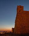
Bordj el Kebir Fortress.
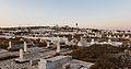
Marine cemetery.
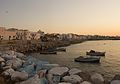
Port of Mahdia.

Slimane Hamza Mosque.

Mahida in night.
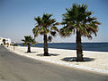
Mahida beach.

Old port.
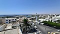
Aerial view of Mahida.


See also[]
- European enclaves in North Africa before 1830
- Mahdia shipwreck
- List of cities in Tunisia
References[]
- ^ "Aphrodisium, which is now commonly called Africa, but by the Moors Mahdia" (Antique Map of Tunis, Mahdia & Peñon de Veles by Braun & Hogenberg
- ^ Fiche technique des sites archéologiques de Mahdia
- ^ Geographical Names: Cape Africa: Tunisia
- ^ Satellite view of Cape Africa
- ^ Kenneth Meyer Setton, The Papacy and the Levant, 1204-1571 (American Philosophical Society 1984 ISBN 978-0-87169161-3), p. 533
- ^ Jump up to: a b Charles Tissot, Géographie comparée de la province romaine d'Afrique (Paris 1888), p. 176
- ^ Annuario Pontificio 2013 (Libreria Editrice Vaticana 2013 ISBN 978-88-209-9070-1), p. 838
- ^ J.P. Mesnage, L'Afrique chrétienne, Paris 1912, p. 114
- ^ Favreau, Robert (1995) Etudes d'epigraphie medievale: recueil d'articles de Robert Favreau rassemblés à l'occasion de son départ à la retraite Pulim, Limoges, page 357, footnote 113; in French
- ^ Sophrone Pétridès, "Ruspe" in Catholic Encyclopedia (New York 1912)
- ^ Annuario Pontificio 2013 (Libreria Editrice Vaticana 2013 ISBN 978-88-209-9070-1), p. 961
- ^ "Mahdia: Historical Background". Commune-mahdia.gov.tn. Archived from the original on 2013-11-09. Retrieved 2012-07-15.
- ^ Fuller, J.F.C., A Military History of the Western World, Volume I, Da Capo Press, 1987, p. 408 ISBN 0-306-80304-6
- ^ Abela, Joe. "Claude de la Sengle (1494 - 1557)". Senglea Local Council. Retrieved 5 October 2014.
- ^ Weisel, Eva (27 December 2011). "Honoring All Who Saved Jews". The New York Times. Retrieved 12 June 2017.
- ^ "Banlieue de Sahel". Société Nationale des Chemins de Fer Tunisiens. Retrieved 2 April 2015.
- ^ "Les normales climatiques en Tunisie entre 1981 2010" (in French). Ministère du Transport. Archived from the original on 19 December 2019. Retrieved 3 January 2020.
- ^ "Données normales climatiques 1961-1990" (in French). Ministère du Transport. Archived from the original on 21 December 2019. Retrieved 3 January 2020.
- ^ "Les extrêmes climatiques en Tunisie" (in French). Ministère du Transport. Archived from the original on 21 December 2019. Retrieved 3 January 2020.
- ^ "Réseau des stations météorologiques synoptiques de la Tunisie" (in French). Ministère du Transport. Retrieved 3 January 2020.
Notes[]
External links[]
| Wikimedia Commons has media related to Mahdia. |
- tourismtunisia.com (in English)
- LookLex / Tunisia
- Mahdia Portal
- . Encyclopædia Britannica (11th ed.). 1911.
| show |
|---|
| show Authority control |
|---|
- Mahdia
- 921 establishments
- Populated places established in the 10th century
- Cities in Tunisia
- Mediterranean port cities and towns in Tunisia
- Communes of Tunisia
- Fatimid architecture
- Populated places in Mahdia Governorate
- 10th-century establishments in Ifriqiya
- Fatimid cities
- 10th-century establishments in the Fatimid Caliphate