Mainburg
show This article may be expanded with text translated from the corresponding article in German. (March 2009) Click [show] for important translation instructions. |
Mainburg | |
|---|---|
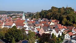 City center of Mainburg | |
 Coat of arms | |
show Location of Mainburg within Kelheim district | |
 Mainburg | |
| Coordinates: 48°39′N 11°47′E / 48.650°N 11.783°ECoordinates: 48°39′N 11°47′E / 48.650°N 11.783°E | |
| Country | Germany |
| State | Bavaria |
| Admin. region | Niederbayern |
| District | Kelheim |
| Government | |
| • Mayor (2020–26) | Helmut Fichtner[1] (FW) |
| Area | |
| • Total | 61.59 km2 (23.78 sq mi) |
| Elevation | 422 m (1,385 ft) |
| Population (2020-12-31)[2] | |
| • Total | 15,106 |
| • Density | 250/km2 (640/sq mi) |
| Time zone | UTC+01:00 (CET) |
| • Summer (DST) | UTC+02:00 (CEST) |
| Postal codes | 84042–84048 |
| Dialling codes | 08751 |
| Vehicle registration | KEH, MAI, PAR, RID, ROL |
| Website | www.mainburg.de |


Mainburg is a town in the district of Kelheim, in Bavaria, Germany. It is situated on the river Abens, 30 km northwest of Landshut and 30 km southeast of Ingolstadt.
Mainburg borders four communities; Aiglsbach, Elsendorf, Attenhofen, and Volkenschwand. The town has 15,163 residents, the third largest in its district.[3]

Town Hall on the market square
References[]
- ^ Liste der ersten Bürgermeister/Oberbürgermeister in kreisangehörigen Gemeinden, Bayerisches Landesamt für Statistik, 15 July 2021.
- ^ "Tabellenblatt "Daten 2", Statistischer Bericht A1200C 202041 Einwohnerzahlen der Gemeinden, Kreise und Regierungsbezirke". Bayerisches Landesamt für Statistik (in German). June 2021.
- ^ "Spreadsheet "Data 2", Statistical Report A1200C 202041 Population of the municipalities, districts and administrative districts 1st quarter, 2020". Retrieved 2021-01-27.
| show Towns and municipalities in Kelheim (district) |
|---|
This Kelheim district location article is a stub. You can help Wikipedia by . |
| show Authority control |
|---|
Categories:
- Towns in Bavaria
- Lower Bavaria geography stubs