Malše
| Malše Maltsch | |
|---|---|
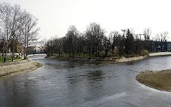 Confluence of the Malše and Vltava rivers in České Budějovice | |
| Location | |
| Countries | |
| State (AT) | Upper Austria |
| Region (CZ) | South Bohemian |
| Physical characteristics | |
| Source | |
| • location | Near Sandl, Bezirk Freistadt, Upper Austria |
| • elevation | 985 m (3,232 ft) |
| Mouth | |
• location | Vltava river in České Budějovice |
• coordinates | 48°58′22″N 14°28′12″E / 48.97278°N 14.47000°ECoordinates: 48°58′22″N 14°28′12″E / 48.97278°N 14.47000°E |
• elevation | 385 m (1,263 ft) |
| Length | 96 km (60 mi) |
| Basin size | 979.1 km2 (378.0 sq mi) |
| Discharge | |
| • average | 7.26 m3/s (256 cu ft/s) |
| Basin features | |
| Progression | Vltava→ Elbe→ North Sea |

The Malše (German: Maltsch) is a river in Upper Austria and in the Czech Republic, a right tributary of the Vltava.
The Malše originates on the north slope of the , near the village of Sandl in Freistadt District, Upper Austria. It flows northward and forms 22 kilometres (14 mi) of Austria-Czech border before fully entering the Český Krumlov District of South Bohemian Region near Dolní Dvořiště. Other communities along the Malše include Rychnov nad Malší, Kaplice, Římov, and Doudleby.
In the city of České Budějovice, the Malše joins the Vltava.
References[]
| Wikimedia Commons has media related to Malše. |
| hide Authority control | |
|---|---|
| General | |
| National libraries | |
This South Bohemian Region location article is a stub. You can help Wikipedia by . |
Categories:
- Tributaries of the Vltava
- Rivers of the South Bohemian Region
- Rivers of Upper Austria
- International rivers of Europe
- Austria–Czech Republic border
- Rivers of Austria
- Border rivers
- South Bohemian Region geography stubs
- Czech Republic river stubs
- Austria river stubs