Malda, West Bengal
This article needs additional citations for verification. (December 2012) |
Malda
Merged City of Old Malda and English Bazar Municipalities | |
|---|---|
City | |
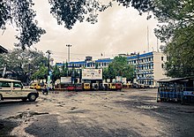
 Malda City Skyline view | |
| Nickname(s): Mango City | |
 Malda Location in West Bengal, India | |
| Coordinates: 25°00′43″N 88°08′36″E / 25.0119°N 88.1433°ECoordinates: 25°00′43″N 88°08′36″E / 25.0119°N 88.1433°E | |
| Country | |
| State | |
| District | Malda |
| Division | Malda |
| Railway Station | Malda Town railway station |
| Total Wards | 49 |
| Government | |
| • Type | Municipality |
| • Body | English Bazar Municipality Old Malda Municipality |
| • Chairman | Sumala Agarwala |
| • Chairman | Basistha Trivedi |
| Area | |
| • City | 13.25 km2 (5.12 sq mi) |
| • Urban | 22.79 km2 (8.80 sq mi) |
| • Metro | 81 km2 (31 sq mi) |
| Elevation | 17 m (56 ft) |
| Population (2011)[3] | |
| • City | 216,083 |
| • Rank | 6th in West Bengal |
| • Density | 16,000/km2 (42,000/sq mi) |
| • Urban | 300,088 |
| • Metro | 324,237 |
| Demonym(s) | Maldabasi |
| Languages | |
| • Official | Bengali[4][5] |
| • Additional official | English[4] |
| Time zone | UTC+5:30 (IST) |
| PIN | 732101, 732102, 732103, 732141, 732142, 732128 |
| Telephone code | 91-3512-2xxxxx |
| Vehicle registration | WB-65/WB-66 |
| Lok Sabha constituency | Maldaha Uttar, Maldaha Dakshin |
| Vidhan Sabha constituency | Malda, English Bazar |
| River | Mahananda River |
| Website | www |


Malda is a city in the Indian state of West Bengal. It is the sixth largest city (urban agglomeration) in West Bengal.[6] It is the headquarters of the Malda district as well as of the Malda division of West Bengal. It consists of two municipalities, viz. English Bazar Municipality and Old Malda Municipality, under English Bazar Metropolitan Area. The city is located on the banks of the Mahananda River. Malda was an undeveloped city which was enlarging from 1925 to 1930. The city is growing rapidly nowadays with its population inching towards half a million.
Civic administration[]
There are two municipalities in Malda, i.e. the English Bazar Municipality and the Old Malda Municipality.
The municipality of English Bazar is divided into 29 wards. The Trinamool Congress with 15 councillors holds the power in this municipality (as of 2015).
The municipality of Old Malda is divided into 20 wards.[7]
Demographics[]
As of the 2011 census, Malda metropolitan city had a total population of 324,237.[8]
As of the 2011 census, English Bazar municipality had a population of 216,083.[3] The municipality had a sex ratio of 877 females per 1,000 males and 14.9% of the population were under six years old.[3] Effective literacy was 84.69%; male literacy was 85.44% and female literacy was 83.86%.[3]
As of 2001 India census,[9] Old Malda Municipality had a population of 62,944. Males constitute 52% of the population and females 48%. Old Malda has an average literacy rate of 61%, higher than the national average of 59.5%: male literacy is 67%, and female literacy is 54%. In Old Malda, 15% of the population is under 6 years of age.
Geography[]
Location[]
Malda is located at 25°00′43″N 88°08′36″E / 25.0119°N 88.1433°E.[10] It has an average elevation of 17 metres (56 feet). It is situated on both the western and eastern banks of the river Mahananda.
Climate[]
Like the most other places in West Bengal, the weather of Malda is usually extremely humid and tropical. Temperatures can reach as high as 42 °C (108 °F) during the day in May and June and fall as low as 8 °C (46 °F) overnight in December and January. Malda's highest recorded temperature was 45.0 °C (113.0 °F) on 27 May 1958 and lowest recorded temperature was 3.9 °C (39.0 °F) on 3 February 1905.
In Malda, the average annual temperature is 26.4 °C (79.5 °F). Precipitation is about 1,554 mm (61.2 in) per year. The driest month is December. There is 4.3 mm (0.17 in) of precipitation in December. The greatest amount of precipitation occurs in July, with an average of 352 mm (13.9 in).

| hide | |||||||||||||
|---|---|---|---|---|---|---|---|---|---|---|---|---|---|
| Month | Jan | Feb | Mar | Apr | May | Jun | Jul | Aug | Sep | Oct | Nov | Dec | Year |
| Record high °C (°F) | 32.5 (90.5) |
37.8 (100.0) |
41.7 (107.1) |
44.1 (111.4) |
45.0 (113.0) |
44.4 (111.9) |
38.7 (101.7) |
40.0 (104.0) |
40.9 (105.6) |
40.5 (104.9) |
34.4 (93.9) |
31.7 (89.1) |
45.0 (113.0) |
| Mean maximum °C (°F) | 27.9 (82.2) |
32.2 (90.0) |
37.8 (100.0) |
40.7 (105.3) |
40.6 (105.1) |
39.3 (102.7) |
36.1 (97.0) |
35.9 (96.6) |
35.6 (96.1) |
34.6 (94.3) |
32.7 (90.9) |
29.3 (84.7) |
42.1 (107.8) |
| Average high °C (°F) | 24.2 (75.6) |
28.2 (82.8) |
33.3 (91.9) |
36.2 (97.2) |
35.6 (96.1) |
34.4 (93.9) |
32.5 (90.5) |
32.7 (90.9) |
32.5 (90.5) |
31.9 (89.4) |
30.0 (86.0) |
26.3 (79.3) |
31.5 (88.7) |
| Average low °C (°F) | 12.2 (54.0) |
15.3 (59.5) |
19.3 (66.7) |
23.0 (73.4) |
24.8 (76.6) |
26.0 (78.8) |
26.3 (79.3) |
26.4 (79.5) |
25.9 (78.6) |
23.7 (74.7) |
19.1 (66.4) |
14.2 (57.6) |
21.4 (70.5) |
| Mean minimum °C (°F) | 8.9 (48.0) |
11.5 (52.7) |
15.2 (59.4) |
18.7 (65.7) |
20.6 (69.1) |
23.0 (73.4) |
23.8 (74.8) |
24.2 (75.6) |
23.5 (74.3) |
20.5 (68.9) |
15.3 (59.5) |
11.0 (51.8) |
8.7 (47.7) |
| Record low °C (°F) | 4.1 (39.4) |
3.9 (39.0) |
7.2 (45.0) |
11.1 (52.0) |
13.7 (56.7) |
18.0 (64.4) |
18.5 (65.3) |
19.3 (66.7) |
17.9 (64.2) |
11.7 (53.1) |
8.3 (46.9) |
5.0 (41.0) |
3.9 (39.0) |
| Average rainfall mm (inches) | 10.4 (0.41) |
12.3 (0.48) |
16.6 (0.65) |
41.7 (1.64) |
129.5 (5.10) |
240.3 (9.46) |
352.0 (13.86) |
307.1 (12.09) |
308.1 (12.13) |
119.9 (4.72) |
12.0 (0.47) |
4.3 (0.17) |
1,554.3 (61.19) |
| Average rainy days | 0.8 | 1.3 | 1.4 | 2.7 | 6.3 | 11.2 | 15.3 | 14.4 | 12.8 | 4.7 | 0.6 | 0.7 | 72.0 |
| Average relative humidity (%) (at 17:30 IST) | 63 | 54 | 47 | 51 | 58 | 69 | 75 | 74 | 76 | 71 | 65 | 65 | 64 |
| Source: India Meteorological Department[11][12][13] | |||||||||||||
Transport[]
Road[]

![]() NH 12 crosses through the city. The Gour Kanya Bus Terminus serves as the bus depot for both private buses and government bus service operated by the North Bengal State Transport Corporation (NBSTC).
NH 12 crosses through the city. The Gour Kanya Bus Terminus serves as the bus depot for both private buses and government bus service operated by the North Bengal State Transport Corporation (NBSTC).
Rail[]

There are four railway stations which serves the metropolitan city. The Malda Town railway station serves the English Bazar area; the Old Malda Junction railway station serves the Old Malda area; the serves Mangalbari and Naldubi area, and the Gour Malda railway station serves Mahadipur and Gauḍa (Gour) area.
Air[]
Malda Airport (IATA: LDA, ICAO: VEMH) was closed in 1972 due to the Bangladesh War. Before that there were direct daily flights from Malda to Kolkata, Delhi, and Guwahati. In 2014, direct helicopter services were started between Malda and Kolkata, by the government of West Bengal. As of 2017, the airport is under construction and the flight service will start very soon.
Religion[]
As of 2011 census, the majority of the population of the English Bazar municipality were Hindus with 86.95% adherents, followed by 11.02% Muslims and small populations of Sikhs and Christians.[14]
Education[]

University[]
- The University of Gour Banga, established in 2008. Almost all the 28 colleges in Malda, Dakshin Dinajpur and Uttar Dinajpur districts (except for Raiganj University College), are affiliated with it.
Colleges[]
- General degree colleges
- Malda College
- Gour Mahavidyalaya
- Malda Women's College
- Engineering colleges
- Ghani Khan Choudhury Institute of Engineering & Technology (GKCIET)
- IMPS College of Engineering and Technology

- Polytechnic colleges
- Malda Polytechnic
- Medical colleges
Schools[]
Some of the notable high schools of the city include
- Boys' high schools

- A. C. Institution
- Lalit Mohan Shyam Mohini High School
- Malda Town High School
- Malda Zilla School
- Ramakrishna Mission Vivekananda Vidyamandir
- Girls' high schools
- Barlow Girls' High School
- Malda C C Girls' High School
- Rail schools
- Malda Railway High School
- English medium schools
- Holy Child English Academy
Notable people[]
- A. B. A. Ghani Khan Choudhury - (1927 – 2006) politician and a senior leader of the Indian National Congress party.
- Benoy Kumar Sarkar - (1887-1949) Indian social scientist, professor, nationalist and founder of several institutes in Kolkata.
- Subhash Bhowmick - born in Malda West Bengal is a retired Indian football international player and club level coach and manager.
- Subhamita Banerjee - Bengali singer who specializes in modern songs, Ghazals.
- Mausam Noor
- Sukhendu Sekhar Roy
- Sabina Yeasmin
- Nihar Ranjan Ghosh
- Krishnendu Narayan Choudhury
See also[]
- English Bazar (community development block)
- Malda Museum
- List of cities in West Bengal
- List of metropolitan area in West Bengal
References[]
- ^ "English Bazar Municipality".
- ^ Jump up to: a b "Old Malda Municipality".
- ^ Jump up to: a b c d "Provisional Population Totals, Census of India 2011; Cities having population 1 lakh and above" (PDF). Office of the Registrar General & Census Commissioner, India. Retrieved 27 March 2012.
- ^ Jump up to: a b "Fact and Figures". www.wb.gov.in. Retrieved 15 January 2019.
- ^ "52nd Report of the Commissioner for Linguistic Minorities in India" (PDF). nclm.nic.in. Ministry of Minority Affairs. p. 85. Archived from the original (PDF) on 25 May 2017. Retrieved 15 January 2019.
- ^ "Urban Agglomerations/Cities having population 1 lakh and above" (PDF). Provisional Population Totals, Census of India 2011. Retrieved 10 October 2011.
- ^ "Battle of couples in Malda civic polls | Kolkata News - Times of India". The Times of India.
- ^ "Provisional Population Totals, Census of India 2011; Urban Agglomerations/Cities having population 1 lakh and above" (PDF). Office of the Registrar General & Census Commissioner, India. Retrieved 27 March 2012.
- ^ "Census of India 2001: Data from the 2001 Census, including cities, villages and towns (Provisional)". Census Commission of India. Archived from the original on 16 June 2004. Retrieved 1 November 2008.
- ^ "Maps, Weather, and Airports for Ingraj Bazar,India". fallingrain.com.
- ^ "Station: Malda, Climatological Table 1981–2010" (PDF). Climatological Normals 1981–2010. India Meteorological Department. January 2015. pp. 465–466. Archived from the original (PDF) on 5 February 2020. Retrieved 10 January 2021.
- ^ "Climate for Malda city". Retrieved 19 October 2020.
- ^ "Extremes of Temperature & Rainfall for Indian Stations (Up to 2012)" (PDF). India Meteorological Department. December 2016. p. M238. Archived from the original (PDF) on 19 October 2020. Retrieved 19 October 2020.
- ^ "C-1 Population By Religious Community". census.gov.in. Retrieved 27 December 2020.
Further reading[]
- Chakrabarti D.K. (1992). Notes on the archaeology of Maldaha and West Dinajpur districts, West Bengal. South Asian Studies, 9:pp. 123–135
External links[]
![]() Gour-Pandua travel guide from Wikivoyage
Gour-Pandua travel guide from Wikivoyage
| show Cities, towns and locations in Malda district, Malda division |
|---|

| show |
|---|
- Cities and towns in Malda district
- Maldah