Manchester (Pittsburgh)
Manchester | |
|---|---|
 Liverpool Street in Manchester | |
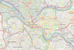
 Location of Manchester in Pittsburgh | |
| Coordinates: 40°27′18″N 80°1′30″W / 40.45500°N 80.02500°WCoordinates: 40°27′18″N 80°1′30″W / 40.45500°N 80.02500°W | |
| Country | |
| State | |
| City | |
| Area | |
| • Total | 0.72 km2 (0.279 sq mi) |
| Population | |
| • Total | 2,130 |
| • Density | 2,900/km2 (7,600/sq mi) |
Manchester Historic District | |
U.S. National Register of Historic Places | |
U.S. Historic district | |
 | |
| Area | 51.6 acres (20.9 ha). Irregular pattern contained with Faulsey, Chateau, Franklin, and Bidwell Streets. |
| Architectural style | Late Victorian |
| NRHP reference No. | 75001611[2] |
| Significant dates | |
| Added to NRHP | September 18, 1975 |
| Designated CPHD | July 30, 1979[3] |
| Designated PHLF | 1976[4] |


Manchester is a neighborhood on Pittsburgh, Pennsylvania's North Side. It has a ZIP code of 15233, and has representation on Pittsburgh City Council by the council member for District 6 (Northshore/Downtown Neighborhoods). Manchester houses PBF Battalion 1 & 37 Engine, and is covered by PBP Zone 1 and the Bureau of EMS Medic 4. The neighborhood includes the Manchester Historic District, which protects, to some degree, 609 buildings over a 51.6-acre (20.9 ha) area. The district was listed on the National Register of Historic Places in 1975.[2]
History[]
Manchester began as a village along the shore of the river, providing supplies and services to the surrounding farms. On November 2, 1843, by act of the Pennsylvania Assembly, the borough of Manchester was created out of the surrounding Ross Township.[5] By 1868 there was a well-used wharf in the borough that needed repair.[6] On 12 March 1867, the State Legislature enacted a statute to allow Allegheny City to annex the Borough of Manchester, adding a 9 April 1867 supplement to also annex the southern portions of M'Clure and Reserve townships.[7][8] Until 1907, Manchester was a ward of Allegheny, Pennsylvania. Thereafter it is a neighborhood of Pittsburgh with boundaries that are still clearly known.
Geography[]
The Manchester Historic District is Pittsburgh's largest historic district under the National Register of Historic Places, preserved for its early 19th century-built Late Victorian-style houses.
Manchester was rated as one of the top 10 neighborhoods for "being close to everything" because it's walkable and has easy access to public transportation and major roadways.
The Three Rivers Heritage Trail System runs along Manchester.
Demographics[]
Manchester is almost exclusively residential. As of the 2010 Census, there were 2,130 people residing in Manchester. According to a report created by the University Center for Social and Urban Research, 46.3% of houses were families while 55.7% were nonfamily households. The median sales price for homes in Manchester for Nov 12 to Jan 13 was $172,350. This represents an increase of 36.8%, or $46,350, compared to the prior quarter and an increase of 48.6% compared to the prior year. Sales prices have appreciated 94.7% over the last 5 years in Manchester, Pittsburgh. The median sales price of $172,350 for Manchester is 29.68% higher than the median sales price for Pittsburgh PA. Average price per square foot for homes in Manchester was $54 in the most recent quarter, which is 43.75% lower than the average price per square foot for homes in Pittsburgh.
Education[]
Manchester's schools are within the Pittsburgh Public School District.[9]
Surrounding Pittsburgh neighborhoods[]
- Allegheny West
- California-Kirkbride
- Central Northside
- Chateau
- Marshall-Shadeland
Gallery[]

Anderson Manor, built circa 1830, at 1423 Liverpool Street.
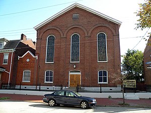
(formerly the ), built in 1865, located at 1437 Juniata Street.

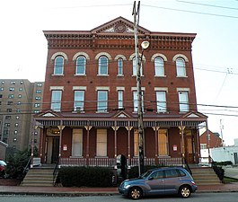
(formerly ), built in 1867, located at 1304 Manhattan Street.
Hoene-Werle House, built in 1887, at 1313–1315 Allegheny Avenue.
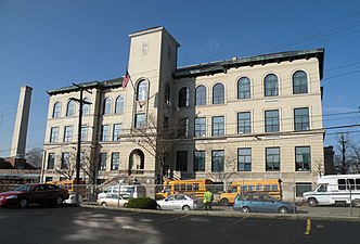
Conroy Junior High School (also known as Conroy Education Center), built in 1936, at the corner of Page and Fulton Streets.

Manchester, as seen from the West End Overlook.

West facing view of Liverpool Street


See also[]
References[]
- ^ Jump up to: a b "PGHSNAP 2010 Raw Census Data by Neighborhood". Pittsburgh Department of City Planning [PGHSNAP Utility]. 2012. Retrieved 24 June 2013.
- ^ Jump up to: a b "NPS Focus". National Register of Historic Places. National Park Service. Retrieved April 27, 2010.
- ^ "Local Historic Designations". Pittsburgh: Pittsburgh History & Landmarks Foundation. Retrieved 2011-08-09.
- ^ Historic Landmark Plaques 1968-2009 (PDF). Pittsburgh, PA: Pittsburgh History & Landmarks Foundation. 2010. Retrieved 2011-08-05.
- ^ Atlas of the county of Allegheny, Pennsylvania. Philadelphia: G. M. Hopkins. 1876. p. 4.
- ^ The Legislative Record: Containing the Debates and Proceedings of the Pennsylvania Legislature, Pennsylvania General Assembly, pub. 1868. Page 117. Accessed 6 October 2019.
- ^ Laws of the General Assembly of the Commonwealth of Pennsylvania, Pennsylvania, 1867. Page 409. Accessed 6 October 2019.
- ^ Allegheny City: A History of Pittsburgh’s North Side, by Dan Rooney and Carol Peterson. University of Pittsburgh Press, 2013. Page 130. Accessed 6 October 2019.
- ^ "Pittsburgh Public Schools". Archived from the original on 14 January 2013. Retrieved 8 February 2013.
External links[]
| Wikimedia Commons has media related to Manchester (Pittsburgh). |
- Interactive Pittsburgh Neighborhoods Map
- Manchester Historic Society
- Manchester Citizen's Corporation
- Mexican War Streets Society
- Carnegie Science Center
- Carnegie Library of Pittsburgh
- Manchester Craftmen's Guild
- City Council District 6
- Manchester Youth Development Center
| show US National Register of Historic Places in Pennsylvania |
|---|

| show Authority control |
|---|
- Historic districts in Pittsburgh
- Neighborhoods in Pittsburgh
- City of Pittsburgh historic designations
- Pittsburgh History & Landmarks Foundation Historic Landmarks
- Historic districts on the National Register of Historic Places in Pennsylvania
- National Register of Historic Places in Pittsburgh