Mandritsara (district)
Mandritsara District | |
|---|---|
District | |
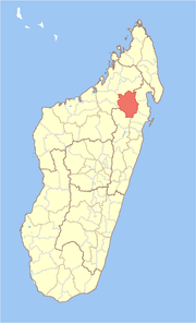 Location in Madagascar | |
| Coordinates: 16°18′S 48°59′E / 16.300°S 48.983°E | |
| Country | |
| Region | Sofia |
| Area | |
| • Total | 10,512 km2 (4,059 sq mi) |
| Population (2001) | |
| • Total | 204,503 |
| • Density | 19.5/km2 (51/sq mi) |
| • Ethnicities | Tsimihety |
| Time zone | UTC3 (EAT) |

Mandritsara is a district in northern Madagascar. It is a part of Sofia Region and borders the districts of Befandriana-Nord in north, Maroantsetra in northeast, in east, Soanierana Ivongo in southeast, Andilamena in south and (Port-Bergé) in west. The area is 10,512 km2 (4,059 sq mi) and the population was estimated to be 204,503 in 2001.[1]
Communes[]
The district is further divided into 22 communes:
- Ambalakirajy
- Ambarikorano
- Ambaripaika
- Ambilombe
- Amboaboa
- Ambodiadabo
- Ambohisoa
- Amborondolo
- Ampatakamaroreny
- Andohajango
- Anjiabe
- Ankiabe Salohy
- Antanambaon'amberina
- Antananadava
- Antsatramidoladola
- Antsirabe Afovoany
- Antsoha
- Kalandy
- Manampaneva
- Mandritsara
- Marotandrano
- Tsaratanana
Nature[]
- Marotandrano Reserve is at 42 km from Mandritsara.
- Part of Makira Natural Park
References and notes[]
- ^ Jump up to: a b "Madagascar Administrative units". Archived from the original on 2009-04-23. Retrieved 2008-02-28.
Coordinates: 16°18′S 48°59′E / 16.300°S 48.983°E
| show Authority control |
|---|

This Sofia Region of Madagascar location article is a stub. You can help Wikipedia by . |
Categories:
- Districts of Sofia Region
- Sofia Region geography stubs