Mandya district
This article possibly contains original research. (November 2017) |
Mandya district | |
|---|---|
District of Karnataka | |
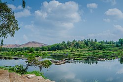 Merger of rivers near Srirangapatna | |
Location in Karnataka | |
| Coordinates: 12°31′N 76°54′E / 12.52°N 76.9°ECoordinates: 12°31′N 76°54′E / 12.52°N 76.9°E | |
| Country | India |
| State | Karnataka |
| Division | Mysore Division |
| Established | 1 July 1939[1] |
| Headquarters | Mandya |
| Talukas | Mandya Malavalli Maddur Nagamangala Krishnarajpet Pandavapura Srirangapatna |
| Government | |
| • Deputy Commissioner | Aswathi S. (IAS) |
| Area | |
| • Total | 4,961 km2 (1,915 sq mi) |
| Population (2011)[3] | |
| • Total | 1,805,769 |
| • Density | 360/km2 (940/sq mi) |
| Languages | |
| • Official | Kannada |
| Time zone | UTC+5:30 (IST) |
| ISO 3166 code | IN-KA-MA |
| Vehicle registration | KA-11,(KA-54 nagamangala) |
| Sex ratio | 1.015 ♂/♀ |
| Literacy | 70.40 % |
| Lok Sabha constituency | Mandya Lok Sabha constituency |
| Climate | Tropical Semi-arid (Köppen) |
| Precipitation | 691 millimetres (27.2 in) |
| Avg. summer temperature | 35 °C (95 °F) |
| Avg. winter temperature | 16 °C (61 °F) |
| Website | mandya |


Mandya District is an administrative district of Karnataka, India. The district is bordered on the south by Mysore and Chamarajangar districts, on the west by Hassan District, on the north by Tumkur District and on the east by Ramanagara district. The district Mandya was carved out of larger Mysore district in the year 1939.
Mandya is the main town in Mandya District. As of 2011, the district population was 1,808,680 (of which 16.03% was urban).[4]
Geography[]
Mandya district is located between north latitude 12°13' to 13°04' N and east longitude 76°19' to 77°20' E.[5] It is bounded by Mysore district to the west and southwest, Tumkur district to the northeast, Chamrajnagar district to the south, Hassan district to the northwest, and Ramanagar district to the east. It has an area of 4,961 square kilometres (1,915 sq mi). The administrative center of Mandya District is Mandya City.
Rivers[]
Mandya District has five rivers: Kaveri River and four tributaries main Hemavathi, Shimsha, Lokapavani, Veeravaishnavi.[6]
Administrative divisions[]

Mandya district consists of 8 taluks grouped under 2 subdivisions. The Mandya subdivision comprises Mandya, Maddur and Malavalli taluks, while the Pandavapura subdivision comprises Pandavapura, Srirangapatna, Nagamangala and Krishnarajpet Taluks.[5]
Economy[]

Since Mandya is located on the banks of the river Cauvery, agriculture is the predominant occupation and the single largest contributor to Mandya's economy . The main crops grown are paddy sugarcane, jowar, maize, cotton, banana, ragi, coconut, pulses, and vegetables.[5]
Transportation[]

Mandya district has an extensive road network. and NH 948 pass through the district. The road network in the district includes 73 kilometres (45 mi) of the National Highways, 467 kilometres (290 mi) of State Highways and 2,968 kilometres (1,844 mi) of major district roads.[7]
Mandya belongs to "South Western Railways" of "Indian Railways". Mandya has many railway stations which are listed below:Mandya railway station. Maddur railway station. Pandavapur railway station. Srirangapattana railway station. BG nagar railway station.[8]
Demographics[]
According to the 2011 census, Mandya district has a population of 1,805,769,[9] roughly equal to the nation of The Gambia[10] or the US state of Nebraska.[11] This gives it a ranking of 263rd in India (out of a total of 640).[9] The district has a population density of 365 inhabitants per square kilometre (950/sq mi) .[9] Its population growth rate over the decade 2001-2011 was 2.55%.[9] Mandya has a sex ratio of 989 females for every 1,000 males,[9] and a literacy rate of 70.14%. Scheduled Castes and Scheduled Tribes make up 14.7% and 1.2% of the population respectively.[9]
| Year | Pop. | ±% p.a. |
|---|---|---|
| 1901 | 482,581 | — |
| 1911 | 504,157 | +0.44% |
| 1921 | 542,421 | +0.73% |
| 1931 | 581,836 | +0.70% |
| 1941 | 634,727 | +0.87% |
| 1951 | 716,583 | +1.22% |
| 1961 | 899,210 | +2.30% |
| 1971 | 1,154,374 | +2.53% |
| 1981 | 1,418,109 | +2.08% |
| 1991 | 1,644,374 | +1.49% |
| 2001 | 1,763,705 | +0.70% |
| 2011 | 1,805,769 | +0.24% |
| source:[12] | ||
Notable people[]
- Ambarish - Kannada film actor, Former Minister Govt of Karnataka, Former Member of Karnataka Legistative Assembly, Former Union Minister, Former Member of Parliament.
- Anasuya Shankar - known as Triveni, a novelist in Kannada language
- Jayalalithaa - 5th Chief Minister of Tamil Nadu, born in Melukote in Pandavapura taluk of Mandya district
- Jayalakshmi Seethapura - folklorist and writer; born in Pandavapura taluk
- S M Krishna - Former Chief Minister of Karnataka, Former Governor of Maharashtra, Former External affairs minister of Govt of India
- Mandya Ramesh - theatre and film actor
- Nagathihalli Chandrashekhar, filmmaker
- H. L. Nagegowda- folklorist, writer, founder of the museum 'Jaanapada loka', born in Nagamangala taluk
- P. T. Narasimhachar - poet from Melukote
- K. S. Narasimhaswamy - Kannada poet, born in Kikkeri, K. R. Pete taluk
- Prem - film director
- C S Puttaraju - Former Minor Irrigation Minister of Karnataka Government, Former Member of Parliament.
- B. S. Ranga - film maker
- Ramya - South Indian actress and the youngest MP of India in the 15th Loksabha
- H. R. Shastry - Veteran actor in Kannada
- Vijaya Narasimha- Kannada film lyricist from Pandavapura taluk
- B.S.Yediyurappa- Karnataka's 25th chief minister
References[]
- ^ "District Profile". Department of State Education Research Andrew Training. Retrieved 6 January 2011.
- ^ "Know India - Karnataka". Government of India. Retrieved 6 January 2011.
- ^ "District Statistics". Official Website of Mandya district. Archived from the original on 21 July 2011. Retrieved 6 January 2011.
- ^ India Census Map Archived 11 January 2010 at the Wayback Machine
- ^ Jump up to: a b c "Ground Water Information Booklet" (PDF). Central Ground Water Board. Retrieved 7 January 2011.
- ^ "Mandya District at a glance". Mandya City Council. Archived from the original on 19 December 2005. Retrieved 10 November 2006.
- ^ "District wise details of road length in Karnataka". Karnataka Public Works Department. Archived from the original on 21 July 2011. Retrieved 9 January 2011.
- ^ [1] Archived 21 July 2011 at the Wayback Machine
- ^ Jump up to: a b c d e f "District Census 2011". Census2011.co.in. 2011. Retrieved 30 September 2011.
- ^ US Directorate of Intelligence. "Country Comparison:Population". Retrieved 1 October 2011.
Gambia, The 1,797,860 July 2011 est.
- ^ "2010 Resident Population Data". U. S. Census Bureau. Archived from the original on 19 October 2013. Retrieved 30 September 2011.
Nebraska 1,826,341
- ^ Decadal Variation In Population Since 1901
External links[]
| Wikimedia Commons has media related to Mandya district. |
| Wikivoyage has a travel guide for Mandya (district). |
- Official website of Mandya district
- Mandya District profile
- Mandya City Council -Mandya District at a glance
| show |
|---|
| show Authority control |
|---|
- Mandya district
- Districts of Karnataka
- 1939 establishments in India