Margosatubig
Margosatubig | |
|---|---|
| Municipality of Margosatubig | |
 | |
 Seal | |
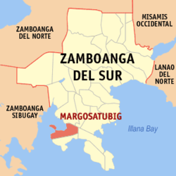 Map of Zamboanga del Sur with Margosatubig highlighted | |
OpenStreetMap  | |
 Margosatubig Location within the Philippines | |
| Coordinates: 7°34′42″N 123°09′57″E / 7.578264°N 123.165914°ECoordinates: 7°34′42″N 123°09′57″E / 7.578264°N 123.165914°E | |
| Country | Philippines |
| Region | Zamboanga Peninsula |
| Province | Zamboanga del Sur |
| District | 2nd district |
| Founded | December 23, 1936 |
| Barangays | 17 (see Barangays) |
| Government | |
| • Type | Sangguniang Bayan |
| • Mayor | George M. Minor |
| • Vice Mayor | Alejandro E. Agua III |
| • Representative | Leonardo L. Babasa Jr. |
| • Municipal Council | Members |
| • Electorate | 21,405 voters (2019) |
| Area | |
| • Total | 111.69 km2 (43.12 sq mi) |
| Elevation | 105 m (344 ft) |
| Highest elevation | 421 m (1,381 ft) |
| Lowest elevation | 0 m (0 ft) |
| Population (2020 census) [3] | |
| • Total | 38,660 |
| • Density | 350/km2 (900/sq mi) |
| • Households | 8,794 |
| Economy | |
| • Income class | 3rd municipal income class |
| • Poverty incidence | 31.13% (2015)[4] |
| • Revenue | ₱144,408,000.00 (2020) |
| • Assets | ₱670,597,000.00 (2020) |
| • Expenditure | ₱97,691,000.00 (2020) |
| • Liabilities | ₱283,482,000.00 (2020) |
| Service provider | |
| • Electricity | Zamboanga del Sur 1 Electric Cooperative (ZAMSURECO 1) |
| Time zone | UTC+8 (PST) |
| ZIP code | 7035 |
| PSGC | |
| IDD : area code | +63 (0)62 |
| Native languages | Subanon Cebuano Chavacano Tagalog |
| Website | www |
Margosatubig, officially the Municipality of Margosatubig (Cebuano: Lungsod sa Margosatubig; Subanen: Benwa Margosatubig; Chavacano: Municipalidad de Margosatubig; Tagalog: Bayan ng Margosatubig), is a 3rd class municipality in the province of Zamboanga del Sur, Philippines. According to the 2020 census, it has a population of 38,660 people. [3]
History[]

The Subanens were believed to be the first people to have settled in this land, right near the swift flowing river that now traverse the Margosatubig Pilot School and Guiwan district. “Malagus Tubig” was the original name of the town, which was taken after the swift river current that kept changing its course towards the mouth of the Dumanquilas Bay. In the 15th century, the Spaniards arrived and found that its bay is a natural refuge from bad weather for their ships. Soon it became their choice settlement changing Malagus Tubig (Marugusaig) to its present name Margosatubig. They built a huge stone fort on top of a hill that served as their bastion against Moro pirates who used to raid the settlements along the Dumanquillas Bay and its vicinity. The fort was known as Cotta Heights. In 1963, it was demolished and is now the site of Pax High School. The Spaniards reigned for years and left as their heritage most evidently, the Chavacano dialect. Suffice it to say that more than a hundred years ago, Margosatubig already existed as a settlement of migrants and natives in the 19th century.
From 1917 to 1936, Margosatubig stayed as a municipal district of the city of Zamboanga. During the Commonwealth Government and by virtue Executive Order No. 17 dated December 23, 1936 signed by President Manuel L. Quezon, Margosatubig finally became a regular and distinct municipality with eight original barrios. It can be said that Margosatubig is the oldest town in Zamboanga del Sur; older even than the undivided Province of Zamboanga.
In 1950, the barrios of Punta Flecha, Pitogo, Qugbay, Balong-balong, Libertad and Dumanguilas were transferred to the newly created town of Dimataling[5]
In 1951, the barrios of Malangas, La Dicha, Diplo, Gusem, Buug, Matinaw, Gaulan, Tinungtungan, Manangon, Lindang, Luop, Silupa, Minsulao, Paruk, Lubing, Balabao, Mali, Baluran, Sampuli and Bacao, all from Margosatubig were separated to form the town of Malangas.[6]
Margosatubig, in spite of being a pioneer town, still remained isolated and reachable only by sea craft. In 1976, it was finally opened to the rest of Zamboanga del Sur by an asphalt road connecting it to Pagadian. This was facilitated by the Zamboanga del Sur Development Project undertaken by the Philippine-Australian Development Assistance Programme (PADAP), and its Electrification by ZAMSURECO-1 followed in 1979.
Climate[]
| Climate data for Margosatubig, Zamboanga del Sur | |||||||||||||
|---|---|---|---|---|---|---|---|---|---|---|---|---|---|
| Month | Jan | Feb | Mar | Apr | May | Jun | Jul | Aug | Sep | Oct | Nov | Dec | Year |
| Average high °C (°F) | 31 (88) |
31 (88) |
32 (90) |
32 (90) |
31 (88) |
30 (86) |
29 (84) |
29 (84) |
29 (84) |
29 (84) |
30 (86) |
31 (88) |
30 (87) |
| Average low °C (°F) | 21 (70) |
21 (70) |
22 (72) |
23 (73) |
24 (75) |
24 (75) |
24 (75) |
24 (75) |
24 (75) |
24 (75) |
23 (73) |
22 (72) |
23 (73) |
| Average precipitation mm (inches) | 22 (0.9) |
18 (0.7) |
23 (0.9) |
24 (0.9) |
67 (2.6) |
120 (4.7) |
132 (5.2) |
156 (6.1) |
119 (4.7) |
124 (4.9) |
54 (2.1) |
24 (0.9) |
883 (34.6) |
| Average rainy days | 9.4 | 9.1 | 11.5 | 11.9 | 20.1 | 22.5 | 22.4 | 23.2 | 21.5 | 22.2 | 15.7 | 11.5 | 201 |
| Source: Meteoblue [7] | |||||||||||||
Barangays[]

Margosatubig is politically subdivided into 17 barangays.
- Balintawak
- Bularong
- Digon
- Guinimanan
- Igat Island
- Josefina
- Kalian
- San Roque (Kolot)
- Limamawan
- Limbatong
- Lumbog
- Magahis
- Poblacion
- Sagua
- Talanusa
- Tiguian
- Tulapok
Demographics[]
| Year | Pop. | ±% p.a. |
|---|---|---|
| 1918 | 7,598 | — |
| 1939 | 23,536 | +5.53% |
| 1948 | 28,587 | +2.18% |
| 1960 | 25,052 | −1.09% |
| 1970 | 34,413 | +3.22% |
| 1975 | 32,309 | −1.26% |
| 1980 | 37,781 | +3.18% |
| 1990 | 28,747 | −2.70% |
| 1995 | 29,597 | +0.55% |
| 2000 | 34,461 | +3.32% |
| 2007 | 34,939 | +0.19% |
| 2010 | 35,596 | +0.68% |
| 2015 | 37,873 | +1.19% |
| 2020 | 38,660 | +0.41% |
| Source: Philippine Statistics Authority [8] [9] [10][11] | ||
Economy[]
| Poverty Incidence of Margosatubig | |
| Source: Philippine Statistics Authority[12][13][14][15][16][17] | |
References[]
- ^ Municipality of Margosatubig | (DILG)
- ^ "2015 Census of Population, Report No. 3 – Population, Land Area, and Population Density" (PDF). Philippine Statistics Authority. Quezon City, Philippines. August 2016. ISSN 0117-1453. Archived (PDF) from the original on May 25, 2021. Retrieved July 16, 2021.
- ^ a b Census of Population (2020). "Region IX (Zamboanga Peninsula)". Total Population by Province, City, Municipality and Barangay. PSA. Retrieved 8 July 2021.
- ^ https://psa.gov.ph/sites/default/files/City%20and%20Municipal-level%20Small%20Area%20Poverty%20Estimates_%202009%2C%202012%20and%202015_0.xlsx; publication date: 10 July 2019; publisher: Philippine Statistics Authority.
- ^ "An act to create the municipality of Dimataling in the province of Zamboanga". LawPH.com. Archived from the original on 2012-07-12. Retrieved 2011-04-09.
- ^ "An Act Creating the Municipality of Malangas in the Province of Zamboanga". LawPH.com. Retrieved 2011-04-09.
- ^ "Margosatubig: Average Temperatures and Rainfall". Meteoblue. Retrieved 1 May 2020.
- ^ Census of Population (2015). "Region IX (Zamboanga Peninsula)". Total Population by Province, City, Municipality and Barangay. PSA. Retrieved 20 June 2016.
- ^ Census of Population and Housing (2010). "Region IX (Zamboanga Peninsula)". Total Population by Province, City, Municipality and Barangay. NSO. Retrieved 29 June 2016.
- ^ Censuses of Population (1903–2007). "Region IX (Zamboanga Peninsula)". Table 1. Population Enumerated in Various Censuses by Province/Highly Urbanized City: 1903 to 2007. NSO.
- ^ "Province of Zamboanga del Sur". Municipality Population Data. Local Water Utilities Administration Research Division. Retrieved 17 December 2016.
- ^ "Poverty incidence (PI):". Philippine Statistics Authority. Retrieved 28 December 2020.
- ^ https://psa.gov.ph/sites/default/files/NSCB_LocalPovertyPhilippines_0.pdf; publication date: 29 November 2005; publisher: Philippine Statistics Authority.
- ^ https://psa.gov.ph/sites/default/files/2003%20SAE%20of%20poverty%20%28Full%20Report%29_1.pdf; publication date: 23 March 2009; publisher: Philippine Statistics Authority.
- ^ https://psa.gov.ph/sites/default/files/2006%20and%202009%20City%20and%20Municipal%20Level%20Poverty%20Estimates_0_1.pdf; publication date: 3 August 2012; publisher: Philippine Statistics Authority.
- ^ https://psa.gov.ph/sites/default/files/2012%20Municipal%20and%20City%20Level%20Poverty%20Estima7tes%20Publication%20%281%29.pdf; publication date: 31 May 2016; publisher: Philippine Statistics Authority.
- ^ https://psa.gov.ph/sites/default/files/City%20and%20Municipal-level%20Small%20Area%20Poverty%20Estimates_%202009%2C%202012%20and%202015_0.xlsx; publication date: 10 July 2019; publisher: Philippine Statistics Authority.
External links[]
| Wikimedia Commons has media related to Margosatubig. |
- Margosatubig Profile at PhilAtlas.com
- Philippine Standard Geographic Code
- Philippine Census Information
Places adjacent to Margosatubig | ||||||||||||||||
|---|---|---|---|---|---|---|---|---|---|---|---|---|---|---|---|---|
| ||||||||||||||||
Pagadian (capital) | |
| Municipalities | |
| Component city | |
| Highly urbanized city |
|
- Municipalities of Zamboanga del Sur