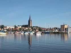
Mariestad
Mariestad | |
|---|---|
 Mariestad | |
 Mariestad | |
| Coordinates: 58°42′N 13°49′E / 58.700°N 13.817°ECoordinates: 58°42′N 13°49′E / 58.700°N 13.817°E | |
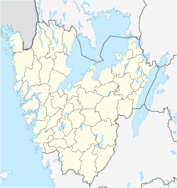
| Country | Sweden |
| Province | Västergötland |
| County | Västra Götaland County |
| Municipality | Mariestad Municipality |
| Area | |
| • Total | 11.76 km2 (4.54 sq mi) |
| Population (31 December 2019)[1] | |
| • Total | 16,611 |
| • Density | 1,413/km2 (3,660/sq mi) |
| Time zone | UTC+1 (CET) |
| • Summer (DST) | UTC+2 (CEST) |


Mariestad (![]() pronunciation) is a locality and the seat of Mariestad Municipality, Västra Götaland County, Sweden. It had 16,611 inhabitants in 2019.[1] Until 1997 it was the capital of the former Skaraborg County and an episcopal see in the Church of Sweden between 1583 and 1646.
pronunciation) is a locality and the seat of Mariestad Municipality, Västra Götaland County, Sweden. It had 16,611 inhabitants in 2019.[1] Until 1997 it was the capital of the former Skaraborg County and an episcopal see in the Church of Sweden between 1583 and 1646.
History[]

The city was founded in 1583 by Duke Charles, who later became King Charles IX of Sweden. The city is named after the his wife Marie of Pfalz. The coat of arms for Mariestad, an ox stepping out of the water, is said to be what Marie of Pfalz saw by the bay of Tidan in Mariestad when she first arrived there.
Diocese[]
Mariestad is one of two Swedish cities with a cathedral without a bishop's seat, the other being Kalmar. For political reasons, the diocese of Mariestad was presided over by a superintendent rather than a bishop from 1583 until 1646, when the superintendent was moved to Karlstad and the diocese of Mariestad was absorbed by that of Skara.
Notable natives[]
- Axel Lindahl (1841–1906), photographer
- Dag Wennlund (born 1963), javelin thrower
- Evelyn Mok (born 1987), actress and comedian
- Helena Andersson
Sports[]
The following sports clubs are located in Mariestad:

Climate[]
| Climate data for Mariestad (1991-2020) | |||||||||||||
|---|---|---|---|---|---|---|---|---|---|---|---|---|---|
| Month | Jan | Feb | Mar | Apr | May | Jun | Jul | Aug | Sep | Oct | Nov | Dec | Year |
| Record high °C (°F) | 10.7 (51.3) |
11.9 (53.4) |
18.3 (64.9) |
27.2 (81.0) |
30.0 (86.0) |
31.0 (87.8) |
34.3 (93.7) |
34.7 (94.5) |
27.2 (81.0) |
22.6 (72.7) |
17.8 (64.0) |
12.5 (54.5) |
34.7 (94.5) |
| Mean maximum °C (°F) | 7.4 (45.3) |
7.4 (45.3) |
12.4 (54.3) |
19.7 (67.5) |
25.3 (77.5) |
27.4 (81.3) |
29.1 (84.4) |
28.0 (82.4) |
22.8 (73.0) |
16.4 (61.5) |
11.4 (52.5) |
8.4 (47.1) |
30.4 (86.7) |
| Average high °C (°F) | 1.7 (35.1) |
1.9 (35.4) |
5.6 (42.1) |
11.6 (52.9) |
17.0 (62.6) |
20.5 (68.9) |
22.8 (73.0) |
21.8 (71.2) |
17.1 (62.8) |
11.0 (51.8) |
6.0 (42.8) |
3.1 (37.6) |
11.7 (53.1) |
| Daily mean °C (°F) | −0.5 (31.1) |
−0.7 (30.7) |
1.9 (35.4) |
6.7 (44.1) |
11.7 (53.1) |
15.5 (59.9) |
17.9 (64.2) |
17.0 (62.6) |
13.0 (55.4) |
7.9 (46.2) |
3.8 (38.8) |
0.8 (33.4) |
7.9 (46.2) |
| Average low °C (°F) | −2.7 (27.1) |
��3.2 (26.2) |
−1.3 (29.7) |
2.6 (36.7) |
7.2 (45.0) |
11.1 (52.0) |
13.7 (56.7) |
13.1 (55.6) |
9.5 (49.1) |
5.2 (41.4) |
1.8 (35.2) |
−1.4 (29.5) |
4.7 (40.5) |
| Mean minimum °C (°F) | −12.0 (10.4) |
−12.1 (10.2) |
−8.5 (16.7) |
−3.4 (25.9) |
1.4 (34.5) |
6.4 (43.5) |
9.7 (49.5) |
8.4 (47.1) |
3.2 (37.8) |
−2.0 (28.4) |
−5.3 (22.5) |
−10.2 (13.6) |
−15.4 (4.3) |
| Record low °C (°F) | −24.4 (−11.9) |
−22.4 (−8.3) |
−20.1 (−4.2) |
−8.2 (17.2) |
−1.5 (29.3) |
3.5 (38.3) |
6.5 (43.7) |
6.0 (42.8) |
−0.1 (31.8) |
−8.5 (16.7) |
−11.8 (10.8) |
−22.2 (−8.0) |
−24.4 (−11.9) |
| Average precipitation mm (inches) | 40.5 (1.59) |
35.5 (1.40) |
28.1 (1.11) |
35.3 (1.39) |
48.4 (1.91) |
72.8 (2.87) |
72.4 (2.85) |
72.2 (2.84) |
53.2 (2.09) |
58.2 (2.29) |
50.9 (2.00) |
46.7 (1.84) |
614.2 (24.18) |
| Source: SMHI Open Data[2] | |||||||||||||
References[]
| Wikimedia Commons has media related to Mariestad. |
| Wikivoyage has a travel guide for Mariestad. |
- ^ a b c "Folkmängd och landareal i tätorter, per tätort. Vart femte år 1960 - 2019" (in Swedish). Statistics Sweden. 24 March 2020. Retrieved 13 December 2020.
- ^ https://www.smhi.se/data/meteorologi/ladda-ner-meteorologiska-observationer#param=airTemperatureMinAndMaxOnceEveryDay,stations=all,stationid=83440
Authority control | |
|---|---|
| General | |
| National libraries | |
| Other |
|
This article about a location in Västra Götaland County, Sweden is a stub. You can help Wikipedia by . |
- Populated lakeshore places in Sweden
- Populated places in Västra Götaland County
- Populated places in Mariestad Municipality
- Municipal seats of Västra Götaland County
- Swedish municipal seats
- Populated places established in 1583
- Västra Götaland County geography stubs