Marktl
Marktl | |
|---|---|
 Marktl am Inn | |
 Coat of arms | |
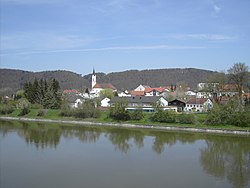
show Location of Marktl within Altötting district | |
 Marktl | |
| Coordinates: 48°15′12″N 12°50′35″E / 48.25333°N 12.84306°ECoordinates: 48°15′12″N 12°50′35″E / 48.25333°N 12.84306°E | |
| Country | Germany |
| State | Bavaria |
| Admin. region | Oberbayern |
| District | Altötting |
| Municipal assoc. | Marktl |
| Subdivisions | 63 Gemeindeteile |
| Government | |
| • Mayor (2020–26) | Benedikt Dittmann[1] |
| Area | |
| • Total | 27.84 km2 (10.75 sq mi) |
| Elevation | 364 m (1,194 ft) |
| Population (2020-12-31)[2] | |
| • Total | 2,790 |
| • Density | 100/km2 (260/sq mi) |
| Time zone | UTC+01:00 (CET) |
| • Summer (DST) | UTC+02:00 (CEST) |
| Postal codes | 84533 |
| Dialling codes | 08678 |
| Vehicle registration | AÖ |
| Website | www.marktl.de |


Marktl, or often unofficially called Marktl am Inn ("Little market on the river Inn"), is a village and historic market municipality in the state of Bavaria, Germany, near the Austrian border, in the Altötting district of Upper Bavaria. The most notable neighbouring town is Altötting. Marktl has approximately 2,700 inhabitants.
Marktl is the birthplace of Pope Benedict XVI (previously Cardinal Joseph Aloisius Ratzinger), who succeeded Pope John Paul II as the 265th head of the Roman Catholic Church. In 2013 he abdicated and was succeeded by Pope Francis.
History[]
- 13th century - Established as the power base of the .
- 1297 - Construction of the first church dedicated to Saint Oswald within the diocese of Stammham, it was sponsored by and was consecrated by Bishop .
- 1422 - Duke Henry XVI of Bavaria grants market privileges to the town.
- 1477 - Duke Louis the Rich grants a coat of arms to the citizens of Marktl, showing a ship hook and caper measure, as symbols of navigation and trade
- 1577 - Duke Albert V permits that the assignment of a priest to the Marktl branch church
- 1697 - Prince-Elector Max Emanuel arranges the construction of the first bridge across the river Inn at Marktl
- 1701 - Lightning hits the tower of Saint Oswald church, which results in the incineration of the whole market
- 1851 - Marktl, which had been only a subsidiary of the parish of Stammham, becomes an independent parish
- 1857 - Bishop consecrates the newly built parish church of Saint Oswald
- 1871 - Marktl gets a railway station when the railway line from Munich to Simbach is built
- 1919 - Construction of a protective dam on the Inn River as a safeguard against constant flooding
- 1927 - Completion of the first concrete bridge over the Inn and construction of the "Neue Strasse" (New Street) to bypass the market
- 1965 - Remodel of parish church at Saint Oswald; parish hall is built
- 1970-1972 - The formerly independent municipalities of and are incorporated into Marktl
- 1980 - A mechanical-biological purification plant is built
- 1981-1983 - The Bürgerhaus ("Citizens' House") is built (includes a public library, rooms for events, a skittles alley etc.)
- 1984-1987 - Construction of fire-brigade stations in Marktl and Marktlberg
- 1989 - Connection to Autobahn A 94
- 1996 - Redesign of the market square
- 2000 - Redesign of the square in front of the railway station
- 2005 - Election of Pope Benedict XVI and bottling of commemorative "Papstbier" (Pope bier) by local brewer Weideneder for sale to the public
- 2006 - Visit of Pope Benedict XVI
Notable people[]
- Georg Lankensperger (* 1779; † 1847), cartwright
- Paul Devrient (* 1890; † 1973), opera tenor and director
- Hugo Grau (* 1899; † 1984), veterinary
- Benedictus XVI (* 1927 as Joseph Aloisius Ratzinger), 265th Pope
- (* 1982), cabaret dancer and writer
Coat of arms[]
Marktl's coat of arms features a ship's hook and caper measure as symbols of navigation and trade, under the blue and white lozenges of the duchy of Bavaria.
Twin towns — sister cities[]
Marktl is twinned with:
 Wadowice, Poland (2006)
 Gönnheim, Germany
 Sotto il Monte Giovanni XXIII, Italy (2009)
References[]
- ^ Liste der ersten Bürgermeister/Oberbürgermeister in kreisangehörigen Gemeinden, Bayerisches Landesamt für Statistik, accessed 19 July 2021.
- ^ "Tabellenblatt "Daten 2", Statistischer Bericht A1200C 202041 Einwohnerzahlen der Gemeinden, Kreise und Regierungsbezirke". Bayerisches Landesamt für Statistik (in German). June 2021.
External links[]
| Wikimedia Commons has media related to Marktl. |
- markt-marktl.de Official Homepage
- Marktl am Inn Sleepy Bavarian Village on the World Map.
| show Towns and municipalities in Altötting district |
|---|
| show Authority control |
|---|
Categories:
- Municipalities in Bavaria
- Altötting (district)
- Populated places on the Inn (river)