Töging am Inn
Töging am Inn | |
|---|---|
 Town hall | |
 Coat of arms | |
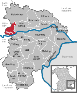
show Location of Töging am Inn within Altötting district | |
 Töging am Inn | |
| Coordinates: 48°15′N 12°34′E / 48.250°N 12.567°ECoordinates: 48°15′N 12°34′E / 48.250°N 12.567°E | |
| Country | Germany |
| State | Bavaria |
| Admin. region | Oberbayern |
| District | Altötting |
| Subdivisions | 9 Gemeindeteile |
| Government | |
| • Mayor (2020–26) | Tobias Windhorst[1] (CSU) |
| Area | |
| • Total | 13.66 km2 (5.27 sq mi) |
| Elevation | 398 m (1,306 ft) |
| Population (2020-12-31)[2] | |
| • Total | 9,249 |
| • Density | 680/km2 (1,800/sq mi) |
| Time zone | UTC+01:00 (CET) |
| • Summer (DST) | UTC+02:00 (CEST) |
| Postal codes | 84513 |
| Dialling codes | 08631 |
| Vehicle registration | AÖ |
| Website | www.toeging.de |


Töging am Inn (Bavarian: Deging am Inn) is a town of 9,382 inhabitants in the district of Altötting, Upper Bavaria, Germany. It lies on the river Inn.
History[]
Thanks to an artificial water canal, the town is adjacent to a large water power plant, which used to power e.g. an aluminum furnace. Because of many factories in the area, slave workers from the Dachau concentration camp were located nearby during World War II,.[3]
The town hit the news on 7 February 2006, when the roof of the local Netto supermarket collapsed. Nobody was hurt in the incident.[1]
References[]
- ^ Liste der ersten Bürgermeister/Oberbürgermeister in kreisangehörigen Gemeinden, Bayerisches Landesamt für Statistik, accessed 19 July 2021.
- ^ "Tabellenblatt "Daten 2", Statistischer Bericht A1200C 202041 Einwohnerzahlen der Gemeinden, Kreise und Regierungsbezirke". Bayerisches Landesamt für Statistik (in German). June 2021.
- ^ Edward Victor.Alphabetical List of Camps, Subcamps and Other Camps.www.edwardvictor.com/Holocaust/List %20 of % 20 camps.htm
External links[]
- Official website
 (in German)
| show Towns and municipalities in Altötting district |
|---|
| show Authority control |
|---|
This Altötting district location article is a stub. You can help Wikipedia by . |
Categories:
- Towns in Bavaria
- Populated places on the Inn (river)
- Upper Bavaria geography stubs