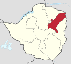
Mashonaland East Province
Mashonaland East | |
|---|---|
 Mashonaland East, Province of Zimbabwe | |
| Country | Zimbabwe |
| Capital | Marondera |
| Area | |
| • Total | 32,230 km2 (12,440 sq mi) |
| Population (2012 census) | |
| • Total | 1,344,955 |
| • Density | 42/km2 (110/sq mi) |
| HDI (2018) | 0.539[1] low · 7th |

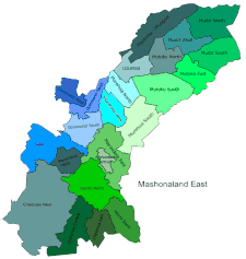
Districts of Mashonaland East
Constituencies
Mashonaland East, informally Mash East, is a province of Zimbabwe. It has an area of 32,230 km2 and a population of approximately 1.35 million (2012). Marondera is the capital of the province.
Geography[]
| show Places adjacent to Mashonaland East Province |
|---|
Districts[]
Mashonaland East is divided into nine districts:
- Chikomba
- Goromonzi
- Marondera
- Mudzi
- Murehwa (Mrehwa)
- Mutoko
- Seke
- Uzumba-Maramba-Pfungwe (UMP)
- Wedza (Hwedza)
Education[]
See also[]
Notes[]
- ^ "Sub-national HDI - Area Database - Global Data Lab". hdi.globaldatalab.org. Retrieved 13 September 2018.
External links[]
- "Base map of Mashonaland East Province" (PDF). United Nations Office for the Coordination of Humanitarian Affairs (OCHA). Archived from the original (PDF) on 19 April 2014.
Coordinates: 17°30′S 32°00′E / 17.500°S 32.000°E

| show Authority control |
|---|
This Zimbabwe location article is a stub. You can help Wikipedia by . |
This article about government in Zimbabwe is a stub. You can help Wikipedia by . |
Categories:
- Mashonaland East Province
- Provinces of Zimbabwe
- Zimbabwe geography stubs
- Zimbabwean government stubs