Matam Region
This article does not cite any sources. (December 2009) |
Matam Region
Région de Matam | |
|---|---|
Region | |
 Location of Matam in Senegal | |
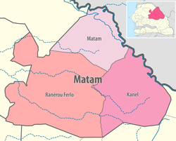 Matam région, divided into 3 départements | |
| Coordinates: 15°06′N 13°38′W / 15.100°N 13.633°WCoordinates: 15°06′N 13°38′W / 15.100°N 13.633°W | |
| Country | Senegal |
| Capital | Matam |
| Départements | List
|
| Area | |
| • Total | 29,445 km2 (11,369 sq mi) |
| Population (2013 census) | |
| • Total | 541,032 |
| • Density | 18/km2 (48/sq mi) |
| Time zone | UTC+0 (GMT) |

Matam is a region of Senegal (regional capitals have the same name as their respective regions).
It is a stark, flat, arid place bounded on the north by the Sénégal River and the south by the Sahelian plain studded with baobab trees. Matam is populated by the tall Pulaar-speaking Toucouleur people who brought Islam to Senegal in the 11th century and gave us the music of Baaba Maal in the 21st century.
Departments[]
Matam region is divided into 3 departments:
- Kanel Département
- Matam Département
- Ranérou Ferlo Département
Geography[]
Matam is traversed by the northwesterly line of equal latitude and longitude.
Cities and Villages[]
See also[]
External links[]
Regions of Senegal | ||
|---|---|---|
This Senegal location article is a stub. You can help Wikipedia by . |
Categories:
- Matam Region
- Regions of Senegal
- Senegal geography stubs