Matty Island
 Matty Island, Nunavut. | |
 Matty Island | |
| Geography | |
|---|---|
| Location | Rae Strait |
| Coordinates | 69°29′N 95°40′W / 69.483°N 95.667°WCoordinates: 69°29′N 95°40′W / 69.483°N 95.667°W |
| Archipelago | Canadian Arctic Archipelago |
| Area | 477 km2 (184 sq mi) |
| Administration | |
| Territory | Nunavut |
| Region | Kitikmeot |
| Demographics | |
| Population | Uninhabited |


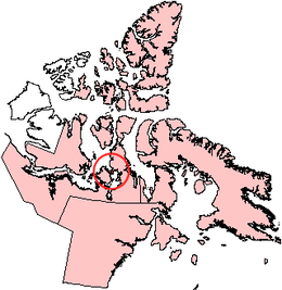
Matty Island is one of the Canadian arctic islands in the Kitikmeot Region, Nunavut. It is located in Rae Strait, between King William Island and the Boothia Peninsula. Located at 69°29'N 95°40'W it has an area of 477 km2 (184 sq mi).[1]
Other islands in the area include Beverly Islands to the south, and Tennent Islands to the west.
References[]
- ^ "The Atlas of Canada - Sea Islands". Natural Resources Canada. Archived from the original on 2010-07-02. Retrieved 2011-05-05.
This Kitikmeot Region, Nunavut location article is a stub. You can help Wikipedia by . |
Categories:
- Islands of Kitikmeot Region
- Uninhabited islands of Kitikmeot Region
- Islands of the Canadian Arctic Archipelago
- Kitikmeot Region, Nunavut geography stubs