Maungaraki
Maungaraki | |
|---|---|
Suburb of Lower Hutt | |
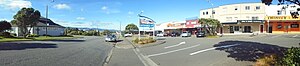 Maungaraki's shopping centre (right) in 2018, with Maungaraki Baptist Church (left) | |
 | |
| Country | New Zealand |
| City | Lower Hutt |
| Electoral ward | Western |
| Established | 1960s |
| Area | |
| • Land | 211 ha (521 acres) |
| Population (2021) | |
| • Total | 4,230 |
| Normandale | ||
|
|
Lower Hutt CBD | |
| Korokoro | Petone | Alicetown |
Maungaraki is a suburb of Lower Hutt. It is one of several Lower Hutt suburbs on the western hills of the Hutt Valley. It contains the largest suburban development on the Hutt Valley's western escarpment[1] that runs along the Wellington Fault.
Maungaraki translated from Māori means "northern mountain".[2] This may reference the Māori pā to the south that once stood at Pito-one.[citation needed]
Features of the suburb[]
The suburb has a shopping centre, a baptist church, and a community hall that is managed by the Maungaraki Community Association. The Church building was relocated from the old NZ Railways works at Moera.
There are two schools in the suburb: Maungaraki School, a full primary school formed in 1999 by the merger of Puketiro and Otonga schools;[3] and Puketiro School, opened in 1967. A former school, Otonga School, opened in 1977; most of the land which Otonga School occupied is now private housing.
Much of Maungaraki falls within Belmont Regional Park, and there are walking tracks from the suburb into the park. Korokoro Dam and its waterfall are both within the park and within Maungaraki.[4][5]
History[]

Housing increased rapidly in the area during the 1960s, at the time it was the largest local-government subdivision in New Zealand.[7]
The main road through the suburb, Dowse Drive, honours the Lower Hutt Mayor Percy Dowse (in office: 1950-1970), who led the development of housing in Maungaraki. Most of the other roads in the suburb feature the names of trees. Reese Jones Grove is named after Thomas and Myrtle Reese Jones, a Korokoro farming couple who sold a proportion of their land in Maungaraki to the Lower Hutt City Council in 1957.
Demographics[]
| Year | Pop. | ±% p.a. |
|---|---|---|
| 2006 | 3,552 | — |
| 2013 | 3,777 | +0.88% |
| 2018 | 3,987 | +1.09% |
| Source: [8] | ||
Maungaraki statistical area covers 2.11 km2 (0.81 sq mi).[9] It had an estimated population of 4,230 as of June 2021,[10] with a population density of 2,005 people per km2.
2018 census data[]
As of the 2018 New Zealand census, the suburb had a sex ratio of 0.98 males per female, and the median age was 37.4 years (compared with 37.4 years nationally). Ethnicities were 74.2% European/Pākehā, 10.2% Māori, 4.3% Pacific peoples, 20.6% Asian, and 2.8% other ethnicities (totals add to more than 100% since people could identify with multiple ethnicities). The proportion of people born overseas was 29.6%, compared with 27.1% nationally. Although some people objected to giving their religion, 50.5% had no religion, 34.1% were Christian, 5.6% were Hindu, 0.9% were Muslim, 1.4% were Buddhist and 2.8% had other religions.
Of those at least 15 years old, 1,110 (35.5%) people had a bachelor or higher degree, and 312 (10.0%) people had no formal qualifications. The median income was $46,200, compared with $31,800 nationally. The employment status of those at least 15 was that 1,866 (59.6%) people were employed full-time, 414 (13.2%) were part-time, and 87 (2.8%) were unemployed.[8]
Education[]
Maungaraki School is a co-educational state primary school for Year 1 to 8 students,[11][12] with a roll of 385 as of November 2021.[13]
External links[]
References[]
- ^ Boffa Miskell (April 2012). "Hutt Landscape Study 2012" (PDF). Hutt City Council. p. 26. Retrieved 11 February 2019.
- ^ "1000 Māori place names". New Zealand Ministry for Culture and Heritage. 6 August 2019.
- ^ "New Zealand Gazette 1998". www.gazette.govt.nz. Retrieved 8 March 2017.
- ^ "Korokoro Dam Waterfall". waterfalls.co.nz. Retrieved 30 November 2021.
- ^ "Korokoro Stream Dams | Engineering New Zealand". www.engineeringnz.org. Retrieved 30 November 2021.
- ^ "Lower Hutt Ward Boundaries". 2018.
{{cite web}}: CS1 maint: url-status (link) - ^ Te Ara: Encyclopaedia of New Zealand - Hutt Valley - central and west. Retrieved on 12 April 2021 - "Korokoro and Maungaraki were set up by the Liberal government in the early 1900s, under its village settlement scheme. But they remained quite small until the 1960s, when the Lower Hutt City Council developed Maungaraki for private housing. Large earthmoving machinery cut hilltops and filled valleys. It was the largest local government subdivision in New Zealand."
- ^ a b "Statistical area 1 dataset for 2018 Census". Statistics New Zealand. March 2020. Maungaraki (243200). 2018 Census place summary: Maungaraki
- ^ "ArcGIS Web Application". statsnz.maps.arcgis.com. Retrieved 5 June 2021.
{{cite web}}: CS1 maint: url-status (link) - ^ "Population estimate tables - NZ.Stat". Statistics New Zealand. Retrieved 22 October 2021.
- ^ "Maungaraki School Official School Website". maungaraki.school.nz.
- ^ "Maungaraki School Education Review Office Report". ero.govt.nz. Education Review Office.
- ^ "Maungaraki School Ministry of Education School Profile". educationcounts.govt.nz. Ministry of Education.
Coordinates: 41°12′30″S 174°52′44″E / 41.20833°S 174.87889°E

- Suburbs of Lower Hutt