May Corner, Wisconsin
May Corner, Wisconsin | |
|---|---|
 May Corner, Wisconsin | |
| Coordinates: 45°02′57″N 87°51′02″W / 45.04917°N 87.85056°WCoordinates: 45°02′57″N 87°51′02″W / 45.04917°N 87.85056°W | |
| Country | |
| State | |
| County | Marinette |
| Elevation | 199 m (653 ft) |
| Time zone | UTC-6 (Central (CST)) |
| • Summer (DST) | UTC-5 (CDT) |
| Area code(s) | 715 & 534 |
| GNIS feature ID | 1569142[1] |


May Corner is an unincorporated community located in the town of Grover, Marinette County, Wisconsin, United States.
Geography[]
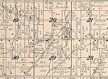
May Corner is located 5 miles (8.0 km) west of Peshtigo, at the intersection of Town Hall Road and Church Road,[2] at an elevation of 653 feet (199 m).[1] Bundy Creek, a tributary of the Peshtigo River, flows through the settlement.[2] May Corner is connected to a frontage road of U.S. Route 41 to the east, County Trunk Highway M to the south, and County Trunk Highway W to the west. The Grover town hall is located to the west, and Grover Community Church stands to the south.
Name[]
May Corner is named after the May farm, which stood on the south side of the intersection.[3] It was owned by Sam G. May (1839–1910), and later by his widow Janet "Jennie" May, née McFarlane (1853–1926).[4]
References[]
- ^ a b c U.S. Geological Survey Geographic Names Information System: May Corner, Wisconsin
- ^ a b Porterfield Quadrangle Wisconsin, 15 Minute Series (Topographic). 1963. Map, 1:62,500. Washington, DC: U. S. Geological Survey.
- ^ Standard Atlas of Marinette County Wisconsin Including a Plat Book of the Villages, Cities and Townships of the County. Chicago: Geo. A. Ogle & Co. 1912. p. 68.
- ^ "Funeral of Mrs. May". Green Bay Press Gazette. March 16, 1926. p. 27. Retrieved August 5, 2019 – via Newspapers.com.

External links[]
 Media related to May Corner, Wisconsin at Wikimedia Commons
Municipalities and communities of Marinette County, Wisconsin, United States | ||
|---|---|---|
| Cities |  | |
| Villages | ||
| Towns | ||
| CDPs | ||
| Unincorporated communities | ||
| Footnotes | ‡This populated place also has portions in an adjacent county or counties | |
| ||
This article about a location in Marinette County, Wisconsin is a stub. You can help Wikipedia by . |
- Unincorporated communities in Marinette County, Wisconsin
- Unincorporated communities in Wisconsin
- Northeast Wisconsin geography stubs