McLain, Kansas
McLain, Kansas | |
|---|---|
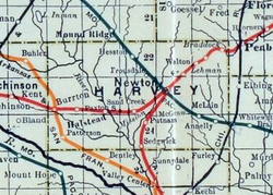 1915 Railroad Map of Harvey County | |
| Coordinates: 37°59′58″N 97°15′47″W / 37.99944°N 97.26306°WCoordinates: 37°59′58″N 97°15′47″W / 37.99944°N 97.26306°W[1] | |
| Country | United States |
| State | Kansas |
| County | Harvey |
| Elevation | 1,509 ft (460 m) |
| Time zone | UTC-6 (CST) |
| • Summer (DST) | UTC-5 (CDT) |
| ZIP code | 67114 |
| Area code | 316 |
| FIPS code | 20-43897 [1] |
| GNIS ID | 484650 [1] |


McLain is an unincorporated community in Harvey County, Kansas, United States.[1] Various maps and documents have listed the name as McLain, McLains, McLain's, and McClain. The community is located along the Missouri Pacific Railroad line between Newton and Whitewater, but the track was abandoned in 2003.[2]
History[]
McLain had a post office from 1886 until 1906.[3]
Education[]
The community is served by Newton USD 373 public school district.
References[]
- ^ a b c d e Geographic Names Information System (GNIS) details for McLain, Kansas; United States Geological Survey (USGS); October 13, 1978.
- ^ Railroad - Newton to Whitewater; abandonedrails.com
- ^ "Kansas Post Offices, 1828-1961 (archived)". Kansas Historical Society. Archived from the original on 9 October 2013. Retrieved 11 June 2014.
Further reading[]
External links[]
Municipalities and communities of Harvey County, Kansas, United States | ||
|---|---|---|
| Cities |  | |
| Unincorporated communities | ||
| Ghost town | ||
| Townships | ||
| Footnotes | ‡This populated place also has portions in an adjacent county or counties | |
| ||
Categories:
- Unincorporated communities in Harvey County, Kansas
- Unincorporated communities in Kansas