Meleti
Meleti
Melét (Lombard) | |
|---|---|
| Comune di Meleti | |
 | |
 Coat of arms | |
show Location of Meleti | |
 Meleti Location of Meleti in Italy | |
| Coordinates: 45°10′N 9°51′E / 45.167°N 9.850°E | |
| Country | Italy |
| Region | Lombardy |
| Province | Lodi (LO) |
| Government | |
| • Mayor | Mario Raffaele Rocca |
| Area | |
| • Total | 7.39 km2 (2.85 sq mi) |
| Elevation | 40 m (130 ft) |
| Population (31 October 2017)[3] | |
| • Total | 446 |
| • Density | 60/km2 (160/sq mi) |
| Demonym(s) | Meletesi |
| Time zone | UTC+1 (CET) |
| • Summer (DST) | UTC+2 (CEST) |
| Postal code | 26843 |
| Dialing code | 0377 |
| Website | Official website |


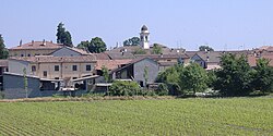
Meleti (Lodigiano: Melét; locally Mlìd) is a comune (municipality) in the Province of Lodi in the Italian region Lombardy, located about 60 kilometres (37 mi) southeast of Milan and about 30 kilometres (19 mi) southeast of Lodi.
| Wikimedia Commons has media related to Meleti. |
Meleti borders the following municipalities: Crotta d'Adda, Cornovecchio, Maccastorna, Castelnuovo Bocca d'Adda, Caselle Landi.
References[]
- ^ "Superficie di Comuni Province e Regioni italiane al 9 ottobre 2011". Istat. Retrieved 16 March 2019.
- ^ "Popolazione Residente al 1° Gennaio 2018". Istat. Retrieved 16 March 2019.
- ^ All demographics and other statistics: Italian statistical institute Istat.
| Authority control |
|
|---|
This article on a location in the Province of Lodi is a stub. You can help Wikipedia by . |
Categories:
- Cities and towns in Lombardy
- Municipalities of the Province of Lodi
- Province of Lodi geography stubs