Mellor Hall
| Mellor Hall | |
|---|---|
 | |
 Location within Greater Manchester | |
| General information | |
| Town or city | Mellor, Greater Manchester |
| Country | England |
| Coordinates | 53°23′59″N 2°01′18″W / 53.3998°N 2.0218°W |
| Completed | 1688 |

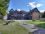
Mellor Hall is a country house in Mellor, Greater Manchester, England, 0.4 miles (0.64 km) north of the Devonshire Arms off Longhurst Lane.
The completion date of the present hall is thought to be 1688. The hall and the adjoining farmhouse, dated to 1691 and originally a smithy, has been designated by English Heritage as a Grade II* listed building.[1]
History[]
Mellor Hall was historically the seat of the Mellor family from the 15th century, and afterwards belonged to the Radcliffes.[2] In 1686, James Chetham purchased the Mellor and estates in Mellor from Susanna Radcliffe, daughter of William Radcliffe.[3] It is believed that he ordered a rebuilding of the previous manor house; the year 1688 has been mentioned as the year of completion of the hall and 1691 as the year of completion of the farmhouse, which appears to have been used originally as a smithy.[1] His great-grandson, Thomas Chetham of Highgate, Middlesex, sold the Bothams Hall estate in 1787 to local cotton magnate Samuel Oldknow, and the Mellor Hall estate to Ralph Bridge in about 1797.[2] Bridge's son was using the hall as a farmhouse as of 1819.[2]
On 20 December 1967 the house was Grade II* listed.[1] In 1978, Stockport Metropolitan Borough Council established the Mellor/Moorend Conservation Area on the border of Stockport and Derbyshire, which incorporates the hamlet of Moorend and outlying farms Longshaw Clough and Podnor, settlements at the end of Longhurst Lane, including Brook Bottom and Lower Hall and St Thomas' Church and Mellor Hall.[4] The conservation area was extended in 2007.
Architecture[]
The main hall was completed in 1688 according to Nicholas Pevsner, and the adjoining farmhouse is dated "IC 1691".[1] It is built of grey ashlar, with a graduated stone slate roof. The hall is a 2-storey building, with 7 bays on each floor, and a central door displaying a coat of arms and a steep broken swan-neck pediment.[1] Six of the ground floor windows are fitted with light ogee mullion and transom windows, with marginal glazing bars and keystones, and all of the seven first floor windows are sash windows with marginal glazing bars, cyma-moulded surrounds and keystones.[1] On the rear is a wing, with a hipped roof and quoins, mullion and transom windows; the 2 storey farmhouse extends from this wing, with 3 bays on each floor, and a central chimney stack.[1] The interior is described as having a "massive hearth with segmental keystone arch."[1]
Three nearby buildings associated with the Hall are listed at Grade II: an outbuilding that once included labourers' accommodation,[5] a former barn and shippon,[6] and a sundial.[7]

Farm building with labourers' accommodation

Former barn and shippon

Sundial


See also[]
References[]
 This article incorporates text from this source, which is in the public domain: Daniel Lyson's Magna Britannia, a concise topographical account of the several counties of Great Britain (1817)
- ^ a b c d e f g h Historic England. "Mellor Hall and Mellor Hall Farmhouse (Grade II*) (1241992)". National Heritage List for England. Retrieved 5 August 2012.
- ^ a b c Lysons 1817, p. 168.
- ^ Burke 1835, p. 12.
- ^ "Mellor/Moorend (1978, extended 2007)". Stockport Metropolitan Borough Council. Retrieved 2 February 2013.
- ^ Historic England. "Outbuilding to west of Mellor Hall and north of barn (Grade II) (1241995)". National Heritage List for England. Retrieved 26 March 2021.
- ^ Historic England. "Barn to south west of Mellor Hall (Grade II) (1241994)". National Heritage List for England. Retrieved 26 March 2021.
- ^ Historic England. "Sundial at Mellor Hall (Grade II) (1241993)". National Heritage List for England. Retrieved 26 March 2021.
- Bibliography
- Burke, John (1835). A genealogical and heraldic History of the Commoners of Great Britain and Ireland, enjoying territorial possessions or high official rank, but uninvested with heritable honours. Colburn.
- Lysons, Daniel (1817). Magna Britannia, a concise topographical account of the several counties of Great Britain, by D. and S. Lysons.

- Country houses in Greater Manchester
- Grade II* listed buildings in Greater Manchester
- Buildings and structures in the Metropolitan Borough of Stockport
- Grade II* listed houses