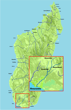
Menarandra River
| Menarandra River | |
|---|---|
 | |
| Location | |
| Country | Madagascar |
| Region | Atsimo-Andrefana, Anosy |
| Cities | Tranoroa, , |
| Physical characteristics | |
| Source | |
| • location | west of Isoanala, |
| • elevation | 600 m (2,000 ft) |
| Mouth | Indian Ocean |
• location | near , Anosy |
• coordinates | 25°16′40″S 44°29′40″E / 25.27778°S 44.49444°ECoordinates: 25°16′40″S 44°29′40″E / 25.27778°S 44.49444°E |
• elevation | 0 m (0 ft) |
| Length | 235 km (146 mi) |
| Basin size | 8,350 km2 (3,220 sq mi) |
| Basin features | |
| Tributaries | |
| • left | at Bekily, , 30 km south of Bekily |
Menarandra is a river in the regions of Anosy and Atsimo-Andrefana in southern Madagascar. It flows into the Indian Ocean near .
Its annual discharge is low, approx. 2-3 L/s/km2 at Tranoroa.
References[]
Categories:
- Atsimo-Andrefana
- Rivers of Madagascar
- Africa river stubs
- Madagascar geography stubs
