Menunkatuck Trail
| Menunkatuck Trail | |
|---|---|
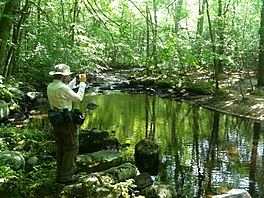 Vernal pond along the Menunkatuck Trail near the Iron Stream in the Timberlands town forest. Guilford, Connecticut. | |
| Length | 11.0 miles (17.7 km) [1] |
| Location | Connecticut |
| Designation | CFPA Blue-Blazed Trail |
| Use | hiking, cross-country skiing, snowshoeing, fishing, mountain biking (parts of the trail), other |
| Hiking details | |
| Hazards | hunters, deer ticks, poison ivy |
The Menunkatuck Trail is an 11.0-mile (17.7 km) Blue-Blazed hiking trail in Guilford, Connecticut and, currently, is almost entirely on protected land owned by the Town of Guilford, the Guilford Conservation Land Trust, the Regional Water Authority (RWA) and on Cockaponset State Forest land.
The mainline (official "Blue" "non-dot") trail is primarily a north / south linear trail with a northern trail head which terminates at the Mattabesett Trail near its southernmost point (approximately 1.3-mile (2.1 km) east of the Mattabesett Trail's intersection with (and "Bluff Head" parking lot on) Connecticut Route 77.
The current southern trail head terminates at a parking lot just outside the Town of Guilford's bulky waste site (and "Stump Dump" on Sullivan Drive just off Goose Lane (41°18′45″N 72°40′28″W / 41.3125°N 72.6745°W) although the official Menunkatuck Trail blue-blazes end just after the Menunkatuck Trail splits southward from the "White Trail" in the Nut Plains Woods (Guilford Land Conservation Trust). South of Nut Plains Road the trail to the Guilford dump is marked with red-orange plastic ribbons tied to trees. Eventually the plan is for the Menunkatuck Trail to be extended to Long Island Sound (possibly via some road walks) but the trail currently is approximately 3.0-mile (4.8 km) directly due north of Guilford Harbor (and approximately 2.0-mile (3.2 km) due north of US I-95.).
 WikiMiniAtlas
The trail walk can be extended southward from just outside the waste site on Sullivan Drive by following a red-orange plastic ribbon marked trail through the Guilford town-owned East River Preserve to a trailhead on Clapboard Hill Road north of the intersection with Meadowlands. By walking from the East River Preserve trail head on Clapboard Hill Road and then down Meadowlands a ways the trail head to a nature trail on Audubon Society property (the Guilford Salt Meadows Sanctuary) can be found and can extend the walk a bit farther.
Trail description[]

The Menunkatuck Trail is primarily used for hiking, backpacking, picnicking, and in the winter, snowshoeing.
Portions of the trail are suitable for, and are used for, cross-country skiing and geocaching. Site-specific activities enjoyed along the route include bird watching, hunting (very limited), fishing, horseback riding, bouldering and rock climbing (limited).
Trail communities[]
The official Blue-Blazed Menunkatuck Trail passes through land located within the following municipalities, from south to north:
History and folklore[]
The Blue-Blazed Menunkatuck Trail was created by the Connecticut Forest and Park Association.
This section needs expansion. You can help by . (April 2010) |
Hiking the trail[]
The mainline trail is blazed with blue rectangles. Trail descriptions are available from a number of commercial and non-commercial sources, and a complete guidebook is published by the Connecticut Forest and Park Association
Weather along the route is typical of Connecticut. Conditions on exposed ridge tops and summits may be harsher during cold or stormy weather.[2] Lightning is a hazard on exposed summits and ledges during thunderstorms. Snow is common in the winter and may necessitate the use of snowshoes. Ice can form on exposed ledges and summits, making hiking dangerous without special equipment.
Biting insects can be bothersome during warm weather. Parasitic deer ticks (which are known to carry Lyme disease) are a potential hazard. Wearing bright orange clothing during the hunting season (Fall through December) is recommended.
Conservation and maintenance of the trail corridor[]
A large portion of the Menunkatuck Trail passes through or near protected wetlands: bogs, swamps, vernal ponds and marsh lands. Wooden walkways are planned to allow easy passage over some of these which flood or become muddy often.
There are sections of the trail which are narrow forested easements between streets of substantial houses. These protected green spaces are often 'set asides' created during residential housing development.
Much of the trail is protected, owned and managed by either the Town of Guilford (often by the Conservation Committee), the Guilford Conservation Land Trust or the state (as a part of the Cockaponset State Forest).
Land owned by the Regional Water Authority and private owners is not necessarily nor specifically protected but temporary easements have been negotiated to allow the trail to pass through these properties.
See also[]
References[]
Further reading[]
Books – Connecticut hiking []
- Colson, Ann T. (2005). Connecticut Walk Book East (19 ed.). Rockfall, Connecticut: Connecticut Forest and Park Association. pp. 1–261. ISBN 0961905255.
- Colson, Ann T. (2006). Connecticut Walk Book West (19 ed.). Rockfall, Connecticut: Connecticut Forest and Park Association. pp. 1–353. ISBN 0961905263.
- Emblidge, David (1998). Hikes in southern New England: Connecticut, Massachusetts, Vermont (1 ed.). Mechanicsburg, Pennsylvania: Stackpole Books. pp. 1–304. ISBN 0-8117-2669-X.
- Keyarts, Eugene (2002). Pietrzyk, Cindi Dale (ed.). Short Nature Walks: Connecticut Guide Book (7 ed.). Guilford, Connecticut: Falcon Publishing. pp. 1–192. ISBN 0-7627-2310-6.
- Laubach, Rene; Smith, Charles W. G. (2007). AMC's Best Day Hikes in Connecticut (1 ed.). Guilford, Connecticut: Appalachian Mountain Club Books. pp. 1–320. ISBN 1-934028-10-X.
- Ostertag, Rhonda; Ostertag, George (2002). Hiking Southern New England (2 ed.). Guilford, Connecticut: Falcon Publishing. pp. 1–336. ISBN 0-7627-2246-0.
Books – Connecticut history and geography []
- De Forest, John (1853). History of the Indians of Connecticut from the earliest known period to 1850. Hartford, Connecticut: Wm. Jas. Hamersley. pp. 1–509.
- (1857). New England Gazetteer: Containing Descriptions of the States, Counties, Cities and Towns of New England (2 ed.). Boston, Massachusetts: Otis Clapp. pp. 1–704.
- Trumbull, Benjamin (1797). A Complete History of Connecticut - Civil and Ecclesiastical. Vol. Volume I (1818 printing ed.). New Haven, Connecticut: Maltby, Goldsmith & Co. and Samuel Wadsworth. pp. 1–1166.
{{cite book}}:|volume=has extra text (help) - Trumbull, Benjamin (1797). A Complete History of Connecticut - Civil and Ecclesiastical. Vol. Volume II (1818 printing ed.). New Haven, Connecticut: Maltby, Goldsmith & Co. and Samuel Wadsworth. pp. 1–1166.
{{cite book}}:|volume=has extra text (help)
Hiking trails in Connecticut | ||
|---|---|---|
| ||
- Hiking trails in Connecticut