Milo, Oregon
Milo is an unincorporated community in Douglas County, Oregon, United States, about 17 miles (27 km) east of Canyonville on the South Umpqua River.[1]
Milo post office was established in 1923; Cora E. Buker was the first postmaster.[2] It was named for Milo, Maine, the hometown of Amos O. Buker, who was the husband of Cora.[2] Originally the post office at this locale was named "Perdue", named after John Perdue, Sr., who was also its first postmaster.[2] It was originally at the confluence of the South Umpqua River and Elk Creek—which today is the location of Tiller—and the office was first called "Elk Creek".[2] Elk Creek post office was founded in 1877.[2] Perdue took over as postmaster of the Elk Creek post office on June 11, 1884 and on August 22, the name was changed to Perdue.[2] At the same time the office was moved to the current location of Milo.[2] The office was closed in 1920 when no one could be found to replace then-postmaster Amos Buker, who was fired after he had acted against postal regulations by working as a United States Census enumerator.[2] Today Milo has a Days Creek mailing address.[3][4]
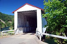
Oregon's only steel bridge capped with a covered bridge structure crosses the South Umpqua River in Milo.[5] The bridge was built in 1962 and covered by the request of local residents who missed the earlier wooden bridge at this location.[6] The Milo Academy Bridge is the only access to the Milo Adventist Academy, a private Seventh-day Adventist boarding school.[6] The bridge is on the National Register of Historic Places.[7]
References[]
- ^ "Milo". Geographic Names Information System. United States Geological Survey. November 28, 1980. Retrieved 2010-01-10.
- ^ a b c d e f g h McArthur, Lewis A.; McArthur, Lewis L. (2003) [1928]. Oregon Geographic Names (7th ed.). Portland, Oregon: Oregon Historical Society Press. pp. 323–324, 647, 754. ISBN 978-0875952772.
- ^ "Milo Adventist Academy: About: Location". Retrieved 2010-01-10.
- ^ Note: ZIP Code 97429.
- ^ Friedman, Ralph (1990). In Search of Western Oregon (2nd ed.). Caldwell, Idaho: The Caxton Printers, Ltd. p. 552. ISBN 0-87004-332-3.
- ^ a b Cockrell, Bill; Nick Cockrell. "South Umpqua River (Milo Academy) Covered Bridge" (PDF). Roofs Over Rivers. Oregon State Library. Archived from the original (PDF) on 2013-12-31. Retrieved 2010-01-10.
- ^ "Oregon National Register List" (PDF). Oregon Parks and Recreation Department. October 19, 2009. Retrieved 2010-01-10.
External links[]
- Historic images of Milo from Salem Public Library
- Image of Milo Academy Bridge from the Oregon State Archives
Municipalities and communities of Douglas County, Oregon, United States | ||
|---|---|---|
| Cities |  | |
| CDPs | ||
| Unincorporated communities | ||
| Indian reservations | ||
| Footnotes | ‡This populated place also has portions in an adjacent county or counties | |
| ||
Coordinates: 42°55′50″N 123°02′59″W / 42.930676°N 123.049779°W

- Unincorporated communities in Douglas County, Oregon
- 1923 establishments in Oregon
- Unincorporated communities in Oregon