Minocqua, Wisconsin
Minocqua, Wisconsin
Minwaakwaa | |
|---|---|
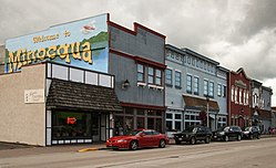 Downtown Minocqua | |
| Nickname(s): The Island City | |
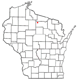 Location of Minocqua, Wisconsin | |
| Coordinates: 45°52′14.3″N 89°42′33.0″W / 45.870639°N 89.709167°WCoordinates: 45°52′14.3″N 89°42′33.0″W / 45.870639°N 89.709167°W | |
| Country | |
| State | |
| County | Oneida |
| Government | |
| • Chairman[2] | Mark Hartzheim[1] |
| • Town Clerk[1] | Roben Haggart[1] |
| • Town Treasurer[1] | Kim Strasburg[1] |
| • Town Secretary[1] | Karla Wotruba[1] |
| Area | |
| • Total | 168.1 sq mi (435.3 km2) |
| • Land | 150.8 sq mi (390.6 km2) |
| • Water | 17.3 sq mi (44.8 km2) |
| Elevation | 1,598 ft (487 m) |
| Population (2000) | |
| • Total | 4,859 |
| • Density | 32.2/sq mi (12.4/km2) |
| Time zone | UTC-6 (Central (CST)) |
| • Summer (DST) | UTC-5 (CDT) |
| Area code(s) | 715 & 534 |
| FIPS code | 55-53225[4] |
| GNIS feature ID | 1583727[3] |

Minocqua (Ojibwe: Minwaakwaa)[5] is a town in northwestern Oneida County, Wisconsin, United States. The population was 4,388 as of 2017.[6] The census-designated place of Minocqua and the unincorporated community of Rantz are both located in the town. Minocqua is commonly referred to as "The Island City."[7]
History[]
Minocqua was officially organized in the year 1889. Although there are varying explanations regarding the meaning of the word "Minocqua", most credit its origin to the Island's first inhabitants, the Ojibwe.[8] The town Minocqua is named after, "Ninocqua", the Ojibwe name that is defined as "noon-day-rest".[2][9]
In the late 1800s, Minocqua was a logging town. Minocqua Clawson was the first white child born in the town. Clawson Hill was a famous landmark in town, and it is now the current location of the Pointe Resort & Hotel at the south end of the Highway 51 bridge.
The construction of railroads was a critical component of Minocqua's early growth. The Milwaukee Road originally came to the area to provide access to timber. Later, railroads catered to sportsmen and tourists, transforming Minocqua into the vacation getaway it remains to this day. The two railroad trestles that brought trains to the Island are still intact and serve as the trailhead for the Bearskin State Trail that provides hiking and biking in summer, and snowmobiling in winter.
Much of the town's business district was destroyed by a major fire in 1912. Many of the buildings on the main street today were designed and built after the fire. Although the last several decades have brought a higher percentage of visitor-oriented retail stores, the downtown still retains a U.S. post office, banks, restaurants, and a barbershop. The Island, Minocqua's city center, contains the Campanile Center for the Arts, the Minocqua Police Department, Minocqua Fire Department, and the Minocqua Community Center, which houses the town offices and public library.
Landmarks on the Island include Torpy Park, the Belle-Isle building, the Minocqua Community Center, Bosacki's Boathouse (now The Boathouse), T Murtaugh's Pub, and the Thirsty Whale. Town offices and the Minocqua Public Library are located in the Minocqua Community Center. Bosacki's Boat House burned to the ground in 1972. Although state regulations prohibited the structure being rebuilt over water, a public outcry convinced the DNR to allow it to be rebuilt where it had originally stood.
Geography[]
According to the United States Census Bureau, the town has a total area of 168.1 square miles (435.4 km2), of which, 150.8 square miles (390.6 km2) of it is land and 17.3 square miles (44.8 km2) of it is water. The total area is 10.29% water.
Termed the "Island City," a portion of the town is situated on what was an actual island, which is accessible by bridge on Highway 51 and "the fill" to the north. Much of Minocqua has sandy soil, although areas of the far northwest and the northeast are clay. The majority of the soil is highly acidic and many areas are covered by forests.
The highest point in Minocqua is Squirrel Hill, located near Winter Park (1735 ft).[10] The highest structure in Minocqua is the Lakeland Sanitary District water tower, a steel tank on Hwy 51 North put in place in the 1960s during the winter.
The community of Bo-di-Lac (short for "Booth-Diamond-Lac du Flambeau) is located in the western portion of the town bordered by Squirrel Lake, Diamond Lake, Booth Lake, and the town of Lac du Flambeau.
Demographics[]
As of the census[4] of 2010, there are 4,385 people living in the town occupying 2,079 households. There are a total of 4,835 housing units in town of which 2,493 are seasonal in nature.
The racial makeup of the town is 96.1% White, 0.2% African American, 1.7% Native American, 0.8% Asian, 0.1% from other races, and 1.2% from two or more races. 0.8% of the population are Hispanic or Latino of any race.
26.4% of the town's population is age 65 or older while 16.3% is below the age of 18. The median age is 51.6 years.
The average household size is 2.11 persons.
Transportation[]
The Lakeland Airport (KARV) is located 3 miles northwest of the central business district of Minocqua.
The Rhinelander-Oneida County Airport (KRHI) located 25 miles to the southeast serves Minocqua, Oneida county and surrounding communities with both scheduled commercial jet service and general aviation services.
Government[]
The town board, consisting of a town chairman and four supervisors, is responsible for governing the citizens of Minocqua.[2] There have been 30 town chairmen in the history of Minocqua. The list of early town chairmen include A.O. Dorwin, Lincoln Abraham, Jacob Huber, Thomas Bolger, William Schlecht, and Dr. Torpy.[11]
Minocqua is entirely located in Wisconsin's 34th Assembly, 12th Senate, and 7th Congressional District, and is represented by State Representative Rob Swearingen and Congressman Tom Tiffany. The 12th Senate district is current open following the election of Senator Tom Tiffany to the US Congress on May 12, 2020. [2]
Education[]
Minocqua has a public elementary school, Minocqua-Hazelhurst-Lake Tomahawk Elementary School, a private Lutheran elementary/middle school, Trinity Lutheran School,[12] and a high school, Lakeland Union High School.
Tourism[]
Tourism plays a substantial role in the economy of Minocqua. As a forested lake community, there are many outdoor summer activities, such as fishing, camping, waterskiing, boating, hiking, bike riding, berry collecting, and swimming.
A business strip runs through the downtown ("The Island"), with tourist attractions and shopping. Minocqua's nightlife includes bars hosting live music in the summer. A Fourth of July parade is presented annually. Events include dancing, live music, fireworks, and a Min-Aqua Bat waterski and boat show.
During the fall, rifle and bow hunting draw many visitors, as does the annual downtown merchants' Beef-a-Rama held the last Saturday in September. Winter activities include snowmobile festivals, Nordic (cross country) skiing, ice fishing, downhill skiing in nearby hills, snow tubing, sleigh rides, and snowmobiling. Minocqua is home to Minocqua Winter Park, a cross-country skiing venue, as well as a sledding hill and ice-skating pond.
Minocqua is home to one of the world's oldest amateur water ski teams, the Min-Aqua Bats. The Min-Aqua bats have been performing at the Aqua Bowl for 70 summers now, as a nonprofit organization and will open up the 71st season in June 2020. [13]
Arts activities include the Campanile Center for the Arts which operates year-round, offering an array of high quality artists to captivate, intrigue and inspire audiences. The Campanile also provides music, theater, and visual art instruction.
Museums[]
The Minocqua Museum is located in Minocqua.[14] Its exhibits portray Minocqua’s early days.
The U.S. flag that was lowered by the last U.S. soldiers to depart from the Vietnam War is on exhibit at the American Legion Post in Minocqua.[15]

Images[]

Minocqua sign
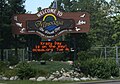
Welcome sign

Bridge over Lake Minocqua in the Minocqua CDP

Downtown

Downtown

A view of Blue Lake from Camp Agawak

This is a view of Camp Agawak from the Waterfront


See also[]
References[]
- ^ a b c d e f g "Departments | Town of Minocqua".
- ^ a b c d "Minocqua, WI | History of Minocqua, Woodruff, and Arbor Vitae".
- ^ a b U.S. Geological Survey Geographic Names Information System: Minocqua
- ^ a b "U.S. Census website". United States Census Bureau. Retrieved 2008-01-31.
- ^ "Translate Ojibwe", English-Ojibwe Dictionary, "Minocqua". [1]
- ^ Bureau, US Census. "Data". www.census.gov. Retrieved 2019-05-28.
- ^ "Town of Minocqua | the Island City".
- ^ Minocqua History. Town of Minocqua.
- ^ http://www.minocqua.com/channel/Ojibwa-Indians/2556
- ^ Wisconsin Blue Book
- ^ http://www.townofminocqua.org
- ^ "Trinity Lutheran School & Preschool".
- ^ "History". 10 June 2016. Retrieved February 1, 2018.
- ^ Minocqua Museum opens for summer season June 7
- ^ American Legion Post 89 home to significant national artifact
External links[]
| Wikimedia Commons has media related to Minocqua, Wisconsin. |
- Official website
- Minocqua Public Library
- Minocqua Area Chamber of Commerce
- Minocqua Tourism, Events and Business Directory
Municipalities and communities of Oneida County, Wisconsin, United States | ||
|---|---|---|
| City |  | |
| Towns | ||
| CDPs | ||
| Other communities | ||
| Ghost town | ||
| Footnotes | ‡This populated place also has portions in an adjacent county or counties | |
| ||
- Towns in Oneida County, Wisconsin
- Towns in Wisconsin