Misilyah
Misilyah | |
|---|---|
Municipality type D (Village council) | |
| Arabic transcription(s) | |
| • Arabic | مسلية |
 | |
 Misilyah Location of Misilyah within the West Bank | |
| Coordinates: 32°23′12″N 35°17′17″E / 32.38667°N 35.28806°ECoordinates: 32°23′12″N 35°17′17″E / 32.38667°N 35.28806°E | |
| Palestine grid | 177/199 |
| State | State of Palestine |
| Governorate | Jenin |
| Government | |
| • Type | Village council |
| Population (2006) | |
| • Total | 2,252 |
| Name meaning | 'an example', In Phænician: 'an image', in old Arabic it means: 'traces of a dwelling which are becoming effaced'[1] |


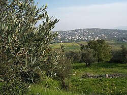
Misilyah (Arabic: مسلية), sometimes spelled Mithilîyeh and Misilîyeh, is a Palestinian village in the northern West Bank, located 14 kilometers south of the city of Jenin. According to the Palestinian Central Bureau of Statistics, the village had a population of 2,252 inhabitants in mid-year 2006.[2] The main agricultural crops cultivated in Misilya are olives, grapes, figs, and vegetables. Roman and Islamic ruins have been found in the village.
Geography[]
Misilyah is situated in a small plain in the foothills of Jabal Faḳu'ah, or Mount Gilboa.[3] The plain, Marj al-Gharaḳ, also spelled Merj el-Ghǔrǔk, which lacks any natural drainage, was described at the beginning of the 20th century as transforming into a large swamp during the rainy season, only to dry up in summer, when the resulting field was cultivated with grain.[4]
History[]
C. R. Conder suggested in the 1880s that Misilyah was ancient Bethulia,[5][6] but Zertal, 2004, found no archeological evidence supporting this.[7]
Pottery sherds from the late Roman, Byzantine, early Muslim and Medieval eras have been found here.[7]
Ottoman era[]
In 1838, Edward Robinson noted the village when he travelled in the region, as bordering the extremely fertile Marj Sanur.[8] He listed it as part of the District of Haritheh, north of Nablus.[9]
In 1870, Victor Guérin noted it, "sitting on the northern slopes of a hill planted with superb olive trees; at the bottom there is a fertile and well-cultivated plain."[10]
In 1882, the PEF's Survey of Western Palestine described Meselieh: "A small village, with a detached portion to the north, and placed on a slope, with a hill to the south, and surrounded by good olive-groves, with an open valley called Wady el Melek (' the King's Valley') on the north. The water-supply is from wells, some of which have an ancient appearance. They are mainly supplied with rain-water."[11]
British Mandate era[]
In the 1922 census of Palestine conducted by the British Mandate authorities, Meselayyeh had a population 190 Muslims,[12] increasing in the 1931 census to 222 Muslim, in a total of 49 houses.[13]
In the 1945 statistics the population was 330 Muslims,[14] with a total of 9,038 dunams of land, according to an official land and population survey.[15] Of this, 2,683 dunams were used for plantations and irrigable land, 2,592 dunams were for cereals,[16] while a total of 23 dunams were built-up, urban land.[17]
Jordanian era[]
In the wake of the 1948 Arab–Israeli War, and after the 1949 Armistice Agreements, Misilyah came under Jordanian rule.
In 1961, the population of Misilya was 606.[18]
Post-1967[]
After the Six-Day War in 1967, Misilyah has been under Israeli occupation.
On 17 January 2016 a 21 year old resident of Masliya was shot dead by Israeli soldiers.[19][20]
References[]
- ^ Palmer, 1881, pp. 112 188
- ^ Projected Mid -Year Population for Jenin Governorate by Locality 2004- 2006 Archived 2008-09-20 at the Wayback Machine Palestinian Central Bureau of Statistics
- ^ Marcus Jastrow; Frants Buhl (1901–1906). "Bethulia (Bαιτουλοόα, Bαιτουλία, Bετυλοόα, Bαιτυλοόα; Vulgate, Bethulia)". The Jewish Encyclopedia. Funk & Wagnalls. Retrieved 28 June 2018.
- ^ Joseph Jacobs; Immanuel Benzinger; Judah David Eisenstein (1901–1906). "Palestine". The Jewish Encyclopedia. Funk & Wagnalls. Retrieved 28 June 2018.
- ^ Conder, 1881, pp.194–195
- ^ Conder and Kitchener, 1883, SWP III, pp. 436-437
- ^ Jump up to: a b Zertal, 2004, pp. 228-229
- ^ Robinson and Smith, 1841, vol 3, p. 153
- ^ Robinson and Smith, 1841, vol 3, 2 appendix, p. 130
- ^ Guérin, 1874, p. 344
- ^ Conder and Kitchener, 1882, SWP II, pp. 156-157
- ^ Barron, 1923, Table V, Sub-district of Jenin, p. 29
- ^ Mills, 1932, p. 69
- ^ Government of Palestine, Department of Statistics, 1945, p. 16 Archived 2018-09-05 at the Wayback Machine
- ^ Government of Palestine, Department of Statistics. Village Statistics, April, 1945. Quoted in Hadawi, 1970, p. 54
- ^ Government of Palestine, Department of Statistics. Village Statistics, April, 1945. Quoted in Hadawi, 1970, p. 99
- ^ Government of Palestine, Department of Statistics. Village Statistics, April, 1945. Quoted in Hadawi, 1970, p. 149
- ^ Government of Jordan, Department of Statistics, 1964, p. 25
- ^ Palestinian shot dead near Nablus after alleged attempted attack Ma'an 17/1/2016
- ^ Palestinian Shot After Attempting to Stab Israelis in the West Bank Ha'aretz 17/1/2016
Bibliography[]
- Barron, J.B., ed. (1923). Palestine: Report and General Abstracts of the Census of 1922. Government of Palestine.
- Conder, C.R. (1881). "Meselieh". Quarterly Statement - Palestine Exploration Fund. 13: 194–195.
- Conder, C.R.; Kitchener, H.H. (1882). The Survey of Western Palestine: Memoirs of the Topography, Orography, Hydrography, and Archaeology. 2. London: Committee of the Palestine Exploration Fund.
- Conder, C.R.; Kitchener, H.H. (1883). The Survey of Western Palestine: Memoirs of the Topography, Orography, Hydrography, and Archaeology. 3. London: Committee of the Palestine Exploration Fund.
- Government of Jordan, Department of Statistics (1964). First Census of Population and Housing. Volume I: Final Tables; General Characteristics of the Population (PDF).
- Government of Palestine, Department of Statistics (1945). Village Statistics, April, 1945.
- Guérin, V. (1874). Description Géographique Historique et Archéologique de la Palestine (in French). 2: Samarie, pt. 1. Paris: L'Imprimerie Nationale.
- Hadawi, S. (1970). Village Statistics of 1945: A Classification of Land and Area ownership in Palestine. Palestine Liberation Organization Research Center.
- Mills, E., ed. (1932). Census of Palestine 1931. Population of Villages, Towns and Administrative Areas. Jerusalem: Government of Palestine.
- Palmer, E.H. (1881). The Survey of Western Palestine: Arabic and English Name Lists Collected During the Survey by Lieutenants Conder and Kitchener, R. E. Transliterated and Explained by E.H. Palmer. Committee of the Palestine Exploration Fund.
- Robinson, E.; Smith, E. (1841). Biblical Researches in Palestine, Mount Sinai and Arabia Petraea: A Journal of Travels in the year 1838. 3. Boston: Crocker & Brewster.
- Zertal, A. (2004). The Manasseh Hill Country Survey. 1. Boston: BRILL. ISBN 9004137564.
External links[]
- Welcome to Misilya, Palestine remembered
- Survey of Western Palestine, Map 11: IAA, Wikimedia commons
| hide Jenin Governorate | ||
|---|---|---|
| Cities |  | |
| Municipalities |
| |
| Villages |
| |
| Refugee camps | ||
- Villages in the West Bank
- Jenin Governorate
- Municipalities of the State of Palestine