Montecalvo Irpino
Montecalvo Irpino | |
|---|---|
| Comune di Montecalvo Irpino | |
 | |
show Location of Montecalvo Irpino | |
 Montecalvo Irpino Location of Montecalvo Irpino in Italy | |
| Coordinates: 41°11′48″N 15°2′3″E / 41.19667°N 15.03417°ECoordinates: 41°11′48″N 15°2′3″E / 41.19667°N 15.03417°E | |
| Country | Italy |
| Region | Campania |
| Province | Avellino (AV) |
| Frazioni | , |
| Government | |
| • Mayor | Mirko Iorillo |
| Area | |
| • Total | 53.53 km2 (20.67 sq mi) |
| Elevation | 623 m (2,044 ft) |
| Population (1 January 2017)[3] | |
| • Total | 3,663 |
| • Density | 68/km2 (180/sq mi) |
| Demonym(s) | Montecalvesi |
| Time zone | UTC+1 (CET) |
| • Summer (DST) | UTC+2 (CEST) |
| Postal code | 83037 |
| Dialing code | 0825 |
| Patron saint | St. Felix |
| Saint day | 30 August |
| Website | Official website |


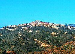
Montecalvo Irpino is a town and comune in the province of Avellino, Campania, southern Italy.
Located upon a hill oversighting Ufita Valley, the town is known for its bread (), which is granted PAT quality mark, and DOP olive oil.
In the countryside there are the ruins of fortified village, devastated by 1656 plague and since abandoned, and , the widest mudpots field in Southern Italy.
References[]
- ^ "Superficie di Comuni Province e Regioni italiane al 9 ottobre 2011". Istat. Retrieved 16 March 2019.
- ^ "Popolazione Residente al 1° Gennaio 2018". Istat. Retrieved 16 March 2019.
- ^ All demographics and other statistics from the Italian statistical institute (Istat); Dati - Popolazione residente all'1/5/2009
External links[]
| Wikimedia Commons has media related to Montecalvo Irpino. |

| Authority control |
|
|---|
This Campanian location article is a stub. You can help Wikipedia by . |
Categories:
- Cities and towns in Campania
- Municipalities of the Province of Avellino
- Hilltowns in Campania
- Campanian geography stubs