Monteleone Sabino
Monteleone Sabino | |
|---|---|
| Comune di Monteleone Sabino | |
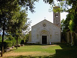 Santa Vittoria Shrine. | |
 Coat of arms | |
show Location of Monteleone Sabino | |
 Monteleone Sabino Location of Monteleone Sabino in Italy | |
| Coordinates: 42°13′59″N 12°51′30″E / 42.23306°N 12.85833°ECoordinates: 42°13′59″N 12°51′30″E / 42.23306°N 12.85833°E | |
| Country | Italy |
| Region | Latium |
| Province | Rieti (RI) |
| Frazioni | Ginestra Sabina |
| Government | |
| • Mayor | Angelo Paolo Marcari |
| Area | |
| • Total | 18.8 km2 (7.3 sq mi) |
| Elevation | 496 m (1,627 ft) |
| Population (30 November 2017)[3] | |
| • Total | 1,231 |
| • Density | 65/km2 (170/sq mi) |
| Demonym(s) | Monteleonesi |
| Time zone | UTC+1 (CET) |
| • Summer (DST) | UTC+2 (CEST) |
| Postal code | 02033 |
| Dialing code | 0765 |
| Website | Official website |


Monteleone Sabino is a comune (municipality) in the Province of Rieti in the Latium region of Italy, located about 45 kilometres (28 mi) northeast of Rome and about 20 kilometres (12 mi) south of Rieti.
Main sights[]
- Trebula Mutusca: ruins of the ancient Sabine town
- Santa Vittoria: 12th-century Romanesque shrine or sanctuary church, which left side was rebuilt during the 15th century.
Twin towns[]
 Santa Vittoria in Matenano, Italy
References[]
- ^ "Superficie di Comuni Province e Regioni italiane al 9 ottobre 2011". Istat. Retrieved 16 March 2019.
- ^ "Popolazione Residente al 1° Gennaio 2018". Istat. Retrieved 16 March 2019.
- ^ All demographics and other statistics: Italian statistical institute Istat.
External links[]
| Wikimedia Commons has media related to Monteleone Sabino. |
| Authority control |
|---|
This Lazio location article is a stub. You can help Wikipedia by . |
Categories:
- Cities and towns in Lazio
- Municipalities of the Province of Rieti
- Lazio geography stubs