Montséret
show This article may be expanded with text translated from the corresponding article in French. (December 2008) Click [show] for important translation instructions. |
Montséret | |
|---|---|
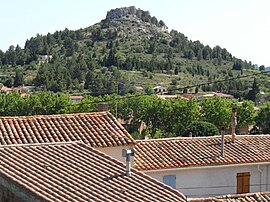 Roquelongue seen from Montséret | |
 Coat of arms | |
show Location of Montséret | |
 Montséret | |
| Coordinates: 43°06′13″N 2°48′42″E / 43.1036°N 2.8117°ECoordinates: 43°06′13″N 2°48′42″E / 43.1036°N 2.8117°E | |
| Country | France |
| Region | Occitanie |
| Department | Aude |
| Arrondissement | Narbonne |
| Canton | Les Corbières |
| Intercommunality | Région Lézignanaise, Corbières et Minervois |
| Government | |
| • Mayor (2008–2014) | Jean-Luc Jalabert |
| Area 1 | 11.31 km2 (4.37 sq mi) |
| Population (Jan. 2018)[1] | 608 |
| • Density | 54/km2 (140/sq mi) |
| Time zone | UTC+01:00 (CET) |
| • Summer (DST) | UTC+02:00 (CEST) |
| INSEE/Postal code | 11256 /11200 |
| Elevation | 55–240 m (180–787 ft) (avg. 97 m or 318 ft) |
| 1 French Land Register data, which excludes lakes, ponds, glaciers > 1 km2 (0.386 sq mi or 247 acres) and river estuaries. | |


Montséret is a commune in the Aude department in southern France. Montséret is a small wine-producing village in the wine district of Corbières. The village's annual festival is held in early- to mid-July and includes a community dinner.
Population[]
| Year | Pop. | ±% |
|---|---|---|
| 1962 | 351 | — |
| 1968 | 360 | +2.6% |
| 1975 | 308 | −14.4% |
| 1982 | 306 | −0.6% |
| 1990 | 347 | +13.4% |
| 1999 | 410 | +18.2% |
| 2008 | 483 | +17.8% |
See also[]
- Corbières AOC
- Communes of the Aude department
References[]
- ^ "Populations légales 2018". INSEE. 28 December 2020.
| Wikimedia Commons has media related to Montséret. |
| show Communes of the Aude department |
|---|
This Aude geographical article is a stub. You can help Wikipedia by . |
Categories:
- Communes of Aude
- Aude geography stubs