Mooroolbark railway station
Mooroolbark | |||||||||||||||||||||||||||||||||||||||||||||||||||||||||||||||||||||||||||||||||||||||||||||||||||||||||||||||||||||||||||||||||||||
|---|---|---|---|---|---|---|---|---|---|---|---|---|---|---|---|---|---|---|---|---|---|---|---|---|---|---|---|---|---|---|---|---|---|---|---|---|---|---|---|---|---|---|---|---|---|---|---|---|---|---|---|---|---|---|---|---|---|---|---|---|---|---|---|---|---|---|---|---|---|---|---|---|---|---|---|---|---|---|---|---|---|---|---|---|---|---|---|---|---|---|---|---|---|---|---|---|---|---|---|---|---|---|---|---|---|---|---|---|---|---|---|---|---|---|---|---|---|---|---|---|---|---|---|---|---|---|---|---|---|---|---|---|---|
| PTV commuter rail station | |||||||||||||||||||||||||||||||||||||||||||||||||||||||||||||||||||||||||||||||||||||||||||||||||||||||||||||||||||||||||||||||||||||
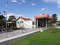
 Westbound view from Platform 1 in November 2021 | |||||||||||||||||||||||||||||||||||||||||||||||||||||||||||||||||||||||||||||||||||||||||||||||||||||||||||||||||||||||||||||||||||||
| Location | Brice Avenue, Mooroolbark, Victoria 3138 Shire of Yarra Ranges Australia | ||||||||||||||||||||||||||||||||||||||||||||||||||||||||||||||||||||||||||||||||||||||||||||||||||||||||||||||||||||||||||||||||||||
| Coordinates | 37°47′05″S 145°18′45″E / 37.7847°S 145.3125°ECoordinates: 37°47′05″S 145°18′45″E / 37.7847°S 145.3125°E | ||||||||||||||||||||||||||||||||||||||||||||||||||||||||||||||||||||||||||||||||||||||||||||||||||||||||||||||||||||||||||||||||||||
| Owned by | VicTrack | ||||||||||||||||||||||||||||||||||||||||||||||||||||||||||||||||||||||||||||||||||||||||||||||||||||||||||||||||||||||||||||||||||||
| Operated by | Metro Trains | ||||||||||||||||||||||||||||||||||||||||||||||||||||||||||||||||||||||||||||||||||||||||||||||||||||||||||||||||||||||||||||||||||||
| Line(s) | Lilydale | ||||||||||||||||||||||||||||||||||||||||||||||||||||||||||||||||||||||||||||||||||||||||||||||||||||||||||||||||||||||||||||||||||||
| Distance | 34.38 kilometres from Southern Cross | ||||||||||||||||||||||||||||||||||||||||||||||||||||||||||||||||||||||||||||||||||||||||||||||||||||||||||||||||||||||||||||||||||||
| Platforms | 2 (1 island, elevated) | ||||||||||||||||||||||||||||||||||||||||||||||||||||||||||||||||||||||||||||||||||||||||||||||||||||||||||||||||||||||||||||||||||||
| Tracks | 2 | ||||||||||||||||||||||||||||||||||||||||||||||||||||||||||||||||||||||||||||||||||||||||||||||||||||||||||||||||||||||||||||||||||||
| Connections | Bus | ||||||||||||||||||||||||||||||||||||||||||||||||||||||||||||||||||||||||||||||||||||||||||||||||||||||||||||||||||||||||||||||||||||
| Construction | |||||||||||||||||||||||||||||||||||||||||||||||||||||||||||||||||||||||||||||||||||||||||||||||||||||||||||||||||||||||||||||||||||||
| Structure type | Elevated | ||||||||||||||||||||||||||||||||||||||||||||||||||||||||||||||||||||||||||||||||||||||||||||||||||||||||||||||||||||||||||||||||||||
| Parking | 364 | ||||||||||||||||||||||||||||||||||||||||||||||||||||||||||||||||||||||||||||||||||||||||||||||||||||||||||||||||||||||||||||||||||||
| Bicycle facilities | 8 | ||||||||||||||||||||||||||||||||||||||||||||||||||||||||||||||||||||||||||||||||||||||||||||||||||||||||||||||||||||||||||||||||||||
| Disabled access | Yes | ||||||||||||||||||||||||||||||||||||||||||||||||||||||||||||||||||||||||||||||||||||||||||||||||||||||||||||||||||||||||||||||||||||
| Other information | |||||||||||||||||||||||||||||||||||||||||||||||||||||||||||||||||||||||||||||||||||||||||||||||||||||||||||||||||||||||||||||||||||||
| Status | Operational, Premium Station | ||||||||||||||||||||||||||||||||||||||||||||||||||||||||||||||||||||||||||||||||||||||||||||||||||||||||||||||||||||||||||||||||||||
| Station code | MLK | ||||||||||||||||||||||||||||||||||||||||||||||||||||||||||||||||||||||||||||||||||||||||||||||||||||||||||||||||||||||||||||||||||||
| Fare zone | Myki Zone 2 | ||||||||||||||||||||||||||||||||||||||||||||||||||||||||||||||||||||||||||||||||||||||||||||||||||||||||||||||||||||||||||||||||||||
| Website | Public Transport Victoria | ||||||||||||||||||||||||||||||||||||||||||||||||||||||||||||||||||||||||||||||||||||||||||||||||||||||||||||||||||||||||||||||||||||
| History | |||||||||||||||||||||||||||||||||||||||||||||||||||||||||||||||||||||||||||||||||||||||||||||||||||||||||||||||||||||||||||||||||||||
| Opened | 10 October 1887 | ||||||||||||||||||||||||||||||||||||||||||||||||||||||||||||||||||||||||||||||||||||||||||||||||||||||||||||||||||||||||||||||||||||
| Rebuilt | 19 November 2021 (Level Crossing Removal Project) | ||||||||||||||||||||||||||||||||||||||||||||||||||||||||||||||||||||||||||||||||||||||||||||||||||||||||||||||||||||||||||||||||||||
| Electrified | 1500 V DC overhead (1925) | ||||||||||||||||||||||||||||||||||||||||||||||||||||||||||||||||||||||||||||||||||||||||||||||||||||||||||||||||||||||||||||||||||||
| Services | |||||||||||||||||||||||||||||||||||||||||||||||||||||||||||||||||||||||||||||||||||||||||||||||||||||||||||||||||||||||||||||||||||||
| |||||||||||||||||||||||||||||||||||||||||||||||||||||||||||||||||||||||||||||||||||||||||||||||||||||||||||||||||||||||||||||||||||||
| |||||||||||||||||||||||||||||||||||||||||||||||||||||||||||||||||||||||||||||||||||||||||||||||||||||||||||||||||||||||||||||||||||||

Mooroolbark railway station is located on the Lilydale line in Victoria, Australia. It serves the eastern Melbourne suburb of Mooroolbark, and it opened on 10 October 1887.[1]
A crossover is located at the Up end of the station, which allows services to terminate here. The station also marks the end of double track on the Lilydale line.
In 1981, a number of sidings at the station were abolished.[1]
Flashing light signals were provided at the former Manchester Road level crossing, which was located at the Up end of the station, in 1949, with boom barriers provided later on in 1983.[1]
The former ground level Platform 2 was provided in 1985, along with new track that allowed Down trains to enter the platform.[2][3][4] This was in conjunction with the provision of Automatic Signalling between Mooroolbark and Lilydale.[4]
In October 2013, three new small shelters were built at the ends of both former ground level platforms. Platform 1 had shelters at each end, while Platform 2 had one at the Down (Lilydale) end. Both platforms also had raised platforms installed, reducing the need for a wheelchair ramp to be used.
In 2015, the Level Crossing Removal Authority announced the removal of the Manchester Road level crossing.[5] Work commenced in 2020 to have the level crossing removed by 2022, with a rail over road method preferred for its removal. The rebuilt station reopened to passengers on 19 November 2021.[6]
Platforms and services[]
Mooroolbark has one island platform with two faces. It is serviced by Metro Trains' Lilydale line services.[7]
Platforms 1:
- Lilydale line all stations and limited stops services to Flinders Street, Ringwood and Lilydale
Platforms 2:
- Lilydale line services to Lilydale
Transport links[]
Ventura Bus Lines operates four routes via Mooroolbark station, under contract to Public Transport Victoria:
- 675 : to Chirnside Park Shopping Centre[8]
- 680 : to Lilydale station[9]
- FlexiRide Croydon [10]
- FlexiRide Mooroolbark [10]
Gallery[]
Former ground level Platform 1 entrance in March 2015, following a 2014 upgrade
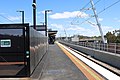
Westbound view from Platform 2 in November 2021


References[]
- ^ a b c Mooroolbark Vicsig
- ^ "Ringwood East to Lilydale". Victorian Railways Signalling Diagram No 14’82. www.signaldiagramsandphotos.com. Retrieved 13 May 2016.
- ^ "Ringwood East to Lilydale". The Met Signalling Diagram No 57’85. www.signaldiagramsandphotos.com. Retrieved 13 May 2016.
- ^ a b Works. Australian Railway Historical Society (Victorian Division). November 1985. p. 344. ISSN 0310-7477.
- ^ "Projects in planning". levelcrossings.vic.gov.au. Archived from the original on 13 January 2016. Retrieved 19 January 2016.
- ^ "Countdown continues: level crossings 48 and 49 gone for good". Level Crossing Removal Project. Retrieved 20 November 2021.
- ^ "Lilydale Line". Public Transport Victoria.
- ^ "675 Chirnside Park - Mooroolbark via Manchester Road". Public Transport Victoria.
- ^ "680 Lilydale - Mooroolbark via Lilydale East Estate & Lakeview Estate". Public Transport Victoria.
- ^ a b On-demand bus service FlexiRide expands to Chirnside Park, Lilydale, Mooroolbark and Croydon Public Transport Victoria
External links[]
- Melway map at street-directory.com.au
- Premium Melbourne railway stations
- Railway stations in Melbourne
- Railway stations in Australia opened in 1887