Motagua River
| Motagua River | |
|---|---|
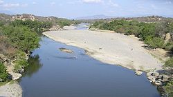 The Motagua River during the dry season | |
 The Motagua River, flowing from the highlands in western Guatemala to the coast at the Guatemala–Honduras border | |
| Location | |
| Countries | Guatemala and Honduras |
| Physical characteristics | |
| Source | Quiché Department |
| • coordinates | 14°56′57″N 91°00′32″W / 14.94917°N 91.00889°W |
| • elevation | 1,800 m (5,900 ft) |
| 2nd source | Baja Verapaz Department |
| Mouth | Gulf of Honduras in the Atlantic Ocean |
• location | Puerto Barrios |
• coordinates | 15°43′29″N 88°13′18″W / 15.72472°N 88.22167°WCoordinates: 15°43′29″N 88°13′18″W / 15.72472°N 88.22167°W |
• elevation | 0 m (0 ft) |
| Length | 486.55 km (302.33 mi)[1] |
| Basin size | 12,670 km2 (4,890 sq mi)[1] |
| Discharge | |
| • average | 208.7 m3/s (7,370 cu ft/s)[1] |

The Motagua River (Spanish pronunciation: [moˈtaɣwa]) is a 486-kilometre-long (302 mi) river in Guatemala.[1] It rises in the western highlands of Guatemala where it is also called Río Grande, and runs in an easterly direction to the Gulf of Honduras.[2] The final few kilometres of the river form part of the Guatemala–Honduras border. The Motagua River basin covers an area of 12,670 square kilometres (4,890 sq mi) and is the largest in Guatemala.
Overview[]
The river runs in a valley that has the only known source of jadeitite (jade) in Mesoamerica, and was an important commerce route during the Pre-Columbian era. The important Maya site of Quirigua is near the river's north bank, as are several smaller sites with jade quarries and workshops.
The Motagua river valley also marks the Motagua Fault, the tectonic boundary between the North American and the Caribbean Plates. The Motagua fault has been the source of several major earthquakes in Guatemala. Much like Lake Amatitlán, the river is highly polluted with untreated sewage, industrial waste, tons of sediment (garbage) and blackwater from Guatemala City.
Tributaries[]
Left[]
Río Cocoyá, Río Cotón, Río Suchicul, Río Morazán, Río Comajá, Río Lato, Río Huijo, Río La Palmilla, Río Teculutan, Río Pasabien, Río Hondo, Río Jones, RíoLos Achiotes, Río Mayuelas, Río El Lobo, Quebrada Agua Fría, Quebrada La Vegega, Río Las Conchas
Right[]
Río Chipaca, Rio Agua Escondida, Rio Quisaya, Rio Pixcayá, Río Cotzibal, Río Las Vacas, Río Grande, Río Ovejas, Río El Tambor, Río San Vicente, Río Grande o Zapaca, Río Carí, Río Las Naranjas, Río Biafra, Río El Islote, Río Jubuco, Río Lagarto, Río Tepemechín, Río Juyamá, Río Bobos, Río Animas, Río Chiquito, Río Nuevo o Cacao
References[]
- ^ Jump up to: a b c d INSIVUMEH. "Principales ríos de Guatemala".
- ^ "Tapping a Rubber Tree, Motagua Valley, Guatemala". World Digital Library. 1890–1925. Retrieved 2013-05-30.
External links[]
| Wikimedia Commons has media related to Motagua River. |
| Authority control |
|
|---|
- Rivers of Guatemala
- Rivers of Honduras
- Geography of Mesoamerica
- International rivers of North America
- Guatemala–Honduras border
- Border rivers