Mount Ōmuro (Shizuoka)
show This article may be expanded with text translated from the corresponding article in Japanese. (February 2021) Click [show] for important translation instructions. |
| Mount Ōmuro | |
|---|---|
| 大室山 | |
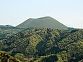
 Mount Ōmuro seen from the west. | |
| Highest point | |
| Elevation | 580 m (1,900 ft)[1] |
| Coordinates | 34°54′11″N 139°5′40″E / 34.90306°N 139.09444°ECoordinates: 34°54′11″N 139°5′40″E / 34.90306°N 139.09444°E |
| Geography | |
| Location | Itō, Shizuoka Prefecture, Japan |
| Geology | |
| Mountain type | Cinder cone[2] |
| Last eruption | about 4000 years ago[2] |

Mount Ōmuro (大室山, Ōmuroyama) is a 580 m (1,900 ft)-high cinder cone volcano in the Izu-Tobu volcano field of Itō, Shizuoka, Japan. At the independent peak, the yearly mountain burning that been performed for more than 700 years is carried out in the early spring,[3] so it is often covered with annual plants and is a symbol of Itō. The mountain is designated as a national natural monument and part of Fuji-Hakone-Izu National Park.
Gallery[]
From the northwest.
Symbolic pyroclastic cone of the Izu-Tobu volcano field.

Looking up from the north foot.


External links[]
- The story of the land of Izu pages 82-87 in Japanese - Masato Koyama , Shizuoka University
- Mount Ōmuro Geosite - Izu Peninsula Geopark
- Mount Ōmuro Geosite - Japanese site differs from above.
References[]
- ^ "Mount Omuro, Japan". Peakbagger.com. Retrieved 2021-02-21.
- ^ Jump up to: a b 出典 : 大室山ジオサイト - 伊豆半島ジオパーク、2016年1月閲覧
- ^ 「山に炎 伊豆に春」『読売新聞』朝刊2020年2月25日(社会面)2020年2月29日閲覧
Categories:
- Mountains of Shizuoka Prefecture
- Fuji-Hakone-Izu National Park
- Volcanoes of Shizuoka Prefecture