Izu-Tobu
This article includes a list of general references, but it remains largely unverified because it lacks sufficient corresponding inline citations. (February 2012) |
| Izu-Tobu | |
|---|---|
| Izu-Tobu volcano field | |
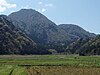
 Mount Ōmuro, a symbolic pyroclastic cone of the Izu-Tobu volcano field | |
| Highest point | |
| Elevation | 1,406 m (4,613 ft) |
| Coordinates | 34°53′59″N 139°05′52″E / 34.89972°N 139.09778°ECoordinates: 34°53′59″N 139°05′52″E / 34.89972°N 139.09778°E |
| Naming | |
| Native name | 伊豆東部火山群 |
| Geography | |
 Izu-Tobu Izu Peninsula, Shizuoka Prefecture, Japan | |
| Geology | |
| Mountain type | Pyroclastic cones |
| Last eruption | July 1989 |


Izu-Tobu (伊豆東部火山群, Izu Tōbu Kazangun) is a large, dominantly basaltic range of volcanoes on the east side of the Izu Peninsula which lies on the Pacific coast of the island of Honshu in Japan. The field covers a total area of 400 km2. The only recorded activity was a submarine phreatic eruption, between the city of Ito and Hatsushima island, that lasted for just 10 minutes in 1989. Ito, home to 74,000 people, is known for its hot springs.
Morphology[]
The field covers the east side of the Izu Peninsula. It consists of several small stratovolcanoes (mostly Pleistocene in age) and overlapping pyroclastic cones, which covers 400 km2 in area. There are 70 young monogenetic volcanoes on land. Kawagodaira maar, which is about 3,000 years old, produced a large Holocene eruption that sent pyroclastic flows over a wide area.
Eruptions[]

1989 eruption[]
The only recorded eruption was an event on 13 July 1989. Two earthquakes, on 30 June and 9 July took, place on the Izu-Tobu Volcano. On 13 July, a seismometer recorded seismicity, a research vessel, the RV Takuyo reported hearing an explosion sound from the sea floor followed by a 30-second vibration at 18:33 pm. At 18:40 pm the crew reported that the sea domed up 500 m from the vessel, then a grey-black plume rose from the area, five more domes were reported in the next 5 minutes which caused the ship to vibrate. After that seismicity declined.
This marks the only known eruptive activity at Izu-Tobu. The next day a survey using an unmanned vessel discovered a new cone 100 metres underwater. The cone was around 450 Metres wide with a summit crater 200 m in diameter. The height of the cone above the sea floor was only 10 m in height.
The University of Tokyo monitors Izu-Tobu 24 hours a day.
Distinct cones[]
| Image | Name | Location | Type[1][2] | Height | Eruption[1][2] | Coordinates | Comments |
|---|---|---|---|---|---|---|---|

|
Mount Ōmuro (大室山) |
Itō | Cinder cone | 580 m | 4 ka | 34°54′11″N 139°05′40″E / 34.9031°N 139.0945°E | Lava flow formed the Jōgasaki coast. |
 (Right)
|
Mount Komuro (小室山) |
Itō | Cinder cone | 321 m | 15 ka | 34°56′21″N 139°07′52″E / 34.9391°N 139.131°E | |
 |
Mount Io (伊雄山) |
Itō | Cinder cone | 459 m | 2.7 ka | 34°52′18″N 139°04′46″E / 34.8717°N 139.0795°E | |

|
Mount Tōgasa (遠笠山) |
Izu & Higashizu |
Cinder cone | 1,197 m | 14 ka - 15 ka | 34°52′43″N 139°01′57″E / 34.8786°N 139.0325°E | Oldest volcano in Izu-Tobu volcano field |
|
Kawagodaira (皮子平) |
Izu | Volcanic crater | approx. 1,090 m | 3.2 ka | 34°51′36″N 138°58′55″E / 34.860°N 138.982°E | |

|
Mount Maruno (丸野山) |
Izu | Cinder cone | 697 m | 107 ka | 34°54′40″N 139°01′26″E / 34.911°N 139.024°E | |

|
Mount Sukumo (巣雲山) |
Izu | Cinder cone | 581 m | 132 ka | 35°00′18″N 139°02′13″E / 35.005°N 139.037°E | |

|
Mount Hachikubo (鉢窪山) |
Izu | Cinder cone | 674 m | 17 ka | 34°51′43″N 138°55′44″E / 34.862°N 138.929°E | Lava flow from Mount Hachikubo formed Jōren Falls. |
|
Mount Maru (丸山) |
Izu | Cinder cone | 938 m | 17 ka | 34°51′18″N 138°56′20″E / 34.855°N 138.939°E | |

|
Mount Takatsuka (高塚山) |
Izunokuni | Cinder cone | 369 m | 132 ka | 35°00′59″N 138°58′48″E / 35.0165°N 138.98°E | Cinder cone was halved by quarrying.[citation needed] |

|
Mount Hachino (鉢ノ山) |
Kawazu | Cinder cone | 619 m | 36 ka | 34°47′35″N 138°58′16″E / 34.793°N 138.971°E | |
 (Left)
|
Mount Yahazu (矢筈山) |
Itō | Lava dome | 816 m | 2.7 ka | 34°53′42″N 139°03′25″E / 34.895°N 139.057°E | |
(Right)
|
Mount Anano (孔ノ山) |
Itō | Lava dome | 660 m | 2.7 ka | 34°54′00″N 139°03′11″E / 34.9°N 139.053°E | |
|
Mount Iwano (岩ノ山) |
Izu | Lava dome | 602 m | 2.7 ka | 34°54′47″N 139°02′20″E / 34.913°N 139.039°E | |

|
Ippeki lake (一碧湖) |
Itō | Maar | Surface elevation 185 m[3] |
103.5 ka | 34°55′48″N 139°06′18″E / 34.93°N 139.105°E | |

|
Jōgasaki coast (城ヶ崎海岸) |
Itō | Lava flow | -
|
4 ka |
34°53′24″N 139°08′17″E / 34.89°N 139.138°E | This coast was mostly formed by lava flow from Mount Ōmuro. |
 |
Teishi knoll (手石海丘) |
Sagami Sea (off Itō) | Volcanic crater | 81 m below sea level | 13 July 1989 | 34°59′06″N 139°07′08″E / 34.985°N 139.118889°E | Youngest volcano in Izu-Tobu volcano field. Eruption video by Japan Coast Guard |
See Also[]
- List of volcanoes in Japan
- List of mountains in Japan
References[]
- "Izu-Tobu". Global Volcanism Program. Smithsonian Institution. Retrieved 2021-06-24.
- Volcanolive.com
External links[]
| Wikimedia Commons has media related to Izu-tobu Volcano Group. |
- Izu-Tobu Volcanoes – Japan Meteorological Agency (in Japanese)
- "Izu-Tobu Volcanoes : National catalogue of the active volcanoes in Japan" (PDF). – Japan Meteorological Agency
- Izu Tobu Volcano Group – Geological Survey of Japan
- Eruptive history of the Higashi Izu monogenetic volcano field – Shizuoka University
- Active volcanoes
- Fuji-Hakone-Izu National Park
- Volcanoes of Shizuoka Prefecture
- Mountain ranges of Shizuoka Prefecture
- Monogenetic volcanic fields