Mount Audubon
| Mount Audubon | |
|---|---|
 Mt. Audubon, Front Range, Colorado | |
| Highest point | |
| Elevation | 13,229 ft (4,032 m)[1][2] |
| Prominence | 843 ft (257 m)[2] |
| Isolation | 3.36 mi (5.41 km)[2] |
| Coordinates | 40°05′56″N 105°36′59″W / 40.0988749°N 105.6163912°WCoordinates: 40°05′56″N 105°36′59″W / 40.0988749°N 105.6163912°W[3] |
| Naming | |
| Etymology | John James Audubon |
| Geography | |
 Mount Audubon Colorado | |
| Location | Boulder County, Colorado, U.S.[3] |
| Parent range | Front Range, Indian Peaks[2] |
| Topo map | USGS 7.5' topographic map Ward, Colorado[3] |
| Climbing | |
| Easiest route | hike |

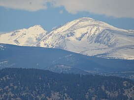
Mount Audubon is a high mountain summit of the Indian Peaks in the northern Front Range of the Rocky Mountains of North America. The 13,229-foot (4,032 m) thirteener is located in the Indian Peaks Wilderness of Roosevelt National Forest, 5.6 miles (9.0 km) west-northwest (bearing 287°) of the Town of Ward in Boulder County, Colorado, United States.[1][2][3] The mountain was named in honor of John James Audubon.
See also[]
- List of Colorado mountain ranges
- List of Colorado mountain summits
- List of Colorado fourteeners
- List of Colorado 4000 meter prominent summits
- List of the most prominent summits of Colorado
- List of Colorado county high points
References[]
- ^ Jump up to: a b The elevation of Mount Audubon includes an adjustment of +1.681 m (+5.52 ft) from NGVD 29 to NAVD 88.
- ^ Jump up to: a b c d e "Mount Audubon, Colorado". Peakbagger.com. Retrieved November 5, 2014.
- ^ Jump up to: a b c d "Mount Audubon". Geographic Names Information System. United States Geological Survey. Retrieved November 5, 2014.
External links[]
Mount Audubonat Wikipedia's sister projects
 Definitions from Wiktionary
 Media from Wikimedia Commons
 News from Wikinews
 Quotations from Wikiquote
 Texts from Wikisource
 Textbooks from Wikibooks
 Resources from Wikiversity
| show |
|---|
| show |
|---|

| show |
|---|
This Colorado state location article is a stub. You can help Wikipedia by . |
Categories:
- Mountains of Colorado
- Mountains of Boulder County, Colorado
- Roosevelt National Forest
- North American 4000 m summits
- Colorado geography stubs