Mount Izari
| Mount Izari | |
|---|---|
| 漁岳 | |
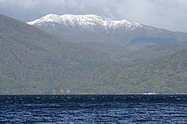 Lake Shikotsu and Mount Izari | |
| Highest point | |
| Elevation | 1,317.7 m (4,323 ft) |
| Coordinates | 42°49′16″N 141°14′08″E / 42.82111°N 141.23556°ECoordinates: 42°49′16″N 141°14′08″E / 42.82111°N 141.23556°E |
| Naming | |
| English translation | fishing mountain |
| Language of name | Japanese |
| Pronunciation | [Izaridake] |
| Geography | |
| Location | Hokkaido, Japan |

This article needs additional citations for verification. (March 2021) |
Mount Izari (漁岳, Izaridake) is a volcano with an altitude of 1,318 m at the junction of Eniwa, Chitose and Sapporo, Ishikari Subprefecture, Hokkaido. It has been selected as one of the 100 famous mountains in Hokkaido. A second-class triangulation station "Izaridake" is set up on the mountaintop.[1]
Etymology[]
Mount Izari is derived from the whose water source is this mountain. The etymology of "Izari" is the Ainu word for "Ichankoppesan," which means "river spawning salmon and trout."[2] There is a mountain of the same name "Ichankoppesan" nearby.
References[]
- ^ 国土地理院 基準点成果等閲覧サービス
- ^ 『山渓カラー名鑑 日本の山1000』山と渓谷社、1992年
Categories:
- Mountains of Hokkaido
- One-thousanders of Asia
- Volcanoes of Hokkaido