Mount Kaguyak
| Mount Kaguyak | |
|---|---|
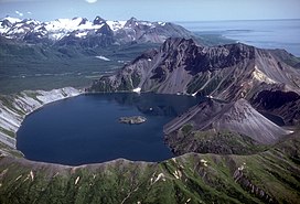 Lake filled caldera of Kaguyak, August 1982. | |
| Highest point | |
| Elevation | 2,956 ft (901 m)[1] |
| Listing | List of volcanoes in the United States |
| Coordinates | 58°36′28.8″N 154°1′40.8″W / 58.608000°N 154.028000°W |
| Geography | |
 Mount Kaguyak | |
| Parent range | Aleutian Range |
| Geology | |
| Mountain type | Stratovolcano |
| Volcanic arc/belt | Aleutian Arc |
| Last eruption | 3850 BCE[2] |

Mount Kaguyak is a stratovolcano located in the northeastern part of the Katmai National Park and Preserve in the U.S. state of Alaska. The 2.5 km wide caldera is filled by a more than 180 m deep crater lake. The surface of the crater lake lies about 550 m below the rim of the caldera. Postcaldera lava domes form a prominent peninsula in the center of the lake. The volcano is 901 metres (2,956 ft) high and is topographically prominent because it rises from lowland areas near sea level in the south of the . Based on radiocarbon dating the caldera-forming eruption occurred about 5800 years before present.[3] During this eruption at least 120 km2 (46 sq mi) were covered in a dacitic ignimbrite.[3]

References[]
- ^ "Kaguyak Crater". Alaska Volcano Observatory. Retrieved 2017-12-24.
- ^ "Kaguyak". Global Volcanism Program. Smithsonian Institution. Retrieved 2017-12-24.
- ^ a b Fierstein, Judi. "Explosive eruptive record in the Katmai region, Alaska Peninsula: an overview". Bulletin of Volcanology. 69 (5): 469–509. doi:10.1007/s00445-006-0097-y.
Sources[]
- "Volcanoes of the Alaska Peninsula and Aleutian Islands-Selected Photographs". Digital Data Series DDS-40. U.S. Geological Survey. Retrieved 18 November 2018.
This article about a location in the Kodiak Island Borough, Alaska is a stub. You can help Wikipedia by . |
- Stratovolcanoes of the United States
- Volcanoes of Kodiak Island Borough, Alaska
- Mountains of Kodiak Island Borough, Alaska
- Mountains of Alaska
- Volcanoes of Alaska
- VEI-5 volcanoes
- Calderas of Alaska
- Volcanic crater lakes
- Aleutian Range
- Kodiak Island Borough, Alaska geography stubs