Mount Khajeh
| Mount Khajeh | |
|---|---|
| Mount Khwajeh | |
 Mount Khajeh | |
| Highest point | |
| Elevation | 609 m (1,998 ft) |
| Coordinates | 30°56′21″N 61°14′44″E / 30.9391°N 61.2455°ECoordinates: 30°56′21″N 61°14′44″E / 30.9391°N 61.2455°E |
| Geography | |
 Mount Khajeh Sistan and Baluchestan, Iran | |
| Geology | |
| Mountain type | Hill |
| Type of rock | Black basalt |


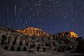
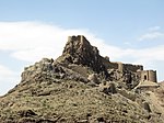
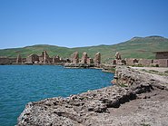
Mount Khwaja or Mount Khwajeh (locally: Kuh-e Khvājeh) is a flat-topped black basalt hill rising up as an island in the middle of Lake Hamun, in the Iranian province of Sistan and Baluchestan.[1]
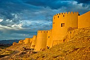
The trapezoid-shaped basalt lava outcropping, located 30 km southwest of the town of Zabol, rises to 609 meters above sea level and has a diameter ranging from 2.0 to 2.5 kilometres. It is the only natural height in the Sistan area, and is named after an Islamic pilgrimage site on the hill: the tomb and shrine of Khwaja Ali Mahdi, a descendant of Ali ibn Abi Talib.[2]
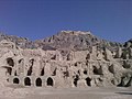
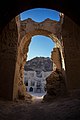
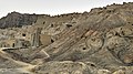
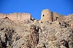
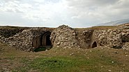
Mount Khwaja is also considered an important archaeological site. On the southern promontory of the eastern slope, the ruins of a citadel complex - known as the Ghagha-Shahr - with its remains of a fire temple date to pre-Islamic Iran. According to Zoroastrian legend, Lake Hamun is "the keeper of Zoroaster's seed." In Zoroastrian eschatology, when the final renovation of the world is near, maidens will enter the lake and then give birth to the saoshyans, the saviours of humankind.[3]
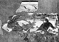
The fire temple is on a terrace behind high walls and is protected by two forts, whose remains are respectively known as Kok-e Zal and Chehel Dokhtaran. Collectively, the ruins are called Qal'a-e Kafaran "Fort of Infidels" or Qal'a-e Sam "Fort of Sam," the grandfather of the mythical Rostam (one of the fortresses here is named "Rostams castle"). Both names reflect pre-Islamic heritage. The walls of the temple were once extravagantly decorated with murals, some of which are now on display in museums in Tehran, Berlin, New Delhi and New York.
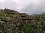
The citadel complex was first investigated by Marc Aurel Stein in 1915–1916. The site was later excavated by Ernst Herzfeld, and was again investigated in part by Giorgio Gullini in a short expedition of 1960. Initially, Herzfeld tentatively dated the palace complex to the 1st century CE, that is, to the Arsacid period (248 BCE-224 CE). Herzfeld later revised his estimate to a later date and today the Sassanid period (224-651 CE) is usually considered to be more likely. Three bas-reliefs on the outer walls that depict riders and horses are attributed to this later period. Beyond the citadel at the top of the plateau are several other unrelated buildings, of uncertain function and probably dating to the Islamic period.[4]
Murals[]

Mount Khajeh mural

Mount Khajeh mural
Drawing of a Mount Khajeh painting, Ghahga-Shahr

Kuh-i Khwaja Sasanian wall painting of a woman with mouth cover, 7th century CE

Kuh-i Khwaja Sasanian wall painting, 7th century CE


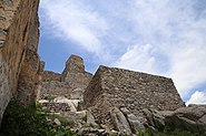
Ruins[]


See also[]
- Sistan Basin
- Helmand River
References[]
- ^ "Mount Khajeh: A Flat-Topped Black Basalt Hill". Big News Network.com. Retrieved 2020-08-09.
- ^ Editorial Staff (2020-05-04). "Mount Khajeh, the Ancient Castle Town in Iran". Destination Iran Tours. Retrieved 2020-08-09.
- ^ "Mount Khajeh is a flat-topped black basalt hill rising up as an island in the middle of Lake Hamun, in the Iranian province of Sistan and Baluchestan. Khajeh Mountain is located 30 km south of Zabul and is amazingly beautiful in the holy water of Hamoon. The mountain is made up of basaltic black stones. A series of monuments in the mountains include a huge building, a fire temple, two brick castles, remains of the old road, various fences and a number of rocky graves. - Picture of Sistan and Baluchistan Province, Iran - Tripadvisor". www.tripadvisor.com. Retrieved 2020-08-09.
- ^ www.sirang.com, Sirang Rasaneh. "Mount Khajeh 2020 Tourist Attraction in Zabol, travel to iran, Visit Iran". itto.org | Iran Tourism & Touring. Retrieved 2020-08-09.
- Keall, Edward J. "Architecture: Parthian Period". Encyclopædia Iranica. ISSN 2330-4804. Retrieved April 8, 2018.
- Ramazan-nia, Nersi (February 1997). "The treasures of Lake Hamun: An Interview with Soroor Ghanimati". The Iranian. Berkeley, California: Abadan Publishing Co. Retrieved April 8, 2018.
External links[]
| Wikimedia Commons has media related to Mount Khajeh. |
- Ernst Herzfeld Papers, Series 5: Drawings and Maps, Records of Kuh-e Khwaja Collections Search Center, S.I.R.I.S., Smithsonian Institution, Washington, D.C.
| Capital |
|  | |||||||||||||||||||||||||||||||||||||||||
|---|---|---|---|---|---|---|---|---|---|---|---|---|---|---|---|---|---|---|---|---|---|---|---|---|---|---|---|---|---|---|---|---|---|---|---|---|---|---|---|---|---|---|---|
| Counties and cities |
| ||||||||||||||||||||||||||||||||||||||||||
| Sights |
| ||||||||||||||||||||||||||||||||||||||||||
| Populated places | |||||||||||||||||||||||||||||||||||||||||||
| East Azerbaijan |
| 
 |
|---|---|---|
| West Azerbaijan |
| |
| Isfahan |
| |
| Ardabil |
| |
| Alborz |
| |
| Bushehr |
| |
| Kohgiluyeh and Boyer-Ahmad | ||
| Golestan | ||
| Gilan |
| |
| Tehran |
| |
| Chaharmahal and Bakhtiari |
| |
| North Khorasan |
| |
| Razavi Khorasan |
| |
| South Khorasan |
| |
| Khuzestan |
| |
| Kurdistan | ||
| Semnan |
| |
| Sistan and Baluchestan |
| |
| Fars |
| |
| Qazvin |
| |
| Qom |
| |
| Kerman |
| |
| Kermanshah |
| |
| Mazandaran |
| |
| Markazi |
| |
| Lorestan | ||
| Ilam |
| |
| Hormozgan |
| |
| Hamadan |
| |
| Yazd |
| |
| Zanjan | ||
Also See: Castles in Iran | ||


| Azerbaijan |
| 
 | |||||||||||||||||||||||||||||||||||||||||||||||||||||
|---|---|---|---|---|---|---|---|---|---|---|---|---|---|---|---|---|---|---|---|---|---|---|---|---|---|---|---|---|---|---|---|---|---|---|---|---|---|---|---|---|---|---|---|---|---|---|---|---|---|---|---|---|---|---|---|
| Georgia |
| ||||||||||||||||||||||||||||||||||||||||||||||||||||||
| Iraq |
| ||||||||||||||||||||||||||||||||||||||||||||||||||||||
| Iran |
| ||||||||||||||||||||||||||||||||||||||||||||||||||||||
| Oman |
| ||||||||||||||||||||||||||||||||||||||||||||||||||||||
| Russia |
| ||||||||||||||||||||||||||||||||||||||||||||||||||||||
| Saudi Arabia |
| ||||||||||||||||||||||||||||||||||||||||||||||||||||||
Also See: Sasanian castles | |||||||||||||||||||||||||||||||||||||||||||||||||||||||


- Mountains of Iran
- Archaeological sites in Iran
- Architecture of Iran
- Castles in Iran
- Landforms of Sistan and Baluchestan Province
- Sistan
- Former populated places in Iran
- Buildings and structures in Sistan and Baluchestan Province
- Tourist attractions in Sistan and Baluchestan Province
- National works of Iran
- Sasanian castles