Mount Myōjin
| Mount Myōjin | |
|---|---|
| 明神岳 | |
 Mount Myōjin from east | |
| Highest point | |
| Elevation | 1,432 m (4,698 ft) |
| Listing | List of mountains and hills of Japan by height |
| Coordinates | 34°21′39″N 136°5′42″E / 34.36083°N 136.09500°E |
| Naming | |
| Language of name | Japanese |
| Pronunciation | [mjoːdʑindake] |
| Geography | |
| Location | Matsusaka, Mie and Kawakami, Nara, Japan |
| Parent range | |

Mount Myōjin (明神岳, Myōjin-dake) is a 1,432 m (4,698 ft) mountain, on the border of Matsusaka, Mie and Kawakami, Nara, Japan. This mountain is one of .
Routes[]
There are two major routes to the top of Mount Myōjin. The route from Maakodani Tozanguchi takes about three hours. The other route is via from of . It takes about three and half hours.
Access[]
- Ōmata Bus Stop of Nara Kōtsu
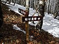
Gallery[]

Mount Myōjin from Mount Hinokizuka Okumine (03/2009)

Mount Myōjin from Mount Azami (03/2009)

The top of Mount Myōjin (03/2009)

Myojindaira on the way to Mount Myōjin (03/2009)
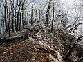
On the way to Mount Myōjin (03/2009)
A view at Mount Myōjin (03/2009)

The entrance of a climbing route to Mount Myōjin (03/2009)
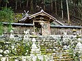
Sasano Shrine at Ōmata (03/2009)


References[]
Categories:
- Mountains of Nara Prefecture
- Mountains of Mie Prefecture