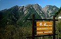
Mount Nokogiri (Akaishi)
| Mount Nokogiri | |
|---|---|
| 鋸岳 | |
 View of Mount Nokogiri from Mount Kaikoma (August 2008) | |
| Highest point | |
| Elevation | 2,685 m (8,809 ft) |
| Listing | List of mountains and hills of Japan by height |
| Coordinates | 35°46′45″N 138°12′36″E / 35.77917°N 138.21000°ECoordinates: 35°46′45″N 138°12′36″E / 35.77917°N 138.21000°E |
| Naming | |
| English translation | (wood)saw mountain |
| Language of name | Japanese |
| Geography | |
| Location | Japan |
| Parent range | Akaishi Mountains |
| Topo map | Geographical Survey Institute 25000:1 甲斐駒ヶ岳 50000:1 甲府 |

Mount Nokogiri (鋸岳, Nokogiri-dake) is a mountain located in the Akaishi Mountains on the border between, Yamanashi and Nagano Prefectures in Japan.
Outline[]
This area is in Minami Alps National Park that was established on June 1, 1964.[1] This mountain is also one of the "200 Famous Japanese Mountains". There is no general mountain climbing trail. Therefore, it is difficult to climb it. There is the shelter Mountain hut ("6th Stone-Hut") between this mountain and Mount Kaikoma. The original hut was rebuilt in 2006.
Geography[]
Nearby Mountains[]
It is on the main ridge line in the northern edge of the Akaishi Mountains.
| Image | Mountain | Japanese | Height | Distance from the Top |
Note |
|---|---|---|---|---|---|

|
Mt. Nokogiri | 鋸岳 | 2,685 m (8,809 ft) | 0 km (0.0 mi) | 200 Famous |

|
Mt. Kaikoma | 甲斐駒ヶ岳 | 2,967 m (9,734 ft) | 3.4 km (2 mi) | 100 Famous |

|
Mt. Senjō | 仙丈ヶ岳 | 3,033 m (9,951 ft) | 7.0 km (4.3 mi) | 100 Famous |
River of source[]
Mount Nokogiri is the source of the Fuji River. The Rivers of the source flow to the Pacific Ocean.
- Fuji River
- Todai River (Tributary of Tenryū River)
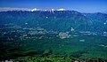
Gallery[]
Mount Nokogiri from Utajuku
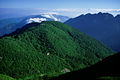
Mount Nokogiri and Uma-no-Se from Mount Ko-Senjō

Mount Nokogiri from Mount Ko-Senjō
Mount Kita, Mount Kaikoma and Mount Nokogiri from Yatsugatake


See also[]
References[]
- ^ Minami Alps National Park Archived 2011-03-22 at the Wayback Machine(HP of the Ministry of the Environment)
External links[]
| Wikimedia Commons has media related to Mount Nokogiri (Akaishi Mountains). |
This article about a location in Yamanashi Prefecture is a stub. You can help Wikipedia by . |
This Nagano Prefecture location article is a stub. You can help Wikipedia by . |
- Akaishi Mountains
- Japan Alps
- Mountains of Yamanashi Prefecture
- Mountains of Nagano Prefecture
- Minami Alps National Park
- Yamanashi geography stubs
- Nagano geography stubs