Muav Limestone
| Muav Limestone Stratigraphic range: Middle Cambrian[1][2] | |
|---|---|
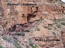 representative sequence of Redwall Limestone, Temple Butte Formation, and Muav Limestone, in Grand Canyon | |
| Type | Geological formation |
| Unit of | Tonto Group |
| Underlies | Redwall Limestone (Mississippian). Locally underlies Temple Butte Formation (Devonian) that fills narrow paleovalleys cut into the unconformity separating the Redwall Limestone from Muav Limestone. |
| Overlies | Bright Angel Shale |
| Thickness | 650 feet (200 m), at maximum |
| Lithology | |
| Primary | limestone and dolomite |
| Other | calcareous mudstone |
| Location | |
| Region | Northern Arizona (Grand Canyon), central Arizona, southeast California, southern Nevada, and southeast Utah |
| Country | United States of America |
| Type section | |
| Named for | Muav Canyon, north side of Colorado River[3] |
| Named by | Noble (1914)[3] |
The Cambrian Muav Limestone is the upper geologic unit of the 3-member Tonto Group. It is about 650 feet (198 m) thick at its maximum.[4] It is a resistant cliff-forming unit. The Muav consists of dark to light-gray, brown, and orange red limestone with dolomite and calcareous mudstone.[5] The Muav is overlain in some areas by the Devonian Temple Butte Formation, but the major unit above, are the vertical cliffs of Mississippian Redwall Limestone. The Muav is located in the lower elevations of the Grand Canyon, Arizona.[6]
The Muav is in part younger than, and in-part grades into, the Bright Angel Shale, which is less erosion resistant and is categorized as a slope-forming unit. The Muav is about 350 feet thick in the east and reaches about 600 feet thick in the western part of its exposure area in the Grand Canyon.[5] The two units lie above the erosion-resistant cliff-forming Tapeats Sandstone.
In the eastern canyon, the Tapeats Sandstone creates the extremely horizontal . In west Grand Canyon, the north-south Toroweap Fault is the west perimeter of the Tonto Platform, and west Grand Canyon is dominated by the erosion resistant unit of the Esplanade Sandstone. The Tonto Trail is a mostly horizontal trail on the south side of Granite Gorge, on the Tonto Platform.

(expandable photo)
The Tonto Group units were deposited on an ancient erosion surface (angular unconformity) on the Vishnu Basement Rocks. The Vishnu sequence has a dip of about 45 degrees. As this long-timeframe unconformity represents about 1,000 million years (1.0 billion years) of non–deposition, tectonic activity and erosion, on the Vishnu Basement Rocks, is called the Great Unconformity.
Beyond the Grand Canyon area the Muav occurs in southern Utah, southern Nevada and southern California. In the California occurrence it is known as the Muav Marble.[5]
Geologic sequence[]
The units of the Tonto Group:
- (1)-Temple Butte Formation, Devonian – (409–363 Ma), channel deposits upon Muav Limestone
- Tonto Group (~544–505 Ma)
- 3-Muav Limestone
- 2-Bright Angel Shale
- 1-Tapeats Sandstone
See also[]
References[]
| Wikimedia Commons has media related to Muav Limestone. |
| Wikimedia Commons has media related to Muav Limestone cliffs. |
| Wikimedia Commons has media related to Tonto Group. |
- ^ Rose, E. (2006) "Nonmarine aspects of the Cambrian Tonto Group of the Grand Canyon, USA, and broader implications". Palaeoworld. 15:223–241.
- ^ Rose, E (2011) Modification of the nomenclature and a revised deposition model for the Cambrian Tonto Group of the Grand Canyon, Arizona. in JS Hollingsworth, FA Sundberg, and JR Foster, eds., pp. 77–98, Cambrian Stratigraphy and Paleontology of Northern Arizona and Southern Nevada: Museum of Northern Arizona Bulletin 67, 321 p.
- ^ Jump up to: a b Noble, LF (1914). "The Shinumo quadrangle, Grand Canyon district, Arizona" (PDF). U.S. Geological Survey Bulletin. 549. doi:10.3133/B549. ISSN 8755-531X. Wikidata Q57659039.
- ^ Chronic, H (1983) Roadside Geology of Arizona. The Mountaineers Books, Seattle, Washington. (softcover, ISBN 978-0-87842-147-3) p. 179.
- ^ Jump up to: a b c Anonymous (2006d) Muav Limestone Archived 2015-11-22 at the Wayback Machine, Stratigraphy of the Parks of the Colorado Plateau Archived 2010-12-24 at the Wayback Machine. U.S. Geological Survey, Reston, Virginia.
- ^ Hampton, HM (1998) Geologic Map of the Grand Canyon in the Vicinity of the South Rim Visitor Center. in Kamilli, RJ, and SM Richard, eds., Geologic Highway Map of Arizona, Arizona Geological Society and Arizona Geological Survey, 1 sheet, scale 1:62,500.
Popular Publications[]
- Blakey, and Ranney, 2008. Ancient Landscapes of the Colorado Plateau, Ron Blakey, Wayne Ranney, c 2008, Grand Canyon Association (publisher), 176 pages, with Appendix, Glossary, Index. Contains approximately 75 shaded topographic maps, for geology, etc., with 54 (23 pairs, (46)) for Colorado Plateau specifically; others are global, or North American.
- Chronic, Halka. Roadside Geology of Arizona, 1983, 23rd printing, Mountain Press Publishing Co. 322 pages. pp. 229–32. (softcover, ISBN 978-0-87842-147-3)
- Arizona Geological Society, Arizona Geological Survey, c. 1998 (etc.) Geologic Highway Map of Arizona. Contains geologic map, Arizona Shaded Relief Map, Geologic Cross Sections, Shaded Relief Map of Arizona, Geologic Map of the Grand Canyon in the Vicinity of the South Rim Visitor Center, etc.
External links[]
- Abbot, W, (2001) Revisiting the Grand Canyon – Through the Eyes of Seismic Sequence Stratigraphy. Search and Discovery Article # 40018, America Association of Petroleum Geologists, Tulsa, Oklahoma.
- Anonymous (2006a) Tonto Group, Stratigraphy of the Parks of the Colorado Plateau. U.S. Geological Survey, Reston, Virginia.
- Anonymous (2006b) Tapeats Sandstone, Stratigraphy of the Parks of the Colorado Plateau. U.S. Geological Survey, Reston, Virginia.
- Anonymous (2006c) Bright Angel Shale, Stratigraphy of the Parks of the Colorado Plateau. U.S. Geological Survey, Reston, Virginia.
- Anonymous (2006d) Muav Limestone, Stratigraphy of the Parks of the Colorado Plateau. U.S. Geological Survey, Reston, Virginia.
- Hartman, J. H. (2001) Muav Limestone, Grand Canyon National Park, Coconino County, Arizona. GeoDIL, A Geoscience Digital Image Library, University of North Dakota, Grand Forks, North Dakota.
- Mathis, A., and C. Bowman (2007) The Grand Age of Rocks: The Numeric Ages for Rocks Exposed within Grand Canyon, Grand Canyon National Park, Arizona, National Park Service, Grand Canyon National Park, Arizona.
- Noble, L. F. (1923a) Unconformity between Temple Butte limestone and Muav limestone, Coconino County, Arizona, Plate 22-A. U.S. Geological Survey Photographic Library, Reston, Virginia.
- Noble, L. F. (1923b) Unconformity between Temple Butte limestone and Muav limestone, Coconino County, Arizona, Plate 22-B. U.S. Geological Survey Photographic Library, Reston, Virginia.
- Noble, L. F. (1923c) Unconformity between Temple Butte limestone and Muav limestone, Coconino County, Arizona, Plate 23-A. U.S. Geological Survey Photographic Library, Reston, Virginia.
- Rowland, S. (nda) Frenchman Mountain and the Great Unconformity. Department of Geoscience, University of Nevada, Las Vegas, Nevada.
- Rowland, S. (ndb) Geologic Map of Frenchman Mountain. Department of Geoscience, University of Nevada, Las Vegas, Nevada.
- Stamm, N. (2013) Geologic Unit Muav (Limestone), National Geologic Database. U.S. Geological Survey, Reston, Virginia.
- Timmons, S. S. (2003) Learning to Read the Pages of a Book (Grand Canyon Geology Training Manual), National Park Service, Grand Canyon National Park, Arizona.
Gallery--Muav Limestone[]
|
|


- Limestone formations of the United States
- Natural history of the Grand Canyon
- Geologic formations of Arizona
- Geologic formations of Nevada
- Cambrian Arizona
- Cambrian Nevada
- Cambrian System of North America