Mubarak Al-Kabeer Governorate
Mubarak Al-Kabeer Governorate
محافظة مبارك الكبير | |
|---|---|
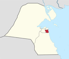 Map of Kuwait with Mubarak Al-Kabeer highlighted | |
| Coordinates (Mubarak Al-Kabeer): 29°12′44″N 48°03′38″E / 29.21222°N 48.06056°ECoordinates: 29°12′44″N 48°03′38″E / 29.21222°N 48.06056°E | |
| Country | |
| Districts | 8 |
| Area | |
| • Total | 100 km2 (40 sq mi) |
| Population (June 2014)[1] | |
| • Total | 230,727 |
| • Density | 2,300/km2 (6,000/sq mi) |
| Time zone | UTC+03 (EAT) |
| ISO 3166 code | KW-MU |

Mubarak Al-Kabeer Governorate (Arabic: محافظة مبارك الكبير Muḥāfaẓat Mubārak al-Kabīr) is one of the governorates of Kuwait which mainly houses residential areas of Kuwait City. It was formed in 2000 when the Hawalli Governorate was split in two.
Districts within the governorate include:
References[]
Places adjacent to Mubarak Al-Kabeer Governorate | ||||||||||||||||
|---|---|---|---|---|---|---|---|---|---|---|---|---|---|---|---|---|
| ||||||||||||||||
 | ||


Capital: Mubarak Al-Kabeer | |
This Kuwaiti location article is a stub. You can help Wikipedia by . |
Categories:
- Mubarak Al-Kabeer Governorate
- Governorates of Kuwait
- Kuwait geography stubs