Murchison Falls National Park
| Murchison Falls National Park | |
|---|---|
| Kabalega National Park | |
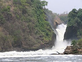 Murchison Falls | |
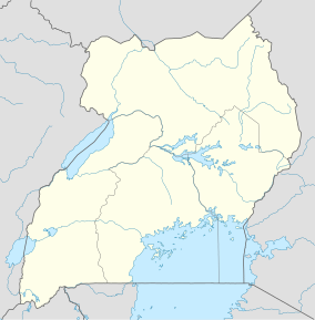 Location of Murchison Falls National Park | |
| Location | Uganda |
| Nearest city | Masindi |
| Coordinates | 02°11′15″N 31°46′53″E / 2.18750°N 31.78139°ECoordinates: 02°11′15″N 31°46′53″E / 2.18750°N 31.78139°E |
| Area | 3,893 km2 (1,503 sq mi) |
| Established | 1952 |
| Governing body | Ugandan Wildlife Authority |
| Official name | Murchison Falls-Albert Delta Wetland System |
| Designated | 15 September 2006 |
| Reference no. | 1640[1] |

Murchison Falls National Park (MFNP) is a national park in Uganda and managed by the Ugandan Wildlife Authority. It is in north-western Uganda, spreading inland from the shores of Lake Albert, around the Victoria Nile, up to the Karuma Falls.[2]
Together with the adjacent 748 square kilometres (289 sq mi) Bugungu Wildlife Reserve and the 720 square kilometres (280 sq mi) Karuma Wildlife Reserve, the park forms the (MFCA).[3]
Location[]
The park straddles the Ugandan districts of Buliisa, Nwoya, Kiryandongo, and Masindi.[2] The driving distance from Masindi, the nearest large town, to the Kibanda area of the national park is about 72 kilometres (45 mi).[4] This area is about 283 kilometres (176 mi), by road, north-west of Kampala, the capital and largest city of Uganda.[5] The coordinates of the park near the Kibanda area are 02°11'15.0"N, 31°46'53.0"E (Latitude:2.187499; Longitude:31.781400).[6]
History[]
The explorers John Speke and James Grant were the first Europeans to visit the present day MFCA in 1862. It was more thoroughly explored by Samuel and Florence Baker in 1863–4. Baker named the falls Murchison Falls after the geologist Roderick Murchison, then the president of the Royal Geographical Society.[7]
Between 1907 and 1912, the inhabitants of an area of about 13,000 square kilometres (5,000 sq mi) were evacuated due to sleeping sickness spread by tsetse flies. In 1910, the Bunyoro Game Reserve was created south of the River Nile. That area roughly corresponds to the part of the MFNP that is in the districts of Buliisa, Masindi, and Kiryandongo. In 1928, the boundaries were extended north of the river into the modern-day Nwoya District.[3]
In 1952, the British administration established the National Parks Act of Uganda. The area described above became Murchison Falls National Park.[3]
Overview[]

MFNP is Uganda's largest national park. It measures approximately 3,893 square kilometres (1,503 sq mi).[3] The park is bisected by the Victoria Nile from east to west for a distance of about 115 kilometres (71 mi).
The park is the location of the Murchison Falls, where the waters of the Nile flow through a narrow gorge only 7 metres (23 ft) wide before plunging 43 metres (141 ft).
Also in the park, adjacent to the Masindi-Gulu Highway, are the Karuma Falls, the location of the 600 megawatt Karuma Power Station, which will be Uganda's largest power station when it comes online circa 2022.[8]
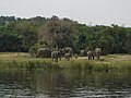
Wildlife[]
MFCA and the adjacent Bugondo Forest Reserve have 76 species of mammals as well as Uganda's largest population of Nile crocodiles. There are 450 known bird species in the park, including the rare shoe-billed stork, dwarf kingfisher, Goliath heron, white-thighed hornbill and great blue turaco.[9]
Since 2005, the protected area is considered a Lion Conservation Unit.[10] In 2010, it was estimated that only 250 giraffes were in the park. A population of 37 Rothschild's giraffes was transferred from the north side of the Nile River to the south side in 2016 and 2017, when population was around 1,500.[11][12]
Gallery[]
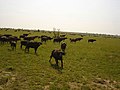
Herd of African buffaloes

Lions in the national park


See also[]
| Wikimedia Commons has media related to Murchison Falls National Park. |
- List of national parks of Uganda
References[]
- ^ "Murchison Falls-Albert Delta Wetland System". Ramsar Sites Information Service. Retrieved 25 April 2018.
- ^ Jump up to: a b Google (3 November 2016). "Map Showing The Location And Boundaries of Murchison Falls National Park" (Map). Google Maps. Google. Retrieved 3 November 2016.
- ^ Jump up to: a b c d UWA (3 November 2016). "About Murchison Falls National Park". Kampala: Uganda Wildlife Authority (UWA). Retrieved 3 November 2016.
- ^ Globefeed.com (3 November 2016). "Distance between Masindi Hotel, Masindi, Western Region, Uganda and Murchison Falls National Park, Kibanda, Western Region, Uganda". Globefeed.com. Retrieved 3 November 2016.
- ^ Globefeed.com (3 November 2016). "Distance between Kampala Road, Kampala, Uganda and Murchison Falls National Park, Kibanda, Western Region, Uganda". Globefeed.com. Retrieved 3 November 2016.
- ^ Google (3 November 2016). "The Geographical Coordinates of Murchison Falls National Park" (Map). Google Maps. Google. Retrieved 3 November 2016.
- ^ Thomas Paul Ofcansky (2004). Baker, Sir Samuel White (1821–1893). Oxford Dictionary of National Biography, Oxford University Press. Retrieved 3 November 2016.
- ^ Nakkazi, Esther (17 August 2009). "Karuma Heralds Ea of Abundant Power". The EastAfrican. Nairobi. Retrieved 3 November 2016.
- ^ "Murchison Falls National Park: Biodiversity". 3 November 2016. Retrieved 3 November 2016.
- ^ IUCN Cat Specialist Group (2006). Conservation Strategy for the Lion Panthera leo in Eastern and Southern Africa. Pretoria, South Africa: IUCN.
- ^ Expeditions, Simba Africa (21 December 2016). "Murchison falls Giraffe translocation | Trekking Giraffes in Uganda". www.africa-expeditions.com. Archived from the original on 22 September 2020.
- ^ "Nubian Giraffe Conservation in Uganda". Giraffe Conservation Foundation. 23 February 2016. Archived from the original on 20 September 2020.
External links[]
| Wikivoyage has a travel guide for Murchison Falls National Park. |
- A reliable Website: A guide to Murchison Falls National Park.
- BirdLife International. "Important Bird Areas factsheet: Murchison Falls National Park".
- Overview at Uganda Wildlife Authority
- Updated Website Dedicated to Murchison Falls National Park
- Murchison Falls National Park Website
- Murchison Falls Game Park
| Authority control |
|---|
- IUCN Category II
- National parks of Uganda
- Buliisa District
- Kiryandongo District
- Masindi District
- Nwoya District
- Protected areas established in 1952
- Important Bird Areas of Uganda
- Ramsar sites in Uganda
- 1952 establishments in Uganda
- Victoria Basin forest-savanna mosaic