Murghob District
Murghob District
| |
|---|---|
| Ноҳияи Мурғоб | |
 | |
 Location of Murghob District in Tajikistan | |
| Coordinates: 38°10′N 73°55′E / 38.167°N 73.917°ECoordinates: 38°10′N 73°55′E / 38.167°N 73.917°E | |
| Country | |
| Region | Gorno-Badakhshan Autonomous Region |
| Capital | Murghob |
| Area | |
| • Total | 37,300 km2 (14,400 sq mi) |
| Population (2020)[1] | |
| • Total | 15,900 |
| • Density | 0.43/km2 (1.1/sq mi) |
| Time zone | UTC+5 (TJT) |
| Postal code | 736600 |
| Area code(s) | +992 3554 |
| Official languages | |

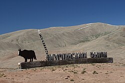
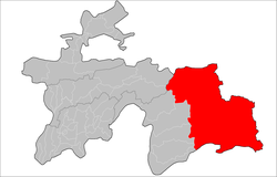
Murghob District or Marghov noyaa (Russian: Мургабский район, Tajik: Ноҳияи Мурғоб) is a district in Tajikistan, occupying the eastern two-thirds of the Gorno-Badakhshan Autonomous Region (GBAO). The area of Murghob District is 37,300 km2, covering 26 percent of Tajikistan's soil, but only 0.17% of its population.[3] Murghob District borders on Kyrgyzstan to the north, China to the east, and Afghanistan to the south.[4] The population of Murghob District is 15,900 (1 January 2020 estimate).[1] Its administrative capital is the village Murghob (also known as Murghab).
Administrative divisions[]
The district is divided administratively into six jamoats.[3] They are as follows:[5]
| Jamoat | Population (Jan. 2015)[5] |
|---|---|
| Alichur | 2,242 |
| 1,368 | |
| 757 | |
| Murghob | 7,468 |
| 1,675 | |
| 1,569 |
Geography[]
It borders on Afghanistan to the south, China's Xinjiang region to the east, and Kyrgyzstan to the north. Within Tajikistan it borders to the west on four other GBAO districts and on the Region of Republican Subordination.[6]
The land is mostly a desolate plateau with scattered mountains, especially toward the east and south. The highest mountains are around the Fedchenko Glacier in the northwest and along the Pamir River in the south. The population consists of around 65% Kirgiz who ascend to Pamirs in the late XIII century and the rest are Pamiris who are indigenous people of that and Chinese area of Pamirs. Formerly the highlands was used by both ethnicities mostly as summer pasture. The Pamir Highway curves from the southwest to the northeast. The four major lakes are Karakul in the northeast and three river lakes: Sarez Lake on the river Bartang, on the river Gunt, and Zorkul on the Pamir River.
The districts eastern border shares the Sarikol Range with China.
See also[]
References[]
- ^ a b "Population of the Republic of Tajikistan as of 1 January 2020" (PDF) (in Russian). Statistics office of Tajikistan. Retrieved 7 October 2020.
- ^ "КОНСТИТУЦИЯ РЕСПУБЛИКИ ТАДЖИКИСТАН". prokuratura.tj. Parliament of Tajikistan. Retrieved 9 January 2020.
- ^ a b "Regions of the Republic of Tajikistan 2017" (PDF) (in Russian). Statistics office of Tajikistan. pp. 15–21. Retrieved 12 October 2020.
- ^ Borjian, Habib, “Morḡāb” , Encyclopaedia Iranica. Online 2013. [1].
- ^ a b Jamoat-level basic indicators, United Nations Development Programme in Tajikistan, accessed 7 October 2020
- ^ Republic of Tajikistan, map showing administrative division as of January 1, 2004, "Tojikkoinot" Cartographic Press, Dushanbe
| Districts |  | |
|---|---|---|
| Main cities and towns | ||
| Geography | ||
| Rivers | ||
This Tajikistan location article is a stub. You can help Wikipedia by . |
- Districts of Tajikistan
- Gorno-Badakhshan Autonomous Region
- Tajikistan geography stubs