Murrhardt
show This article may be expanded with text translated from the corresponding article in German. (February 2009) Click [show] for important translation instructions. |
Murrhardt | |
|---|---|
 Coat of arms | |
show Location of Murrhardt | |
 Murrhardt | |
| Coordinates: 48°58′48″N 09°34′53″E / 48.98000°N 9.58139°ECoordinates: 48°58′48″N 09°34′53″E / 48.98000°N 9.58139°E | |
| Country | Germany |
| State | Baden-Württemberg |
| Admin. region | Stuttgart |
| District | Rems-Murr-Kreis |
| Subdivisions | 3 Stadtbezirke |
| Government | |
| • Mayor | Armin Mößner |
| Area | |
| • Total | 71.13 km2 (27.46 sq mi) |
| Elevation | 291 m (955 ft) |
| Population (2020-12-31)[1] | |
| • Total | 14,026 |
| • Density | 200/km2 (510/sq mi) |
| Time zone | UTC+01:00 (CET) |
| • Summer (DST) | UTC+02:00 (CEST) |
| Postal codes | 71540 |
| Dialling codes | 07192 (07184 in the City District of Kirchenkirnberg) |
| Vehicle registration | WN, BK |
| Website | www.murrhardt.de |


Murrhardt is a town in the Rems-Murr district, in Baden-Württemberg, Germany. It is located 12 km east of Backnang, and 18 km southwest of Schwäbisch Hall. The source of the Murr is situated in Murrhardt.
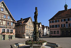
Murrhardt market place
Murrhardt Town hall
Church in Murrhardt
Local council (Gemeinderat)[]
Elections were held in May 2014:
- Christian Democratic Union of Germany / Free Electoral Union: 32.64% = 6 seats
- Social Democratic Party of Germany: 23.77% = 4 seats
- UL Independent list: 23.43% = 4 seats
- MD/AL-Murrhardt Democrats / Alternative List: 20,17 % = 4 seats
Mayor[]
Armin Mößner (CDU) was elected in July 2011 with 66,42 % of the vote. His predecessor was Dr. Gerhard Strobel.[2]
Sons and daughters of the town[]
- Heinrich von Zügel (1850-1941), painter
| show Towns and municipalities in Rems-Murr (district) |
|---|
References[]
- ^ "Bevölkerung nach Nationalität und Geschlecht am 31. Dezember 2020". Statistisches Landesamt Baden-Württemberg (in German). June 2021.
- ^ http://www.wahlen.kdrs.de/AGS119044/119044m.htm
| show Authority control |
|---|
This Rems-Murr location article is a stub. You can help Wikipedia by . |
Categories:
- Towns in Baden-Württemberg
- Rems-Murr-Kreis
- Württemberg
- Stuttgart region geography stubs