Muscle Ridge Islands, Maine
Muscle Ridge Islands, Maine | |
|---|---|
Unorganized territory | |
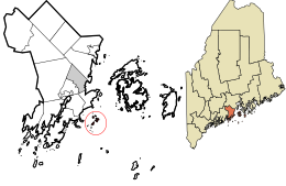 Location in Knox County and the state of Maine. | |
| Coordinates: 44°2′31″N 69°2′19″W / 44.04194°N 69.03861°WCoordinates: 44°2′31″N 69°2′19″W / 44.04194°N 69.03861°W | |
| Country | United States |
| State | Maine |
| County | Knox |
| Area | |
| • Total | 49.7 sq mi (128.6 km2) |
| • Land | 0.95 sq mi (2.45 km2) |
| • Water | 48.7 sq mi (126.2 km2) |
| Population (2010) | |
| • Total | 6 |
| Time zone | UTC-5 (Eastern (EST)) |
| • Summer (DST) | UTC-4 (EDT) |
| Area code(s) | 207 |
| FIPS code | 23-47962 |
| GNIS feature ID | 1934678 |

Muscle Ridge Islands is an archipelago and unorganized territory off the coast of South Thomaston in Knox County, Maine, United States.[1] The population was 6 at the 2010 census.[2]
Geography[]
According to the United States Census Bureau, the unorganized territory has a total area of 49.7 square miles (128.6 km2), of which 0.95 square miles (2.45 km2) is land and 48.7 square miles (126.2 km2) is water (98%).[3] The archipelago includes over a dozen islands, including Andrews, Dix, Fisherman, Pleasant, and Two Bush Island, which is home to the Two Bush Island Light.[4]
References[]
- ^ U.S. Geological Survey Geographic Names Information System: Muscle Ridge Islands, Maine
- ^ "Profile of General Population and Housing Characteristics: 2010 Demographic Profile Data (DP-1): Muscle Ridge Islands UT, Maine". United States Census Bureau. Retrieved July 13, 2020.
- ^ "U.S. Gazetteer Files 2019". United States Census Bureau. Retrieved July 13, 2020.
- ^ "Muscle Ridge Shoals Township". Maine: An Encyclopedia. Retrieved July 13, 2020.
Municipalities and communities of Knox County, Maine, United States | ||
|---|---|---|
| City |  | |
| Towns | ||
| Plantation | ||
| Unorganized territories | ||
| CDPs | ||
| Other villages | ||
| ||
Categories:
- Unorganized territories in Maine
- Populated places in Knox County, Maine