Nagar District
Nagar District
ضلع نگر | |
|---|---|
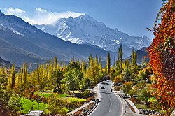 A view of Rakaposhi from the Nagar Valley | |
 Map of Gilgit-Baltistan with the Nagar District highlighted in red | |
| Sovereign state | Pakistan |
| Administered territory | Gilgit-Baltistan |
| Division | Gilgit Division |
| Headquarters | Nagarkhas |
| Area | |
| • Total | 5,000 km2 (2,000 sq mi) |
| Population (1998)[citation needed] | |
| • Total | 51,387 |
| Number of tehsils | 2 |
The Nagar District (Urdu: ضلع نگر) is one of the 14 districts of Pakistan-administered territory of Gilgit-Baltistan.[1] The Nagar District was established in 2015 by the division of the Hunza–Nagar District into two districts: the Hunza District and the Nagar District. The Nagar District is bounded on the north and north-east by the Hunza District, on the south-east by the Shigar District, on the south by the Gilgit District, and on the west by the Gupis-Yasin District. The district headquarters in the town of Nagarkhas.
Administration[]
The District Nagar administratively comprises two Tehsils, Tehsil Nagar-I and Tehsil Nagar-II.[2] All the villages of upper Nagar including Shayar, Askurdas, Sumayar, Nagarkhas, Hoper Valley, and Hispar come under the Tehsil Nagar-I. While all the villages of lower Nagar including Bar, Chalt, Buladas, Chaprote, Skandarabad, Jafarabad, Nilt, Thol, Ghulmet, Pisan, Minapin, Meacher, Dadhimal, Phekar, and Hakuchar are the par of Tehsil Nagar-II.
Political representation[]
At the provincial level, the district is represented by two elected members to Gilgit-Baltistan Legislative Assembly according to the following constituencies:
- GBLA-4 (Nagar-II)
- GBLA-5 (Nagar-I)
See also[]
- Nagar Valley
- Hopar Valley
- Sumayar Valley
- Hisper Valley
- Gilgit District
References[]
- ^ "Dividing governance: Three new districts notified in G-B". Express Tribune. Express Tribune. Retrieved 12 April 2017.
- ^ "GEOGRAPHY & DEMOGRAPHY OF GILGIT BALTISTAN".
This Gilgit-Baltistan location article is a stub. You can help Wikipedia by . |
- Nagar District
- Districts of Gilgit-Baltistan
- Gilgit-Baltistan geography stubs