Nagar Valley
This article needs additional citations for verification. (December 2018) |
Nagar Valley نگر | |
|---|---|
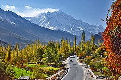 The 7,788 m (25,551 ft) tall Rakaposhi as seen from the Nagar Valley | |
 Nagar Valley نگر Location in Pakistan | |
| Coordinates: 36°15′55″N 74°42′49″E / 36.2652548°N 74.7135025°ECoordinates: 36°15′55″N 74°42′49″E / 36.2652548°N 74.7135025°E[1] | |
| Country | Pakistan |
| Region | Gilgit Baltistan |
| District | Nagar District |


Nagar (Nager[2]) (Urdu: نگر; Burushaski: نگر) is a former princely state and one of the ten districts of Gilgit Baltistan, Pakistan.[3][4] The valley is along the Karakoram Highway on the way north from Gilgit main city. The valley is home to many high mountain peaks including Rakaposhi (7788m), Diran Peak (7265m), Golden Peak and Rush Peak. The Nagar valley is administratively divided into two Tehsils; Tehsil Nagar-I and Tehsil Nagar-II.[5] All the villages of upper Nagar including Shayar, Askurdas, Sumayar, Nagarkhas, Hoper Valley, and Hispar come under the Tehsil Nagar-I. While all the villages of lower Nagar including , Chalt Bala, Sonikot, Akbarabad, Rabat, Bar, Buddalas, Chaprote, Skandarabad, Jafarabad, Nilt, Thol, Ghulmet, Pisan, Minapin, Meacher, Dadhimal, Phekar, and Hakuchar are the par of Tehsil Nagar-II. Burushaski and Shina languages are spoken in the valley.[3] The Rush Lake, the highest alpine lake of Pakistan and the 27th highest lake in the world also lies in this valley.
Etymology[]

The term Nagar [nʌɡʌr] is derived from a Sanskrit word "Nagara" which means a town, a city, an area in a city, or an area where people live that is outside the center of a city.[6]
According to A Dictionary of Jewish Babylonian Aramaic of the Talmudic and Geonic Periods by Michael Sokoloff, the history of the term Nagar goes further back to the ancient city "Sumerian Nagar".[7] Along with Kish, Mari and Ebla, the Nagar was one of the important cities of the earliest known civilization Sumer in the region of Upper Mesopotamia (now northwestern Iraq and northeastern Syria)[8] during the sixth and fifth millennium BC.[9] The ancient city is now known as Tell Brak and is located in Syria.[10][11][12]
Moreover, Klein's etymological dictionary of Rabbinic Hebrew, traces the word Nagar from Akkadian "Naggaru" which means carpenter or the skilled carpenter.[7][13]
Geography[]
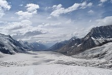
The entire region is hilly and mountainous topographically, but every part of the valley is easily accessible. The Karakoram mountain range covers the whole region, of which Rakaposhi is one part. Of the total area of Nagar valley, 90% is above 3,000 meters above sea level and 30% is 5,000 meters above sea level.[14]
History[]

Nagar was an independent principality for more than 1200 years. The British gained control of Nagar during a battle of the Anglo-Brusho war which is locally known as Jangir-e-Lae. Jangir-e-Lae was fought between the people of Nagar state and the troops of the British Raj at the place of Nilt, from 1 to 23 December 1891.[15] The British troops faced intense resistance from the people of Nagar under the leadership of the Tham (Chief) of that time Azur Khan at the Nilt Nallah (known as, Jamila Mo Har).[16] The people of Nagar fought bravely for more than 20 days but were defeated due to a lack of armaments. Over 100 people of Nagar lost their lives and 127 were imprisoned. On the British side, four British Officers and over 50 Dogra levies lost their lives.[15] The British retained Nagar's status as a principality.[17] Even after the revolt against the Maharaja of Kashmir and unconditional accession to Pakistan in 1948, Nagar's status continues to be a Princely state. During the 1960s, people start protesting against the despotism of the Mir, demanding the abolition of Begar and reduction in taxation. In 1970, they organized the march to Gilgit to register their demands to the high-ups, while from Gilgit scouts were sent against the people. The scouts open fire at the demonstration in Chalt and killed nine persons and wounded many more. The leaders of the protest were imprisoned.[2] Later, on 25 September 1974 the Zulfiqar Ali Bhutto dissolved the Princely States of Nagar and Hunza and set the prisoners free and gave democratic representation to the Northern Areas Council, now the Gilgit-Baltistan Legislative Assembly.[18]
Tourist Attractions[]


Meadows and Pastures[]
Nagar is home to many famous high altitude meadows such as:
- Taghafari
- Gappa Valley
- Bar Ter
- Barpu
- Sumayar Bar
- Silkiyang
- Hapakun
Mountain Peaks[]
Famous peaks in the region are:
- Rakaposhi
- Diran
- Golden Peak (also Known as Spantik)[circular reference]
- Miar Peak (Miar Chhish)
- Alchori Sar
- Hispar Sar
- Kunyang Chhish
- Malubiting
Lakes[]
Famous alpine Lakes in the region are:
Glaciers[]
Famous Glaciers in the region are:
- Hopar Glacier
- Miar Glacier
- Hisper Glacier
- Biafo Glacier
- Barpu Glacier
- Minapin Glacier
- Pisan Glacier
- Silkiyang Glacier
Mountain Passes[]
Famous Passes in the region are:
- Hispar Pass also known as Hispar La
- Chaprot Pass
- Chumar Bakur Pass
See also[]
- Hoper Valley
- Hisper Valley
- Nagarkhas
- Hunza Valley
- Naltar Valley
- Shigar valley
References[]
- ^ "Nagar on map". Google Maps. Retrieved 15 September 2019.
- ^ a b Martin, Sokefeld (2005). "From Colonialism to Postcolonial Colonialism: Changing Modes of Domination in the Northern Areas of Pakistan". The Journal of Asian Studies. 64 (4): 939–973. doi:10.1017/S0021911805002287. JSTOR 25075905.
- ^ a b "Nagar Valley". visitgilgitbaltistan.gov.pk. Retrieved 15 September 2019.
- ^ "Nagar Valley, Gilgit Baltistan, Pakistan". myadventure.pk. Retrieved 7 November 2018.
- ^ "GEOGRAPHY & DEMOGRAPHY OF GILGIT BALTISTAN".
- ^ "Meaning and Origin of: Nagar". Familyeducation. Retrieved 7 March 2021.
- ^ a b "nagar". Balashon Hebrew language detective. Retrieved 7 March 2021.
- ^ Andersson, J (2012). "Kingship in the Early Mesopotamian Onomasticon 2800–2200 BCE" (PDF). Doctoral dissertation, Acta Universitatis Upsaliensis. Retrieved 7 March 2021.
- ^ Adamo, N; Al-Ansari, N (2020). "The Sumerians and the Akkadians: The Forerunners of the First Civilization (2900-2003BC): The Sumerians and the Akkadians: The Forerunners of the First Civilization (2900-2003BC)". Earth Sciences and Geotechnical Engineering. 10 (3). Retrieved 7 March 2021.
- ^ Eidem, J; Warburton, D (1996). "In the Land of Nagar: A Survey around Tell Brak". Iraq. 58: 51–64. doi:10.1017/S0021088900003168.
- ^ Oates, Joan. [Joan "Archaeology in Mesopotamia: Digging Deeper at Tell Brak"]. Retrieved 15 March 2021.
{{cite web}}: Check|url=value (help) - ^ Ur, Jason; Karsgaard, Philip (2011). "THE SPATIAL DIMENSIONS OF EARLY MESOPOTAMIAN URBANISM: THE TELL BRAK SUBURBAN SURVEY, 2003–2006". Iraq. 73: 1–19. doi:10.1017/S0021088900000061. S2CID 33518626.
- ^ Civil, M; Feliu, Mateu (2017). "Studies in Sumerian Civilization". Barcino Monographica Orientalia. 7.
- ^ Spies, Michael (2019). Norther Pakistan: High Mountain Farming and Changing Socionatures. Lahore Pakistan: Vanguard books. p. 63. ISBN 9789694026091.
- ^ a b Syed, Yahya. Broshaal Ke Qabail. Gilgit: North News Agency.
- ^ Zulfiqar Ali, Khan; Farman Karim, Baig. "128th Anniversary of the Anglo-Burusho War". PAMIR TIMES. Retrieved 24 December 2020.
- ^ Masud, Khan. "Anglo-Brusho War Of 1891". Daily Times.
- ^ Sajjad, Ahmad. "HISTORY: THE GILGIT-BALTISTAN CONUNDRUM". Dawn. Retrieved 24 December 2020.
| Wikimedia Commons has media related to Nagar Valley. |
General[]
- Leitner, G. W. (1893): Dardistan in 1866, 1886 and 1893: Being An Account of the History, Religions, Customs, Legends, Fables and Songs of Gilgit, Chilas, Kandia (Gabrial) Yasin, Chitral, Hunza, Nagyr and other parts of the Hindukush, as also a supplement to the second edition of The Hunza and Nagyr Handbook. And An Epitome of Part III of the author’s "The Languages and Races of Dardistan". First Reprint 1978. Manjusri Publishing House, New Delhi.
External links[]
| Wikivoyage has a travel guide for Northern_Areas_(Pakistan). |
- Valleys of Gilgit-Baltistan
- Populated places in Nagar District