Nairn Falls Provincial Park
| Nairn Falls Provincial Park | |
|---|---|
IUCN category II (national park) | |
 Nairn Falls | |
 Location of Nairn Falls Provincial Park in British Columbia | |
| Location | British Columbia, Canada |
| Nearest city | Pemberton |
| Area | 170 hectare |
| Established | 4 April 1966 |
| Governing body | BC Parks |
| Website | BC Parks Nairn Falls |
This article relies largely or entirely on a single source. (August 2021) |
Nairn Falls Provincial Park is a provincial park in British Columbia, Canada located on the Green River adjacent to British Columbia Highway 99 and the Canadian National Railway line just south of Pemberton and less than twenty minutes north of the resort town of Whistler. The 170 hectare park was established in 1966, shortly after the highway's opening, to protect and enhance visitor access to Nairn Falls.
Nairn Falls[]
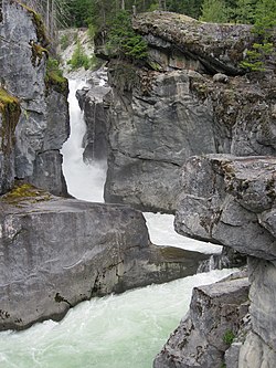
Nairn Falls is a tiered waterfall connected by a small canyon which throttles the flow of the Green River just before its accession to the lowlands of the Pemberton Valley and its confluence with the Lillooet River just above that river's estuary into Lillooet Lake. The waterfall measures 39.6 metres (130 ft) tall and has an average width of 9.1 metres (30 ft).
Facilities[]
The park's campground, located in forest land near the falls, has 94 vehicle-accessible sites and is open from May to October.
References[]
- Waterfalls of the Pacific Northwest. "Nairn Falls". Retrieved 2007-11-08.
External links[]
- BC Parks Info Site on Nairn Falls
- Youtube: Nairn Falls by obhol #1
- Youtube: Nairn Falls by obhol #2
- Youtube: Narin Falls by wonderSpud #1
- Youtube: Narin Falls by wonderSpud #2
- Hike to the Nairn Falls Waterfall
Protected areas of British Columbia | |||||||||||||||||||||||||||||||||||||||||||||||||||||||||||||||||||||||||
|---|---|---|---|---|---|---|---|---|---|---|---|---|---|---|---|---|---|---|---|---|---|---|---|---|---|---|---|---|---|---|---|---|---|---|---|---|---|---|---|---|---|---|---|---|---|---|---|---|---|---|---|---|---|---|---|---|---|---|---|---|---|---|---|---|---|---|---|---|---|---|---|---|---|
| |||||||||||||||||||||||||||||||||||||||||||||||||||||||||||||||||||||||||
| |||||||||||||||||||||||||||||||||||||||||||||||||||||||||||||||||||||||||
| |||||||||||||||||||||||||||||||||||||||||||||||||||||||||||||||||||||||||
| |||||||||||||||||||||||||||||||||||||||||||||||||||||||||||||||||||||||||
| |||||||||||||||||||||||||||||||||||||||||||||||||||||||||||||||||||||||||
| |||||||||||||||||||||||||||||||||||||||||||||||||||||||||||||||||||||||||
| |||||||||||||||||||||||||||||||||||||||||||||||||||||||||||||||||||||||||
| |||||||||||||||||||||||||||||||||||||||||||||||||||||||||||||||||||||||||
| |||||||||||||||||||||||||||||||||||||||||||||||||||||||||||||||||||||||||
| |||||||||||||||||||||||||||||||||||||||||||||||||||||||||||||||||||||||||
Coordinates: 50°17′37″N 122°49′08″W / 50.29373°N 122.8189°W

- IUCN Category II
- Provincial parks of British Columbia
- Waterfalls of British Columbia
- Pemberton Valley
- 1966 establishments in British Columbia
- Protected areas established in 1966