Tricouni Peak
| Tricouni Peak | |
|---|---|
 | |
| Highest point | |
| Elevation | 2,122 m (6,962 ft) |
| Prominence | 252 m (827 ft) |
| Coordinates | 50°00′49.4388″N 123°14′41.0598″W / 50.013733000°N 123.244738833°WCoordinates: 50°00′49.4388″N 123°14′41.0598″W / 50.013733000°N 123.244738833°W[1] |
| Geography | |
| Location | British Columbia, Canada |
| District | New Westminster Land District |
| Parent range | Pacific Ranges |
| Topo map | NTS 92J3 |
| Climbing | |
| First ascent | 1931 J. Cherry; T. Fyles; H. Wynne |
| Easiest route | rock/ice climb |

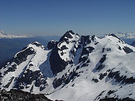
Tricouni Peak is a mountain located south of Cypress Peak on the Squamish-Cheakamus divide within the Pacific Ranges of the Coast Mountains in southwestern British Columbia, Canada. It was named in 1931 by Tom Fyles et al., the first ascent party. According to Tom Fyles himself,[2] "Tricouni Mountain was the name suggested for the peak, as from a distance it had the appearance of three cones". A misinterpreted "resemblance to a 3-pointed tricouni boot nail" was mentioned only much later, and not by Fyles. The name "Tricouni Peak" was adopted on 22 June 1967.[3]
References[]
- ^ "Tricouni Peak". Openstreetmap. Retrieved 21 August 2017.
- ^ Canadian Alpine Journal, vol. XX, 1931, p. 63
- ^ "Tricouni Peak". BC Geographical Names.
This article about a location on the Coast of British Columbia, Canada is a stub. You can help Wikipedia by . |
Categories:
- Two-thousanders of British Columbia
- Pacific Ranges
- New Westminster Land District
- British Columbia Coast geography stubs