Naryn Castle, Meybod
This article has multiple issues. Please help or discuss these issues on the talk page. (Learn how and when to remove these template messages)
|
| Naryn Castle | |
|---|---|
نارین قلعه | |
 | |
 | |
| General information | |
| Type | Castle |
| Architectural style | Iranian architecture |
| Town or city | Meybod |
| Country | |
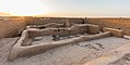
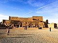
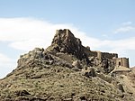
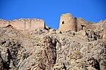
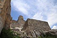
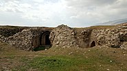
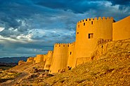
The Naryn Castle (In Persian: نارین قلعه) or Narin Castle is a mud-brick fort or castle in the town of Meybod, Iran.[1] Structures like these constituted the government stronghold in some of the older (pre-Islamic) towns of central Iran. Some of these castles incorporate mud bricks of the Medes period and of the Achaemenid and Sassanid dynasties.
The ruins of the structure stands 40 meters (130 ft) high from its base. Although built some 2,000 years ago, it contains what seems to be a type of plumbing system (made out of a kind of mortar called sarooj) which was built into its massive walls. It is also peculiarly similar in design to Ali Qapu palace of Isfahan; it has a terrace high on top of the structure whose circulation is provided by two helical stairwells (whose walls have caved in, making it inaccessible). The structure also has a large underground chamber (filled now by rubble), possibly a prison. Four towers surround the entire compound, and a large gate furnishes access to a large courtyard. The structure seems to have been the victim of numerous earthquakes throughout the ages.
Some believe that the Narin castles are descendants of ancient fire-temples; some of the castles in Narin and Meybod, in Yazd province, are also called nareng castles (orange castles), possibly by folk etymology. The castle at Meybod is currently under study. Yet this castle has not been faring very well.
This building has been built as an old fortress with 3 different floors, each for a different class of society.
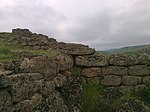
Although all outer gates have been destroyed the inner castle still exists. You can still see some of the outer walls.
Gallery[]

View of the yard.

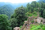
Interior of the citadel.

Top area.
Ruins of a former building.

View from the top.

View of Meybod from the citadel.
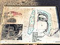
Narin Qal'eh or Narin Castle The View of Map
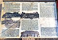
Narin Qal'eh or Narin Castle The View of History

Narin Qal'eh or Narin Castle - The View from castle to front yard

Narin Qal'eh or Narin Castle - Part of the castle from inside

Narin Qal'eh or Narin Castle - A Panoramic view of Meybod and Back of castle capture form the high part of castle

Narin Qal'eh or Narin Castle, a view of castle from inside
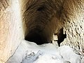
Narin Qal'eh or Narin Castle - Some tunnels inside the castle
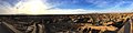
Narin Qal'eh or Narin Castle - Panoramic view of Meybod from Castle
Narin Qal'eh or Narin Castle


See also[]
- List of Iranian castles
- Iranian architecture
Sources[]
- ^ "Naryn castle". Encyclopedia of History of Iranshahr Architecture. Archived from the original on 2015-04-06. Retrieved 20 July 2019.
| Wikimedia Commons has media related to Narin Castle (Meybod). |
| Capital |
|  | |||||||||||||||||||||||||||||||||||||||||||||||
|---|---|---|---|---|---|---|---|---|---|---|---|---|---|---|---|---|---|---|---|---|---|---|---|---|---|---|---|---|---|---|---|---|---|---|---|---|---|---|---|---|---|---|---|---|---|---|---|---|---|
| Counties and cities |
| ||||||||||||||||||||||||||||||||||||||||||||||||
| Sights |
| ||||||||||||||||||||||||||||||||||||||||||||||||
| See also |
| ||||||||||||||||||||||||||||||||||||||||||||||||
Iranian architecture | ||||||||
|---|---|---|---|---|---|---|---|---|
| Styles |
|  | ||||||
| Types |
| |||||||
| Elements | ||||||||
| Traditional cities |
| |||||||
| Theory and analysis |
| |||||||
| Lists |
| |||||||
| East Azerbaijan |
| 
 |
|---|---|---|
| West Azerbaijan |
| |
| Isfahan |
| |
| Ardabil |
| |
| Alborz |
| |
| Bushehr |
| |
| Kohgiluyeh and Boyer-Ahmad | ||
| Golestan | ||
| Gilan |
| |
| Tehran |
| |
| Chaharmahal and Bakhtiari |
| |
| North Khorasan |
| |
| Razavi Khorasan |
| |
| South Khorasan |
| |
| Khuzestan |
| |
| Kurdistan | ||
| Semnan |
| |
| Sistan and Baluchestan |
| |
| Fars |
| |
| Qazvin |
| |
| Qom |
| |
| Kerman |
| |
| Kermanshah |
| |
| Mazandaran |
| |
| Markazi |
| |
| Lorestan |
| |
| Ilam |
| |
| Hormozgan |
| |
| Hamadan |
| |
| Yazd |
| |
| Zanjan | ||
Also See: Castles in Iran | ||


| Azerbaijan |
| 
 | |||||||||||||||||||||||||||||||||||||||||||||||||||||
|---|---|---|---|---|---|---|---|---|---|---|---|---|---|---|---|---|---|---|---|---|---|---|---|---|---|---|---|---|---|---|---|---|---|---|---|---|---|---|---|---|---|---|---|---|---|---|---|---|---|---|---|---|---|---|---|
| Georgia |
| ||||||||||||||||||||||||||||||||||||||||||||||||||||||
| Iraq |
| ||||||||||||||||||||||||||||||||||||||||||||||||||||||
| Iran |
| ||||||||||||||||||||||||||||||||||||||||||||||||||||||
| Oman |
| ||||||||||||||||||||||||||||||||||||||||||||||||||||||
| Russia |
| ||||||||||||||||||||||||||||||||||||||||||||||||||||||
| Saudi Arabia |
| ||||||||||||||||||||||||||||||||||||||||||||||||||||||
Also See: Sasanian castles | |||||||||||||||||||||||||||||||||||||||||||||||||||||||


Coordinates: 32°13′34″N 54°00′52″E / 32.2261°N 54.0145°E

- Buildings and structures completed in the 1st century
- Sasanian castles
- Architecture of Iran
- Archaeological sites in Iran
- Buildings and structures in Yazd Province
- National works of Iran
- Castles in Iran