[3] Name on the Register
Image
Date listed[4]
Location
Description
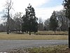
1
December 5, 1980 (#80001554 ) Kentucky Route 146 38°16′02″N 85°32′33″W / 38.267222°N 85.542500°W / 38.267222; -85.542500 (Anchorage Historic District )
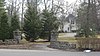
2
December 5, 1980 (#80001555 ) 804 Evergreen Rd. 38°15′24″N 85°32′17″W / 38.256667°N 85.538056°W / 38.256667; -85.538056 (The Anchorage )
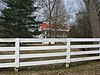
3
December 5, 1980 (#80001556 ) 1116 Bellewood Rd. 38°15′45″N 85°32′48″W / 38.262500°N 85.546667°W / 38.262500; -85.546667 (Bayless House )
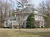
4
July 12, 1983 (#83002637 ) 12006 Ridge Rd. 38°15′42″N 85°31′54″W / 38.261667°N 85.531667°W / 38.261667; -85.531667 (Bonavita-Weller House )
5
July 12, 1983 (#83002638 ) 1111 Bellewood Rd. 38°15′42″N 85°32′38″W / 38.261528°N 85.543889°W / 38.261528; -85.543889 (Bonnycot )
6
Central Kentucky Lunatic Asylum Upload image July 12, 1983 (#83002646 ) 2201 Lakeland Rd. 38°16′41″N 85°33′18″W / 38.278056°N 85.555000°W / 38.278056; -85.555000 (Central Kentucky Lunatic Asylum )
7
November 11, 1977 (#77000622 ) 11405 Park Rd. 38°16′00″N 85°32′30″W / 38.266667°N 85.541667°W / 38.266667; -85.541667 (Citizens National Life Insurance Building )
8
December 5, 1980 (#80001557 ) 12005 E. Osage Rd. 38°16′11″N 85°31′59″W / 38.269722°N 85.533056°W / 38.269722; -85.533056 (Coldeway House )
9
December 5, 1980 (#80001558 ) 12006 Hazelwood Rd. 38°16′01″N 85°31′54″W / 38.267083°N 85.531667°W / 38.267083; -85.531667 (James Courteney House )
10
December 10, 1998 (#98001488 ) 12004 La Grange Rd. 38°16′40″N 85°31′03″W / 38.277778°N 85.517500°W / 38.277778; -85.517500 (Otto F. Eitel House )
11
April 9, 1984 (#84001559 ) 1103 Evergreen Rd. 38°15′40″N 85°32′12″W / 38.261250°N 85.536667°W / 38.261250; -85.536667 (Forrester House )
12
Upload image July 12, 1983 (#83002669 ) 2100 Evergreen Rd. 38°16′30″N 85°32′44″W / 38.275000°N 85.545556°W / 38.275000; -85.545556 (Garr House )
13
July 12, 1983 (#83002676 ) 1205 Elm Rd. 38°15′49″N 85°32′04″W / 38.263611°N 85.534444°W / 38.263611; -85.534444 (Richard Gwathmey House )
14
December 5, 1980 (#80001559 ) 1306 Evergreen Rd. 38°15′53″N 85°32′23″W / 38.264722°N 85.539722°W / 38.264722; -85.539722 (Hannah House )
15
Hausgen House
July 12, 1983 (#83002677 ) 1404 Walnut Lane 38°15′58″N 85°32′49″W / 38.266111°N 85.546944°W / 38.266111; -85.546944 (Hausgen House )
16
December 5, 1980 (#80001560 ) 11600 Owl Creek Rd. 38°15′38″N 85°32′28″W / 38.260556°N 85.541111°W / 38.260556; -85.541111 (Hillcrest )
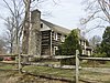
17
July 30, 1976 (#76000899 ) 12401 Lucas Lane 38°16′42″N 85°31′28″W / 38.278472°N 85.524583°W / 38.278472; -85.524583 (Hite-Foree Log House )
18
December 5, 1980 (#80001561 ) 1905 Stonegate Rd. 38°16′16″N 85°32′04″W / 38.271111°N 85.534444°W / 38.271111; -85.534444 (Jones Estate )
19
December 5, 1980 (#80001562 ) 12106 Osage Rd. 38°16′11″N 85°31′44″W / 38.269722°N 85.528889°W / 38.269722; -85.528889 (John Marshall, Sr., House )
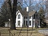
20
Robert May House
July 12, 1983 (#83002702 ) 11104 Owl Creek Lane 38°15��46″N 85°32′54″W / 38.262778°N 85.548333°W / 38.262778; -85.548333 (Robert May House )
21
Nash-McDonald House
December 5, 1980 (#80001564 ) 1306 Bellewood Rd. 38°15′52″N 85°32′39″W / 38.264444°N 85.544167°W / 38.264444; -85.544167 (Nash-McDonald House )
22
July 12, 1983 (#83002713 ) 12007 Log Cabin Lane 38°15′28″N 85°31′57″W / 38.257639°N 85.532500°W / 38.257639; -85.532500 (Newland Log House )
23
December 5, 1980 (#80001565 ) 1401 Elm Rd. 38°15′54″N 85°32′04″W / 38.265000°N 85.534444°W / 38.265000; -85.534444 (Nock House )
24
Presbyterian Manse
July 12, 1983 (#83002724 ) 1302 Bellewood Rd. 38°15′51″N 85°32′41″W / 38.264167°N 85.544722°W / 38.264167; -85.544722 (Presbyterian Manse )
25
December 5, 1980 (#80001566 ) 1500 Evergreen Rd. 38°15′56″N 85°32′25″W / 38.265556°N 85.540278°W / 38.265556; -85.540278 (Railway Depot )
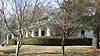
26
December 5, 1980 (#80001569 ) 1204 Maple Lane 38°15′46″N 85°32′25″W / 38.262778°N 85.540278°W / 38.262778; -85.540278 (St. Lukes Church )
27
Shallcross
December 5, 1980 (#80001567 ) 11804 Ridge Rd. 38°15′43″N 85°32′06″W / 38.261944°N 85.535000°W / 38.261944; -85.535000 (Shallcross )
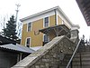
28
Upload image July 12, 1983 (#83002732 ) 2018 Homewood Dr. 38°16′36″N 85°32′10″W / 38.276667°N 85.536111°W / 38.276667; -85.536111 (Sherley Mansion )
29
December 5, 1980 (#80001568 ) 1509 Cold Spring Rd. 38°16′04″N 85°31′42″W / 38.267778°N 85.528333°W / 38.267778; -85.528333 (Simrall-Warfield House )
30
James Thompson House
December 5, 1980 (#80001570 ) 1400 Walnut Lane 38°15′54″N 85°32′49″W / 38.265000°N 85.546806°W / 38.265000; -85.546806 (James Thompson House )
31
Upload image July 14, 1983 (#83002743 ) 11801 Osage Rd. 38°16′09″N 85°32′11″W / 38.269167°N 85.536389°W / 38.269167; -85.536389 (Twin Gates Carriage House )
32
July 12, 1983 (#83002745 ) 1902 Evergreen Rd. 38°16′19″N 85°32′35″W / 38.272083°N 85.543056°W / 38.272083; -85.543056 (James Walker House )
33
December 5, 1980 (#80001571 ) 12200 Lucas Lane 38°16′36″N 85°31′41″W / 38.276667°N 85.528056°W / 38.276667; -85.528056 (John Webb House )
34
July 12, 1983 (#83002750 ) 11705 Owl Creek Lane 38°15′43″N 85°32′17″W / 38.261944°N 85.538056°W / 38.261944; -85.538056 (Eustace Williams House )
35
December 5, 1980 (#80001572 ) 11906 Ridge Rd. 38°15′42″N 85°32′02″W / 38.261667°N 85.533889°W / 38.261667; -85.533889 (Dr. Winston's House )